
With new snowfall across the higher elevations two days earlier, it was a good day to stay low and south, and return to a longtime favorite, the ledgy Lambert Ridge Trail on the SW side of Smarts Mountain. This inspired relocation on the Appalachian Trail was opened in the mid-1980s by the Dartmouth Outing Club, largely through the efforts of Bob Averill (editor of the two Moosilaukee Reader books and creator of the Sit Free or Die outhouse poster).
The trail starts at a parking area off the Lyme-Dorchester Road, shared with the Ranger Trail.

For the first half-mile the trail climbs steadily by switchbacks through a mixed hardwood forest. Near the bottom were some Red Trilliums.

Despite the recent snow, the trees were leafing out.

In a rocky oak-wooded area, Early Saxifrage was in bloom.
 The trail passes through a gap in an old stone wall. The 1931 USGS Mount Cube quadrangle shows this area as cleared land, perhaps pasture.
 At 0.8 mile, after a fairly steep climb, the trail breaks out onto the first of many quartzite ledges along Lambert Ridge. The view here looks SSW to Moose Mountain (center, in back) and Holts Ledge/Bear Hill (R).
 Holts Ledge features an impressive cliff band, a nesting site for Peregrine Falcons, along with trails of the Dartmouth Skiway.
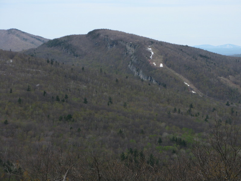 A zoom on Moose Mountain in Hanover, South Peak on the L and North Peak on the R. The AT crosses both of these peaks as well as Holts Ledge.
 Visibility was excellent, as shown by this view SW to the Killington Range.
 A little farther along the trail is this open clifftop perch, facing east.
 Mt. Cardigan rises in the distance beyond Reservoir Pond.
 Above the clifftop (1850 ft.) a couple inches of new snow blanketed the woods and the numerous grassy meadows along the trail. Much of the actual footway is bare ledge, and this rocky, erosion-proof strip was mostly snow-free. Some large gnarled old oaks rise beyond this meadow.
 Farther and higher on the ridge is an open ledgy area with another southerly vista.
Stratton Mountain was clearly visible on the horizon between North Moose and Holts Ledge. The tip of Mt. Ascutney pokes above North Moose.

The trail was covered with wet, slippery snow through this corridor of conifers.
 The snow persisted even in the sunny open hardwoods.
Up on the crest of the ridge, the trail leads you along little ledgy swaths.
 At 1.8 miles an open ledge provides the first look at the massive summit of Smarts, still two miles away by trail.
Another neat ledgy meadow along the trail.
 A window view west to the central Green Mountains.
 At 1.9 miles there's a large open ledge on the R side of the trail with an even better view of Smarts looming above the upper basin of Grant Brook. This is one hiker's favorite spot on the Lambert Ridge Trail.
 Interesting features seen on Smarts include the historic, restored fire tower, an old brushy scar (from a fire?) on the SW side of the summit, and the slide on the south face, which I had visited ten days earlier.
 The ledge provides a look down into the Grant Brook valley (the route of the Ranger Trail) and out to the eastern horizon.
 Mt. Cardigan is prominent to the SE.
Great place for a snooze in the spring sun, with no bugs in sight on this windy day.

After a long sojourn on the ledge, I continued a little farther N along the trail to this high hogback ledge.
 There was a glimpse N to (L to R) Mt. Cube, Mt. Clough and Mt. Moosilauke.
This nice hardwood glade was just N of the last ledgy spot on the ridge. The wet, slippery snow in the woods convinced me to turn around here and not attempt the descent off Lambert Ridge and the 1000-ft. climb to the summit of Smarts.
 By the time I headed back along the ridge, the sun had coaxed many Trout Lilies into bloom, even those that had been partly crushed by the weight of the recent wet snow.

During the intervening hours nearly all the snow had melted off this meadow.

Spring Beauties had also come out to greet the warm sun.
 I stopped for a few minutes on the clifftop perch, where Reservoir Pond had turned deep blue in the mid-afternoon sun.
 The hardwood descent off the south end of the ridge was now bone-dry. I highly recommend a hike on the Lambert Ridge Trail, even if you don't go to the summit of Smarts. (Post continues below.)
With a few hours of daylight left, I decided to pay a visit to Trout Pond, located in the town of Lyme's Trout Pond Forest on the W side of Smarts Mountain. (For information on this trail, see the website of the Upper Valley Land Trust.)
The trail begins at a parking area at the end of Hardscrabble Lane; the last 0.3 mi. along the road is narrow and rough and requires careful driving.
 A sign announces that you've arrived at the parking area.
 The first half-mile of the Trout Pond Trail is an uneventful walk along an old logging road; then the trail turns left and meanders through a nice hemlock forest.
 With rough and rocky footing, it descends to the W shore of the pond, where numerous sitting rocks invite you to admire the marvelous view across the water to Smarts Mountain and Lambert Ridge.
Zooming in on Smarts.
 The trail runs along the shore for 0.1 mile, bringing Smith Mountain, a low western satellite of Smarts, into view.
 From the SW shore of the pond you see the long, flat crest of Moody Mountain. Trout Pond has a real wild, backcountry feel to it. Kudos to those who helped protect it and to the Lyme Conservation Commission for maintaining the trail, a 1.8 mile round trip with very little elevation gain. The 12-acre pond is over 40 feet deep in the middle - a real gem!

No comments:
Post a Comment