
A LOOK BACK AT THE 2016 HIKING YEAR: JANUARY TO JUNE
In keeping with annual tradition, here is a sampling of many fine hikes and bushwhacks I enjoyed, sometimes solo, sometimes with good friends or my lovely wife, Carol, through the year just past. It was another good year in the mountains, returning to some old favorites and visiting some interesting new places. Here's to a great year for everyone in 2017!
I started the New Year off with an interesting bushwhack from the Drakes Brook Trail to some wild cliffs on the steep flank of Noon Peak. The view here looks across the cliffs to the summit of Sandwich Dome.

The snow-caked Tripyramids and West Sleeper from the clifftop vantage. The steep descent from here was spiced up with a snowshoe failure, but luckily the snow was not deep - a continuing theme in the winter of 2016.

The Tripyramids from another angle - at the top of the Dicey's Mill Trail near the summit of Mount Passaconaway.

A peek at Mount Osceola from a remnant open patch on an old slide in the Ravine of Avalanches, between North Tripyramid and Scaur Peak. Crusty snow and caked conifers made for slow going up this valley.

A southward view from an open ledge on the east side of Black Mountain (2732 ft.), a spur of Sandwich Dome, reached by snowshoe bushwhacking from the Smarts Brook Trail and then again from the Algonquin Trail.

A Boreal Chickadee stopped by for a visit.

Longtime bushwhacking companion Cath Goodwin takes a break in the sun on a ledge on the north spur of the Fool Killer, reached via a steep snowshoe bushwhack from the Sabbaday Brook Trail.

Mounts Passaconaway & Whiteface rise beyond the Sabbaday Brook valley.

A ledge near the summit of Middle Acteon Peak (on Acteon Ridge) offers a fine view of Sandwich Dome and the two Black Mountains. This was the first of three visits I made to this ledge in 2016; on this trip I followed a fine approach through open woods from the Yellow Jacket Trail..

The next week I bushwhacked from the Smarts Brook Trail to the spectacular open crest of Sachem Peak.

I was even able to sit in the sun for a bit and gaze across the broad upper valley of Smarts Brook.

In February my friend Mark Klim and I enjoyed a snowshoe bushwhack to Hogback Mountain, where we took in wide views over the Mill Brook valley and beyond to Mount Moosilauke.

A ledge on the north side of Hogback gave us a view up the Haselton Brook valley to the wild southern spurs of Mount Tecumseh, with the sharp summit poking up in back on the right.

An old slide on the flank of East Osceola, dating back to 1892, was one long ice flow in February.

A fractured rock face towers above The Flume of Waterville Valley, accessed by the new Irene's Path.

A ledge atop the cliff-faced NE spur ridge of East Osceola offers a Mount Willard-like view over Mad River Notch and the Greeley Ponds, with Tripyramid on the horizon. I approached up a long ridge from the Kancamagus Highway.

The view into the Ravine of Avalanches, between Scaur Peak and North Tripyramid, from the summit of Mount Tecumseh.

En route to the mysterious gap known as Lost Pass, Mark Klim and I explored remote beaver meadows at the head of Cascade Brook.

South Tripyramid overlooks the big beaver meadow in the heart of Lost Pass. This trek offered some of the season's best snowshoeing.

A crag below the main outlook on the steep flank of Snows Mountain looks across the Snows Brook basin to Sandwich Dome and its spurs.

A close-up look at the "K1 Cliff" on the west side of Mount Kancamagus, as seen from a projecting outcrop I call "The Beak."

This rock overhang on the west flank of Bald Knob (Acteon Ridge) is the entry to "Gandalf's Cave" and an obscure rock climbing route known as "Gollum's Escape."

Mark Kilm admires a gorgeous, Catskill-like glade in a col during a bushwhack along the Bald Mountain ridge, the long SE extension of West Tecumseh.

Mark takes in the view of Mount Tecumseh and its ledgy southern projections from ledges along the Bald Mountain ridge.

An amazing park-like col just north of the ledges.

View across the Haselton Brook valley to the ledgy Tecumseh spurs from an outcrop on Bald Mountain itself (about 2900 ft.). The shoulder in the center with the big granite slabs was once known as Spring Mountain, after a mineral spring house located at its base in the late 1800s.

Carol ambles through oak forest on the new Cabin Trail on Red Hill.

The fine north ledge on Fisher Mountain, which I accessed on this visit via a bushwhack from the Shattuck Brook valley.

Evening light illuminates the huge granite slab on the south shoulder of Dickey Mountain.

Mark Klim gazes out from an amazingly open fern meadow on the slope of trailless Mount Weetamoo in the Campton Range.

The excellent southern viewpoint near the summit of Mount Weetamoo.

The Loon Pond Mountain Cascades on Horner Brook, one of the "lost waterfalls."

A view of Sandwich Notch, Upper Hall Pond, and distant peaks from a tiny perch on the rugged flank of the trailless Campton Range.

Off for our late April vacation in the snow-free Catskills. On the first evening we strolled and geocached the Elm Ridge Trail, ending up at the beautifully-situated Elm Ridge Lean-To.

The next day I "bushwhacked" to Doubletop Mountain, mostly on a fairly defined herd path. The 3500-ft. Catskill peaks are clearly increasing in popularity. Along the way I negotiated this typical Catskill ledge band.

Gnarled and aged hardwoods on a shelf high on the flank of Doubletop.

The Burroughs Range from an elusive viewpoint on a "corner" of Doubletop.

Carol relaxes in a stone chair at Dibble's Quarry, along the Pecoy Notch Trail.

The next day I joined Laurie Rankin, accomplished Catskill hiker and Secretary of the 3500 Club, and Rick Brockway, outdoor columnist for the Oneonta, NY Daily Star, for an eight-mile bushwhack traverse of North Dome and Mount Sherrill, two trailless 3500-ft. peaks. We made our approach via the long, gentle southern ridge of North Dome. The ridge was open hardwoods almost all the way.

The ledge viewpoint on the steep eastern edge of North Dome was a phenomenal spot.

The view down a long scooped valley towards the Burroughs Range from the SE viewpoint on Mount Sherrill was, if anything, even more striking.

The next day Carol I hiked into wild Diamond Notch, between Southwest Hunter and West Kill Mountain.

The famous Katterskill Falls from a viewpoint accessed by a newly opened path.

On our last day I bagged two more 3500-ft. peaks, including Vly Mountain, whose summit canister is seen here.

I also ascended neighboring Bearpen Mountain, where jutting ledges offered views of unfamiliar country to the SW, with hills receding to Pennsylvania in the distance.

Back in the Whites, I continued a winter/spring trend of wandering in the Sandwich Range with a visit to Guinea Pond with its sprawling vista of Sandwich Dome.

En route to Black Mountain Pond, I made a short off-trail detour to this beaver pond vista of Mount Israel.

On another day I undertook a long ramble in the Sandwich Notch area, passing this waterfall on the brook between Upper Hall Pond and Middle Hall Pond.

Secluded Middle Hall Pond, 56 feet deep, with part of the Campton Range in the background.

A beaver meadow on the north side of Sandwich Notch, just inside the Sandwich Range Wilderness.

Bear Slide Cascade (a name applied in the late 1800s) on Clifford Brook, above Waternomee Falls, on the western flank of Carr Mountain.

Hurricane Falls, one of several interesting features seen while bushwhacking up along Clifford Brook.

On a May bushwhack, I found Dutchman's Breeches thriving in a col on the Bald Mountain ridge, SW of Mount Tecumseh.

My destinations on this bushwhack were the vast granite slabs of Spring Mountain, a spur of Green Mountain (south of Mount Tecumseh) that juts into the Haselton Brook valley.

I wondered if this remarkable crevice was the "Walker's Ice Cave" mentioned in a late 1800s guidebook.

Later in May Mark Klim and I embarked on an exploration in search of an obscure flume rumored to be in the col between Sandwich Dome and Flat Mountain. On our approach hike we stopped to admire Great Falls along the Bennett Street Trail.

After some fairly difficult bushwhacking we dropped onto the floor of the flume, which I had read of in two accounts by Waterville Valley historian and early/mid 1900s AMC trailsman Nathaniel Goodrich.

I soon returned to that general area for some exploring on either side of remote Flat Mountain Pond. One of my destinations was Hedgehog Camp (Camp 12) of the Beebe River Logging Railroad (1917-1942), where many artifacts could be seen.

Above the camp site I enjoyed some marvelous open bushwhacking on a spur ridge of East Sleeper. Here the West Spur of Whiteface is seen in the background.

On the other side of the valley, late in the day, I bushwhacked to a favorite ledge on a NE spur of Flat Mountain, gaining a view of Mount Whiteface and the northern part of Flat Mountain Pond.

On another trip I hiked to Livermore Pass from the Kancamagus Highway, then bushwhacked on a circuitous route through the woods to the edge of a beaver pond with a nifty view of the Tripyramids. This spot can be accessed more easily in the winter via the Kancamagus Brook Ski Trail.

On a fine day in late May I took a long walk up the Downes Brook valley, making a side trip off-trail to this huge 1920s slide on the west slope of the north ridge of Mount Whiteface.

I continued up the valley and then along the Kate Sleeper Trail to East Sleeper, passing through the incredible blowdown devastation inflicted by Hurricane Sandy in 2012. The trail passes through countless saw cuts made by volunteers of the Wonalancet Out Door Club, using hand tools only.

On the way down I made a side trip to the lower slabs of the Downes Brook (Passaconaway) Slide, catching the last rays of evening sun.

The following week I headed into the next valley to the west, Sabbaday Brook, and paid a second visit to the massive landslide unleashed on the slope of West Sleeper by 2011's Tropical Storm Irene.

Partway up the slide there's a view to Potash Mountain and distant peaks.

Looking down from near the top of the slide.

In early June I took a long walk up the Rocky Branch Trail to check out the reported 17 (!) relocations due to damage from Tropical Storm Irene. Deep in the valley, by chance I met AMC cartographer Larry Garland, who was heading in the other direction, GPSing the relocations for the maps in the forthcoming (2017) next edition of the AMC White Mountain Guide. Quite the coincidence, as I was checking the trail for the text revisions. After comparing notes for a while, we headed our separate ways.

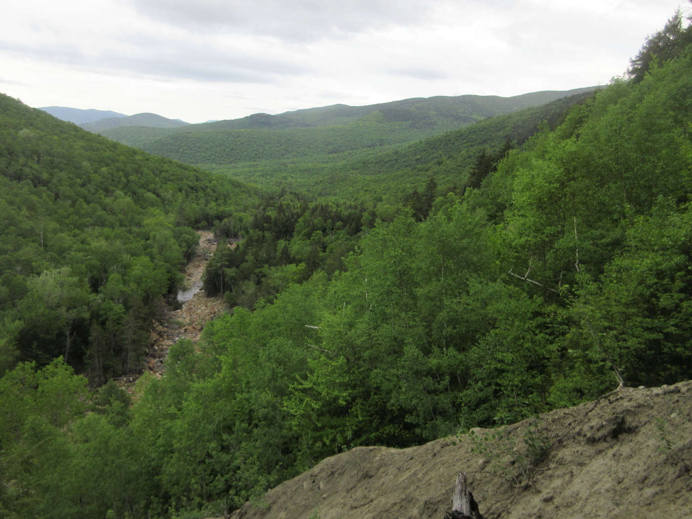
On the way back, I bushwhacked to the top of a steep gravel washout for a unique view down the lower Rocky Branch valley.
On an afternoon hike, I spent two glorious hours savoring the views from the summit ledge of Mount Osceola.

The unique view of Mount Chocorua and the fields of Wonalancet, from the summit of lowly Mount Katherine.

Linda Moore emerges at the top of the steep climb from the Oliverian Brook valley to Square Ledge. There are cliffs galore in this area!

Mount Passaconaway looms impressively when viewed from an outcrop near the summit of Square Ledge.

A short bushwhack off the Walden Trail dropped me at the top edge of a steep slab on the flank of Nanamocomuck Peak, with a vista east to Mounts Paugus and Chocorua.

Carol models her bug suit and headnet during black fly season at Upper Greeley Pond.

A bushwhack off the East Pond Trail to a beaver pond on Cheney Brook rewarded with a unique perspective on Mount Osceola. I usually visit this pond in winter; access is more difficult in summer.

The view of King Ravine, Durand Ridge and Mount Madison from the crag known as the Knight's Castle, off the Spur Trail, was a highlight of a loop hike over Mount Adams.

The most striking vista from the summit of Adams peers into the Great Gulf and Jefferson Ravine under the peaks of Mounts Washington and Jefferson.

The classic view down to John Quincy Adams, Star Lake and Mount Madison.

Looking down the great scoop of King Ravine with Durand Ridge, my descent route, on the right.

Ledges just down off the Sandwich Mountain Trail gaze out at Flat Mountain and the upper Drakes Brook valley.

