I spent a fine summer day wandering around the woods of Castle Ravine, the striking glacial cirque enclosed between high northern ridges of Mt. Jefferson and Mt. Adams. In addition to enjoying the bountiful brook scenery and peaceful forests of the ravine, I bushwhacked to two old slides on the west wall for some interesting views.
From the Presidential Rail Trail at the trailhead known as Bowman, you get a fine view of Mt. Jefferson, the sharp Castellated Ridge, and part of the headwall of Castle Ravine.
I headed in on the Castle Trail, making a Croc-assisted ford of the Israel River. Beyond the crossing, the trail briefly comes near the river and from a high bank not far off the trail I peered down at what I assume is the feature known as Israel Rapids.
For nearly a mile the Castle Trail runs at easy grades with good footing through an expansive hardwood forest.
Next up was a short stint on the Israel Ridge Path....
...which quickly comes to another crossing of the river. On with the Crocs, which I ended up using for 8 of 11 significant stream crossings along the day's route. Water levels had come down quite a bit, but the crossings here and on Castle Ravine Trail are rarely easy rock hops, as potential step stones are often pointy, oddly-angled and slick. This one I was able to rock hop on my way out in the evening, but in the morning I didn't want to chance wet boots.
At 1.7 miles from the trailhead the Castle Ravine Trail splits right as Israel Ridge Trail bears left and starts to ascend its namesake ridge.
A lightly-traveled pathway to adventure.
I bushwhacked down for a closer look at a cascade on Israel River that can be seen from the trail.
As the Randolph Paths guidebook notes, the walk into Castle Ravine offers "fine brook scenery."
The next crossing of Israel River presents some of those pointy rocks, which are very easy to slip off of. Crocs again.
Streamside walking.
Mossy rock wall on the ravine floor.
I've always found this crossing of Castle Brook to be the most awkward on the trail. Even with Crocs it took some maneuvering to get across, as the pool on the right is deceptively deep.
The next crossing, below a nice quad cascade, is much easier. This is one of my favorite spots in the ravine.
Then comes one of the prettiest stretches of trail in the Northern Presidentials.
One of the main objectives of the hike was to do some "field research" on the slides of Castle Ravine. A 1955 aerial photo shows at least six slides on the west wall of the ravine and two more on the east side. Edward Flaccus, who studied White Mountain landslides in the late 1950s, reported that these fell during the November 1927 storm or the September 1938 hurricane; most of them are now revegetated. A short bushwhack after the next crossing of Castle Brook brought me to the base of the northern of the two eastern slides, where I found a characteristic "debris flow levee" - a spine of boulders deposited by the slide - at the base of the overgrown track.
One of the old slides on the ravine's west wall still displays several bare rock slabs. By playing around with Google Earth, I figured these might offer a view of the ravine headwall. So I left the trail, forded the brook again, and angled up towards the lowest of the slabs. It wasn't too high up on the side wall, but the terrain was gnarly and slow going.
Looking back down.
I emerged at the lower edge of the slab and saw that trees blocked the view, so I would need to get to the top.
I made a wide switchback and found reasonable going across to the upper edge of the slab.
There was no way for me to safely climb this very steep and slimy ledge swath, which I later measured at a 41-degree pitch on the NH Granit website.
Looking across the upper part of the slab.
As for the headwall view of Castle Ravine, I was not disappointed.
Zoomed.
Zoomed some more. Note the light green strip, left of center, marking the track of a 1991 slide that spilled across the Castle Ravine Trail. The rocky patch to the left of the slide base is where the trail first emerges in the open on the headwall. It cuts across the base of that slide track, then struggles up steep talus to the top of the headwall and a trail junction near Edmands Col.
I also had a neat view up to the Castellated Ridge and The Castles.
Slab and cirque.
I found a better route to descend from the slab and circled around to its base for a look up at it.
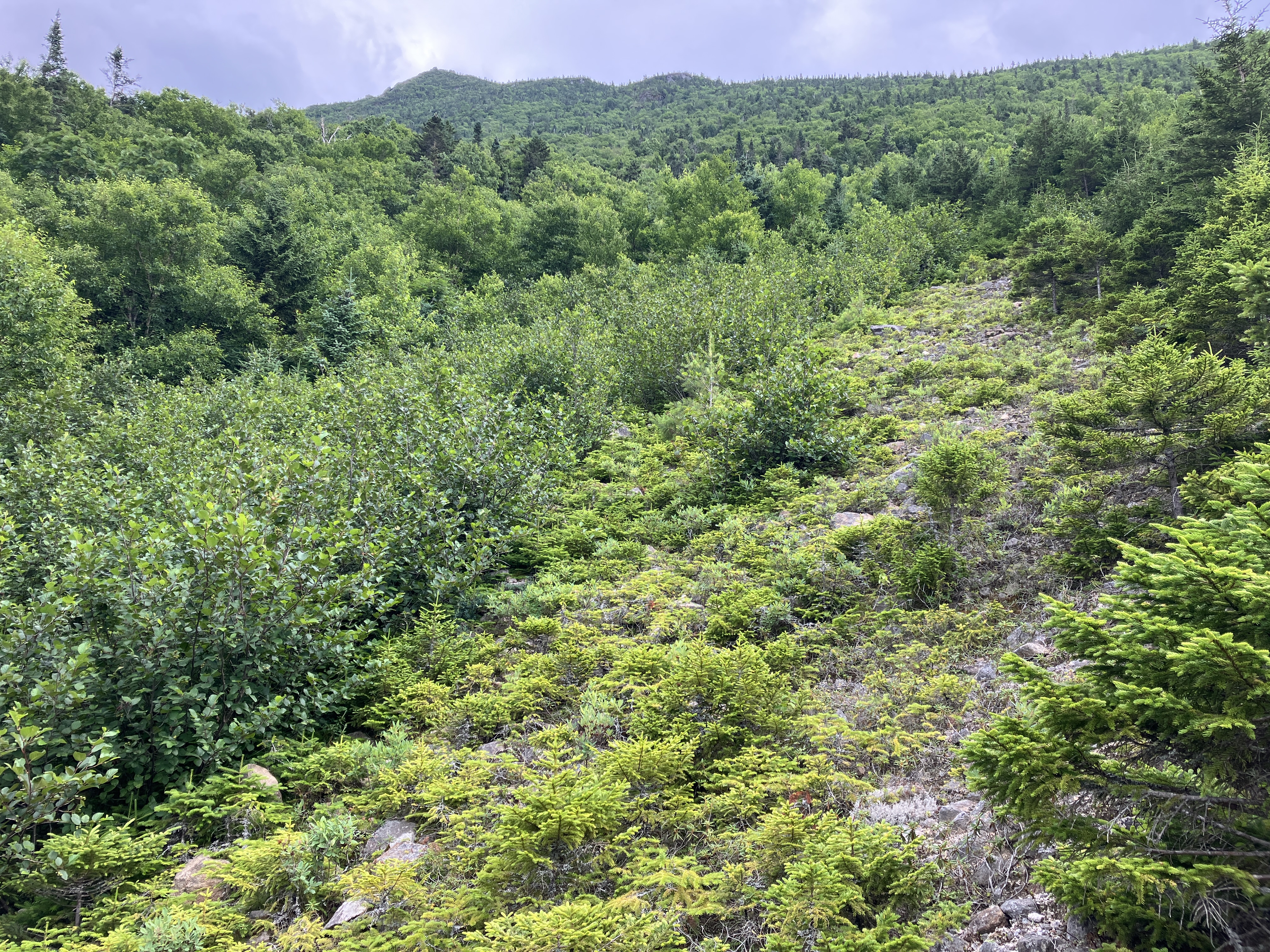
The other slide I wanted to visit is a half-mile south down the valley. To avoid two crossings of Castle Brook plus a steep climb back to the trail on the east side of the valley and then back down again, I opted to bushwhack that distance along the west side of the brook. I lucked out in that the floor of the valley was a broad trough with only a modest amount of sidehilling, and the woods were mostly open.
Along the way I passed the bottom of another old slide track, this one completely revegetated.
A wonderful whack.
Occasionally, a detour was needed around a blowdown patch.
Castle Brook was a constant companion.
A glimpse of the headwall upstream.
I knew I had reached the slide area when I came upon the telltale debris flow levee.
If you look at Google Earth or a satellite photo, you can see that there are actually two slides here. The eastern, wider and currently more open one - the slide I wanted to get up on - probably fell in the late 1960s or early 1970s, as it looks fresh on a 1972 aerial photo. The narrow western slide fell sometime in the mid to late 1990s. Only a sliver of gravel remains open on this one, which once provided a good view of the ravine headwall. I crossed the sapling-lined track of the narrow western slide...
...and then climbed a track with flowing water up to the eastern slide.
After pushing through a barrier of mega-dense spruce, I emerged on the still-open gravelly swath of the eastern slide, with a fine view out the valley to the NW.
The view took in Mt. Waumbek, South Weeks, Mt. Cabot, North Weeks, Unknown Pond Ridge, Long Mountain, Rogers Ledge and Deer Ridge.
Looking up the slide to the Castellated Ridge.
Partial view of the headwall.
Zoomed.
Israel Ridge leads up to the little bump of Emerald Bluff, from which I was peering into the ravine a few days earlier.
A formidable thicket of spruce and alder lines the edge of the open slide.
Descending. This is a comfortable slide with a relatively low angle of 27 degrees.
Once more across Castle Brook, easily rock-hopped here.
Whacking back up to the Castle Ravine Trail.
An attractive corridor of salt-and-pepper (birch and fir) woods here at 3100 ft.
Thank you, Randolph Mountain Club!
I continued another 0.2 mile south to the junction with the Emerald Trail.
After a peek up at Emerald Bluff, it was time to head back. For the descent, I opted for a loop on The Link and the Israel Ridge Path.
Could this really be the dreaded Link?
It gets more Link-like as it approaches the crossing of Cascade Brook at First Cascade
Looking down First Cascade.
Looking across at Mt. Bowman from the flat ledge atop the cascade. Skies were darkening, but I lucked out. While places like Lincoln and Pinkham Notch had downpours, I felt nothing more than a brief light sprinkle.
As it first descends below the Link junction, Israel Ridge Path is a little rough and roly-poly as it clings to a narrow sidehill. It is lightly-used and thus not badly eroded.
Below 2600 ft. it's smooth sailing, quite a contrast with the wide, wet, rocky and eroded footway of Lowe's Path, which I descended a few days earlier. On a fine summer day, in the Presidentials, I did not encounter a single hiker.