Tuesday, September 28, 2010

SABBADAY BROOK: 9/27/10

Low clouds and drizzle on the east side of the Kancamagus Highway foiled plans for a short morning climb in the Albany Intervale for some foliage views. Instead, I opted for a woods walk up the Sabbaday Brook Trail, which leads through one of my favorite valleys in the Whites. My new plan was to leave the trail partway up the valley and look for the point where a major tributary comes in to Sabbaday Brook off the E slopes of the Fool Killer. If conditions permitted, I would poke a little ways up this side stream in search of cascades.

This nameless brook drains a fairly large basin on the eastern flank of the Fool Killer, which is the flat-topped ridge in the foreground, under the Tripyramids, in this winter photo taken from Potash Mountain.


As at a couple of other trailheads I've visited recently, there was a nice new location map posted on the kisok.


The parking lot was empty when I set off a little after 8:00 am. For a little while, at least, I would be the only tramper on the Sabbaday Brook Trail.

It was fun to poke around ever-popular Sabbaday Falls with on one else around.

The gorgeous pool below the falls.

The lower falls, looking up the flume-like gorge.

The main falls of Sabbaday.


The smaller but very attractive upper falls.

Proceeding up the main trail, I found low water levels for the three brook crossings from 0.7 to 0.9 mile. Nevertheless, careful foot placement was needed as the rocks were wet from the drizzle and some were very slippery.

About a mile and a half in I passed the sign for the Wilderness boundary, though according to the maps this should be about 0.2 mi. farther N.

Farther up the valley I bushwhacked down to Sabbaday Brook and followed it upstream, pushing through wet vegetation. I enjoyed many nice views of this attractive backcountry brook.
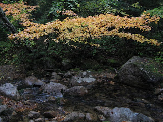


After a while I came to the point where the tributary off the Fool Killer enters Sabbaday Brook. I was expecting a more prominent confluence, and at first wondered whether this was the correct stream. But as I followed it upstream to the W, I saw that it was indeed a good-sized watercourse, albeit with a very low flow due to a prolonged lack of rainfall.


A short way up I found this mini-cascade.

Farther upstream was a formation that could be a decent waterfall after a heavy rain.


At times I took to the woods on the steep N slope of the brook's ravine.


Perhaps 0.2 mile up the side valley I came upon this humble but appealing mossy cascade. It, too, would be more impressive with a better flow. It was a nice spot to take a break, though there were no dry seats in the house.


I then continued farther upstream to where two forks of the brook join - a larger southern branch and a smaller northern one. For the return trip down to Sabbaday Brook, I took to the woods above the S side of the ravine, where open hardwoods provided better going than the sometimes blowdown-strewn conifers on the N side.


Back down on Sabbaday Brook, I explored farther upstream in an area where the valley has a fairly broad, flat floor.

On the W side of the brook was a gorgeous glade of open hardwoods.

Standing tall in this glade were several old, gnarled sugar maples.


I whacked back up to the trail and walked about two miles out, the last few minutes through a heavy rain shower. I was pretty soaked anyway from bushwhacking, but satisfied that I had made the best of a damp and dreary morning. On the way home the mists parted for a view of foliage-draped Mad River Notch from a pulloff on the Kanc. Good colors this year, and a week or two early.

Saturday, September 25, 2010

SAWYER RIVER TRAIL: 9/23/10

A morning foliage hike in from the Kanc Highway, on a railroad grade trail with a surprising variety of scenery. There's room for several cars to park at the trailhead on the N side of the road.


As the trail descends for 0.3 mi. to cross the Swift River, it passes by two sets of cascades spilling over broad ledges. The first set is right beside the trail.


The second is accessed by a short side path.

The river crossing is made on various-sized rocks, making for some creative route-picking.

From here on the trail follows the bed of the Sawyer River Railroad, which operated out of Livermore village from the 1870s to the 1930s. The walking is smooth and easy.

At 0.6 mi. the Nanamocomuck Ski Trail and a snowmobile trail head off to the E.

There was a lot more color in the woods than I saw just two days earlier.

The peaceful flow of Meadow Brook accompanies the trail for quite a distance.


At 1.3 miles the trail crosses Meadow Brook on a snowmobile bridge, beginning a stretch where you pass through extensive wetlands.

A bog just W of the trail, as seen from the bridge.

The eastern spur of Mt. Huntington can be seen in the distance.


A colorful canopy over the old RR grade.

Cotton grass, maple colors and part of Mt. Carrigain's Signal Ridge.


A picturesque marsh about two miles in on the trail.

Beyond the wetlands, the trail continues northward as an open corridor through the forest.

At 2.6 miles the Hancock Notch Trail departs to the L. This small clearing is referred to as "Hayshed Field."

I continued 0.3 mi. N on a narrower section of the Sawyer River Trail, negotiating several blowdowns and a couple of confusing turns near brook crossings, and dropped down the bank to sit beside the Sawyer River for a few minutes.


On the way back I followed a grassy logging road E from the Hancock Notch Trail junction for about 0.2 mi., then took an obscure path out to a bog with a good view of Mt. Carrigain and Signal Ridge.
Back along the Sawyer River Trail, a short bushwhack brought me to the shore of a pretty beaver pond on the W side of the trail. Wonder if this has any relation to the sizable pond shown in this area on the 1902 National Publishing Co. map of the White Mountains, the most comprehensive map of its day for hikers.


A good-sized beaver dam holds this one in.

Back on the trail, looking E across the marsh to Green's Cliff.

On the way back I poked around the woods near an old logging camp site and found a few metal artifacts. This was an easy and very enjoyable 7-mile hike that took just a bit more than three hours.

Friday, September 24, 2010

SQUARE LEDGE LOOP: 9/21/10

Today's hike combined a fall trail work trip to Passaconaway Cutoff, the adopted trail of the AMC Four Thousand Footer Committee, with a late afternoon loop over the wild little peak of Square Ledge.

At the Oliverian Brook trailhead off the Kanc Highway, the Forest Service had posted two new maps on the kiosk - one of the Oliverian Brook area in general, the other of the ongoing eastern part of the Kanc7 timber project.


The water level was down at the beaver pond 0.7 mile in on the Oliverian Brook Trail, making for drier footing.

Easy walking on the bed of the Oliverian branch of the old Swift River logging railroad (1906-1916).


I usually make a quick stop to see this streamside vignette, just off the trail about a mile in.


The junction where our trail work begins, 1.9 miles in. Today's tasks included cleaning the trail's 43 drainages with an adze hoe, removing four blowdowns, and doing some hobblebush brushing on the upper part of the trail. We adopted this trail through the joint AMC - WMNF Saco Ranger Didtrict Adopt-a-Trail program. There are still a number of fine trails in the Saco District that need adopters: contact Trails Manager Cristin Bailey at 603-447-5448, X112, or at cristinbailey@fs.fed.us.


This hardwood corridor is one of my favorite stretches of the Cutoff.

A left turn near the west branch of Oliverian Brook marks about the halfway point of our 1.7 mile trail. A short path leads out to the brook, a welcome rest spot.

One of the more impressive boulders along the trail.

A ledge with a window view north to Hedgehog Mtn. is a landmark signifying that the top of the trail is only 0.2 mile farther.

A short downslope bushwhack near the top of the Cutoff netted me this intimate view of massive Mt. Passaconaway.


I finished my work around 3:00, and after a short rest headed left on the Square Ledge Trail, a sometimes wild and wooly route over this rugged little spur of Passaconaway.

The first part of the trail was pretty overgrown, but progress is being made - farther along I came to this section that had recently been brushed out by the Forest Service trail crew.

Sqaure Ledge abounds in cliffs and rock faces. The trail hugs the base of this one as it climbs to a point near the 2620-ft. summit.


Just before the trail reaches its high point, an unmarked side path leaves sharp R up a little ramp, turns L to scramble up a small rock face, and continues, thoroughly overgrown but well-trodden, to this whitish outcrop, a sunny and secluded spot. Visitors must use caution as the path ends abruptly at the edge of a dropoff.


It being late afternoon, the great closeup view of Mt. Passaconaway was backlit and shadowed.


The view to the N was clear, including the Hancocks, South Twin, Guyot, Zealand, The Captain, Carrigain, Vose Spur and Green's Cliff.


I made a short, thick and careful bushwhack down to a lower perch overlooking the broad upper valley of Oliverian Brook.


The flat-topped Wonalancet Hedgehog loomed across the western part of the valley.

A nice stretch of trail across the level crest of Square Ledge.


At the end of the little ridge, the trail descends to a sharp R turn where a side path leads a few yards to an outlook atop the main, E-facing cliff of Square Ledge. Mt. Paugus dominates the view across the Oliverian Brook valley.


Paugus can be seen from base to summit.


To the SSE is Paugus Pass with the hills of the Ossipee region beyond.


A short distance away is a crag at the very brink of the cliff, with a rather startling down-look. You definitely don't want to trip here! Needless to say, caution is advised. This spot should not be accessed during Peregrine Falcon nesting season, April 1-August 1.


This view taken from across the valley shows the size and sheerness of the Square Ledge cliff.


Looking down the Oliverian Brook valley to the Moat Range.

From the outlook atop the main cliff the Square Ledge Trail descends very steeply to the south, passing under high rock walls. Very wild terrain out here.

There's one small ledge scramble partway down.


A rugged and rocky section of the trail.

At the bottom of the steep pitch the trail eases off and traverses to a junction with the Square Ledge Branch Trail. Into the 1960s the description in the AMC White Mountain Guide mentioned ruined lumber camps in this vicinity. In a quick search of this area, I found no obvious camp clearing but did stumble upon a few pieces of ironware, including what may have been part of a sled runner.


After crossing Square Ledge Brook, which drains the basin between Square Ledge, Nanamocomuck Peak and the Wonalancet Hedgehog, I turned L on the Square Ledge Branch Trail.

This moderately descending trail has some of the best footing of any path in the White Mountains.


One of a pair of large hemlocks near the bottom of the Branch Trail.

Turning left on the Oliverian Brook Trail, I hustled down through the beautiful, remote-feeling middle section of the valley, one of my favorite areas in the Sandwich Range Wilderness. The light was getting too dim for pictures, but I did manage one of this peaceful scene along Oliverian Brook.

I did the last 1.4 miles by headlamp, and was thankful that no rutting bull moose appeared in the light beam, blocking the trail ahead of me!