Wednesday, August 31, 2016


BLUEBERRY MOUNTAIN (BENTON): 8/30/16

I took a morning hike up this nice ledgy peak in the Benton Range via the longer western approach to check the trail configuration after several years of logging. The lower part of the trail is certainly less attractive, but it's still an interesting and rewarding hike.

Parking is on a side road off Page Road, which is itself off of Lime Kiln Road at the western base of the mountain. The distance to the summit on this sign is short by 0.6 mile.


The lower mile is on wide logging roads, with a right turn here at the half-mile mark.


There are several old stone walls along the lower mile and a half.

A drainage dip on the logging road.

Oak woods were thinned out here.

A key turn a mile in, where the trail turns left off the road into the woods at a three-way fork. Look for the yellow blaze.


One of several large clearcuts near the trail, extending up to 2100 ft. There are wooded buffers along the trail of varying widths.


Above the cuts the trail climbs through fine spruce forest.


Ledgy, scrubby terrain typifies the broad crest of Blueberry.


Nice ledgy climbing.


First view back to the west, with fog draping the Connecticut River valley.


Cairn art.


Vermont's Signal Mountain Range on the horizon. All five of the Vermont 4000-footers were also visible.


Black Mountain.


Next to this furrowed boulder an unsigned path climbs a short way to the true summit of Blueberry, where there are restricted views.


Mount Moosilauke over the trees from the summit.


Iron pins and an etched triangle mark this as a survey station of the U.S. Coast Survey in the 1870s.


Heading a little way down the east side of the crest through neat shrubby terrain.  Moses Sweetser wrote about Blueberry in his late 1800s guidebook, The White Mountains: A Handbook for Travellers: "For about 1 M. from the summit the mountain is free from trees and is covered with alternate bands of carpet-like moss and granite ledges moderately inclined. The work of ascent and exploration is thus rendered easy and pleasant."


Smarts Mountain and Mount Cube beyond Mount Mist and Webster Slide Mountain.


The wonderful Moosilauke view ledge. Afternoon is a better time to admire this vista.

A closer view.


The summer breezes sigh through the many red pines on Blueberry.


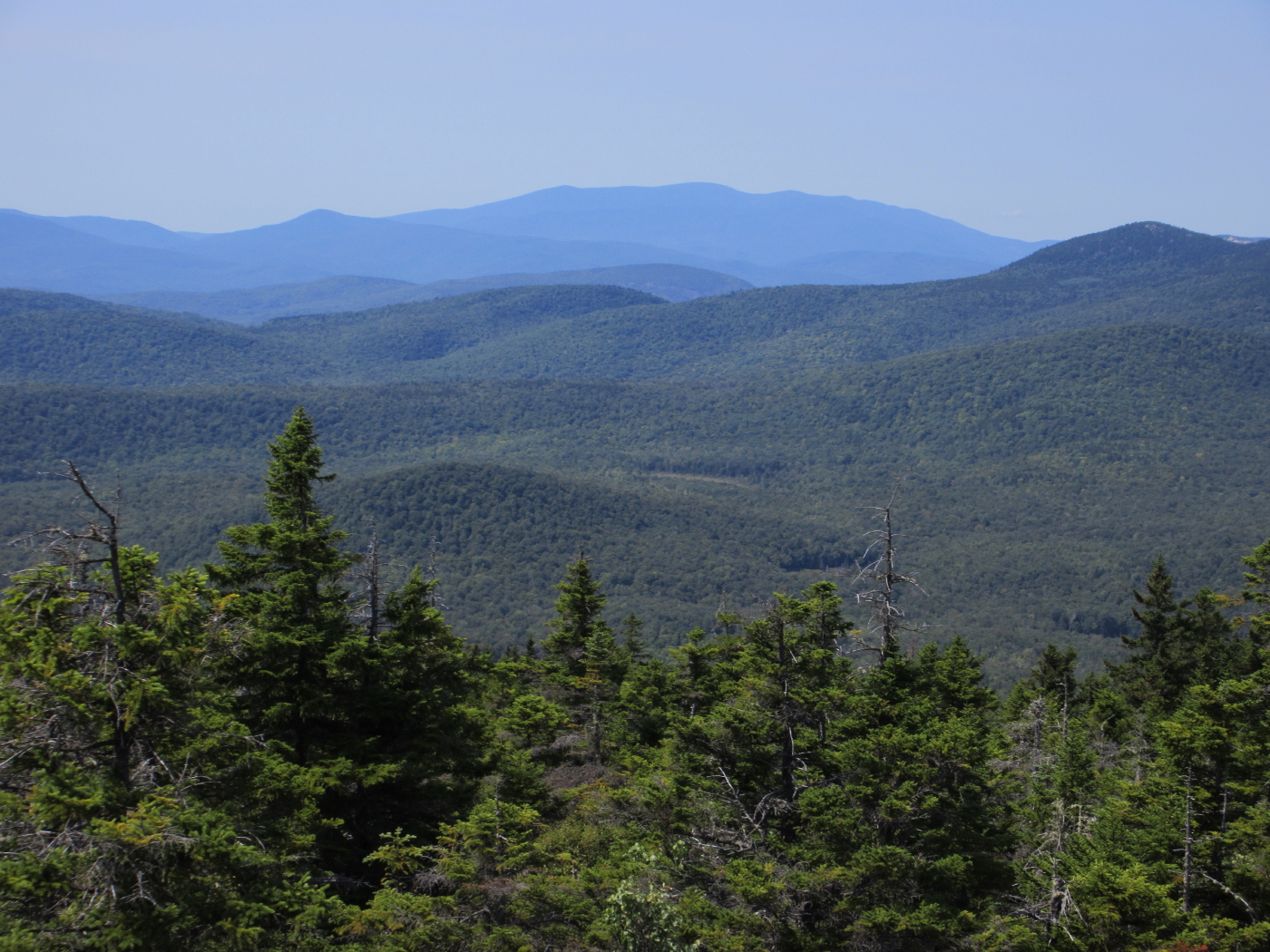
Carr Mountain in the distance.


A quartz dike in the granite.


The ledgy northern peaks of the Benton Range: Sugarloaf, Black and The Hogsback. These are primarily composed of tough, erosion-resistant quartzite.


The fog has dissipated to reveal wide western vistas.


Back down through the mossy conifers.


The lower half-mile, once an old farm road, is shaded by towering oaks.


Out in a privately owned field by the trailhead, I spotted a mother bear and two cubs.


When a car drove by on nearby Page Road, momma rose up to check it out. She did the same when I started my car, and then the three of them took off on a run into the woods.


Thursday, August 25, 2016


 MOUNT ISRAEL: 8/24/16

My brother Drew was up at AMC's Three Mile Island Camp on Lake Winnipesaukee, and we hadn't hiked together for almost a year, so we rendezvoused in Holderness and headed up to Sandwich Notch for a hike up 2630-ft. Mount Israel via the Guinea Pond and Mead Trails. Joining us was Stacie Funt, an AMC member from Long Island, who was also staying at Three Mile. It was an interesting hike with great views and a bit of added excitement.


Drew drove us up the Sandwich Notch Road from Center Sandwich to the Guinea Pond trailhead parking on Beebe River Road. Beyond the Sandwich Town Park the road was very rough, especially the short paved sections, as bad as I've seen it. Not recommended for low-clearance vehicles!

Early on, the Guinea Pond Trail crosses a powerline built in the late 1950s. We crossed it again on the Mead Trail.


Heading into the extensive wetlands along the Guinea Pond Trail, following the grade of the old Beebe River Logging Railroad (1917-1942).


Sprawling Sandwich Dome seen across a beaver swamp. The new bypass created last year around a sometimes-flooded spot on the trail was not needed today, as this stretch was bone dry.


The looming SE spur of Sandwich Dome.


Stacie and Drew getting ready to head up the Mead Trail. Five minutes earlier, we heard a rustling in the woods and then saw a bear cub scampering up a tree trunk. We hustled out of the area before momma made an appearance.


The Mead Trail passes between these twin white ash trees.


Snack break at a brook crossing halfway up the pleasant Mead Trail. A quiet spot deep in the forest.


Pileateds at work.


Lush greenery.


The uppermost section of the Mead Trail climbs through spruce forest. Right above here I took a bee sting in the arm.


Trail junction just below the summit.


Summit smiles!


Israel's ledges are a premier lunch spot.


One of the best views of the Sandwich Range high peaks.


Paugus and Chocorua off to the northeast.


 Massive Sandwich Dome, front and center.


Mount Moosilauke to the northwest, beyond the upper Beebe River drainage.


A peaceful scene along the Beebe River, a short way in on the Black Mountain Pond Trail.


On the way home I took a short walk in on the Col Trail below the Rattlesnakes to visit this beaver pond with a peek at the Squam Range. Here I saw a Great Blue Heron, a group of young mergansers, Cedar Waxwings, and a pair of fly-catching Eastern Phoebes.


Saturday, August 20, 2016

THE LONG WAY TO NORTH PERCY: 8/18/16


THE LONG WAY TO NORTH PERCY: 8/18/16

I joined Greg Ortiz for a long approach to North Percy Peak via a newly-opened 4-mile segment of the Cohos Trail  - the Pond Brook Falls Trail and then the Trio Trail - in the Nash Stream Forest. In the evening I did a second, shorter hike on the East Side Trail. A marvelous area!

We started our hike on the Pond Brook Falls Trail, which leads to its namesake falls in just 0.1 mile. The new section of trail turns left just below the falls, with a spur trail leading up to the broad ledge slabs (slippery when wet).


With its slabs and waterslides, it's sort of like the North Country's version of Franconia Falls.


The new trail climbs up the slope to the left of the falls. This Cohos Trail bog bridge is covered with chicken wire for improved traction.


This seasonal bridge over Pond Brook well above the falls will be removed each autumn and reinstalled each spring.


Pond Brook, looking downstream.


After crossing Trio Ponds Road, we entered the new Trio Trail, the second and longer segment of the new trail route, which was completed within the last couple of weeks.


The SW spur of Whitcomb Mountain seen across an old beaver meadow filled with wildflowers. Cliffs up there look like an interesting bushwhack destination.


For about a half-mile the trail passes by a series of recent logging cuts. This one opens a view to West Peak and and the sharp summit of Sugarloaf Mountain.

Greg spotted two moose up ahead in one of the brushy cuts. These were their tracks.

The trail running across one of the cuts.


As the trail wraps around the lower west end of Long Mountain, it passes through a vast stand of fine hardwood forest.


Great work by the Northwoods Stewardship Center crew and Cohos Trail volunteers who built this trail.


We wondered if this was some kind of old pool, built to provide a water source.


A gorgeous, Catskill-like hardwood glade.


Long Mountain Brook at the trail's crossing.


Lunch break at the Percy Loop Campsite. As the wheel turns, it's 3.9 miles from the Pond Brook Falls trailhead to the Percy Loop Trail.


Kiosk at the campsite. There's an excellent water source nearby.


New signage.


Another new sign.


Unusual blazing. The Percy Loop Trail is now blazed in red, and in both red and yellow above the campsite, where it is part of the Cohos Trail.


A rather gnarly stretch of the Percy Loop Trail on the damp and shady "back" side of North Percy.

Heading up the steep, grippy granite slabs on the cone of North Percy.


The trail is well-blazed on the ledges.


Summit sign.


Looking north up the Nash Stream valley to an array of 3500-ft. peaks. Greg, an avid bushwhacker, has climbed just about every peak, tall and small, in this region.


West to the Goback/Savage Mountain group.


Looking back up at the scrubby summit. There were plenty of blueberries ripe for the picking.


Aptly-named Long Mountain stretches away to the east, with the Mahoosuc Range on the horizon.


Greg stands on the brink where the abandoned West Side Trail came up via exceedingly steep ledge slabs.

Looking down the old West Side Trail route.


South Percy with the Pilot Range beyond.


Walking down into the SE views.


Christine Lake, with the little nub of Victor Head on its left.


The mile-and-a-half section of Percy Loop Trail below the campsite is a delightful descent route - easy to moderate grades, excellent footing, and fine hardwood forest.


Smooth sailing.


After the descent from North Percy, Greg headed home while I drove farther up Nash Stream Road for a three-mile round trip on the East Side Trail, another link in the Cohos Trail.


The trail starts off beside pretty Nash Stream.


A half-mile in, a rough little side path leads down to this interesting feature, named by Cohos Trail founder Kim Nilsen.


A remarkably pointed boulder.


The Devil's Jacuzzi in Nash Stream, a natural tub with built-in jets.


I continued for another mile, up-and-down through fine hardwood forest, to a side path leading down to a spot at the edge of Nash Stream Bog.

This was a 200-acre pond until its dam burst in 1969, flooding and scouring the valley. It's now the largest wetland in the area. Mount Muise (3615 ft.) can be seen to the right.


The trailhead for East Side Trail is nearly opposite that for Sugarloaf Mountain, so if you're making the long 8-mile drive up gravel Nash Stream Road to climb Sugarloaf, a 52 With a View Peak (as is North Percy), the East Side Trail makes a nice easy second hike for the day. Thanks to all the volunteers who have created and maintain the Cohos Trail, a unique and wonderful addition to New Hampshire's hiking trail system!