Monday, December 31, 2012


SNOWSHOEING ON EAST POND TRAIL: 12/30/12

Our friends Harry and Barb Cunningham were up from Concord visiting and wanted to do some snowshoeing in the fresh powder that had fallen the previous few days. One of our favorite trails for 'shoeing is the East Pond Trail, so up the Kanc we went. Ours was the only car in the parking lot, and there was 4" of untouched powder atop an older snowshoe track - perfect conditions!

Up to the crossing of Pine Brook, the trail follows an 1890s vintage J.E. Henry logging railroad grade through corridors of conifers.


The happy snowshoeing couple posed for a photo through a blowdown arched across the trail.


Along the edge of Pine Brook. The crossing here was sketchy, with no real snow bridges formed, so we didn't try to cross.


Instead, we bushwhacked a little ways up the brook, through deep powder.


A scene along the brook.


Pine Brook muffled in new-fallen snow.


A cold blue sky overhead as we returned along the trail. Winter has most definitely arrived!


Friday, December 28, 2012


NAUSET MARSH TRAIL, CAPE COD NATIONAL SEASHORE: 12/26/12

While down visiting family on Cape Cod, Carol and I had the chance to spend part of a beautiful morning on one of the nicest hikes in the Cape Cod National Seashore, leading from the Salt Pond Visitor Center past Nauset Marsh and out to Coast Guard Beach on the Atlantic. We started out on the popular Nauset Marsh Trail, a 1.3 mi. loop with a variety of wetland and upland scenery.


At the start the trail skirts scenic Salt Pond.


A gnarled old red cedar along the edge of the marsh.


From a high point, a view across Salt Pond Bay towards Nauset Marsh.

Lots of fine scenery on this trail.


Halfway along the Nauset Marsh Trail, we turned onto an extension of the trail that leads a mile or so out to Coast Guard Beach. This was a delightful walk through upland forests of oak and cedar.


We stopped briefly at one of Eastham's early homesteads, established not long after the Pilgrims landed. The gravestone in back on the left dates to 1685, though it was actually placed here in the 1860s.


Deer ticks are a major concern for Cape hikers, even during the cold months, though certainly less so than in the spring.


The trail runs along the edge of Nauset Bay, with views across to the Coast Guard Station.


A boardwalk section leading through tall reeds. Winterberry, a type of holly, adds some color to the landscape. The bright red berries are popular for holiday floral arrangements.


The Coast Guard Station was built around 1936, replacing an earlier building dating back to the 1870s. It was in service until 1958. Now the building is used for school groups and other educational programs.


A map of the Cape Cod National Seashore. The story of the establishment of this park in 1961 - under the leadership of President John F. Kennedy -  is a fascinating one. It's unique in that there is much private property within its 43,600 acres, more on the model of a British national park. One shudders to think of what the Great Beach and its adjacent ponds and woodlands would be like today had the CCNS not been created.


Approaching Coast Guard Beach.


Looking south down Coast Guard Beach.


A brisk morning at the edge of the Atlantic.

Looking north along the beach.


From the Coast Guard parking area there's a fine view over Nauset Marsh.


A dream house that has a view over the marsh.


A wonderful winding path with good footing.


Back near the Salt Pond Visitor Center, the Nauset Marsh Trail coincides with the Buttonbush Trail, designed for the visually impaired.


The Buttonbush Trail features a number of interpretive panels with both printed text and Braille. An interesting way to end our 4 1/2 mile Cape hike.


Friday, December 21, 2012


LOWER GREAT GULF: 12/20/12

Cath Goodwin and I went north looking for snow, and we found enough at the Great Gulf trailhead north of Pinkham Notch to enjoy our first snowshoe trek of the season: a six-mile loop on the Great Gulf Trail, Osgood Cutoff and Osgood Trail. Though the cover was only a few inches at the trailhead, it was dense and firm and made for pleasant 'shoeing.


Near the start of the trail we crossed the big suspension footbridge over the Peabody River.


Looking upstream along the Peabody.


Snow garlands decorated some of the branches along the trail.


We made a short side trip to snowy ledges and a cascade on the West Branch of the Peabody, 0.7 mi. from the trailhead.


Cath spotted this winter-blooming witch hazel at the edge of the ledges.


At 1.6 mi. the Great Gulf Trail enters the Great Gulf Wilderness.


A snow-caked corridor along the trail.


At 2.4 mi., another scenic spot where the trail touches the edge of the West Branch. It looked almost mid-winterish in here.


A steep pitch leads up to the gravelly opening known as The Bluff.


Cath scales the big boulder at The Bluff.


The view from the top of the boulder. Despite a forecast for partly sunny skies, it remained murky all day, with dense clouds smothering the ridges above 3000 ft. On a clear day the views from the boulder and The Bluff include Mt. Washington's Chandler Ridge, Mt. Jefferson and Mt. Adams. On this day it looked more like a scene from Finland. (The highest Presidentials did poke above the cloud deck, enabling the Mount Washington Observatory staff to capture some spectacular undercast photos.)


Looking down from the top of the boulder.


We turned onto the Osgood Cutoff, and after a short climb followed a side path to an opening with a unique view up the Great Gulf. Even with the low clouds we could see the shape of this magnificent glacial valley.


On a clear day, the view from this little spot atop an old slide is spectacular, with Mt. Jefferson and its precipitous "Knees" looming on the R.


Then we enjoyed a pleasant meander along the Osgood Cutoff.


Tracings in the snow from a small critter.


A R turn on the Osgood Trail headed us back down to the Great Gulf Trail, completing the loop. The only hikers we met were two barebooting college-age guys who were camping up near treeline on Mt. Madison. We had met them earlier as they were descending to go get a stove malfunction fixed. On our way out we met them on their way back up to their campsite.

It was an unexpected pleasure to get out on snowshoes for the first time this season. Hopefully more snow will come soon to replace that which was washed away by the rain on 12/21.

Happy Holidays to all!


Sunday, December 16, 2012


BALD MOUNTAIN RIDGE/HASELTON BROOK BUSHWHACK: 12/13/12

Taking advantage of bare ground and a sunny, mid-30s forecast, Cath Goodwin and I headed to one of our favorite wild nooks in the White Mountains - the long, trailless ridges and valleys on the SW side of Mt. Tecumseh. I'd been to the view ledges on the lower Bald Mountain ridge (the long SW spur off West Tecumseh) several times before, and knew we would have some fine hardwood whacking partway up the ridge and especially in the Haselton Brook valley below.

Our approach route led through an area of old apple orchards in the WMNF.


After crossing Haselton Brook on a logging road bridge, we started our whack up the Bald Mountain ridge, with easy to moderate grades in open mixed woods, then hardwoods. We came upon this beech with its bark gnawed off at the base. Porcupine, we think.


There were many bear trees in these woods. Cath noticed this particularly striking claw pattern on a beech.


Sunny open hardwoods!


We climbed through an oak grove to our first view ledge on a shoulder, with a framed look SW to the ridges of Carr Mtn.


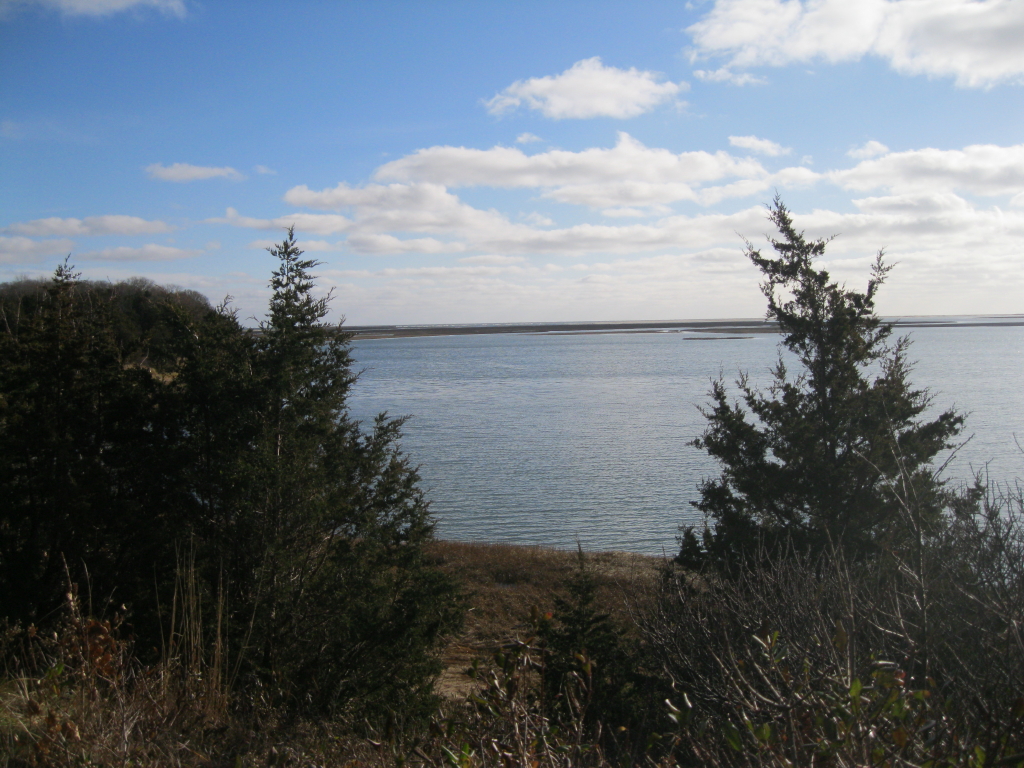
We took a break at a nearby spot with a view of a 3400-ft. peak we call SW Green (L) and Hogback Mtn. (R), both trailless. For a while we watched a Red-Tailed Hawk soar in a circle high above the ridges.


Just beyond the ledgy shoulder was a beautiful hardwood col, a la Catskills.


Another good bear tree.


Heading up an amazingly open slope leading to a steep, rocky climb to the next level of the ridge.


Beech feet with long claws.


Picking a way up the rocky slope.


Up on the next shoulder we found our first wide-open view ledge.


We worked our way out to it and took a nice lunch break in the sun.


The Haselton Brook hardwoods march right up to the base of the cliffs.


Looking up the Haselton Brook valley to SW Green (the rounded peak on the R) and Mt. Tecumseh (the little nubble on the far L).


Across the valley to Hogback Mtn. (L) and Fisher Mtn. (R).


Behind the cliffs, Cath, a professional gardener/landscaper, identified this rock garden as Christmas Ferns. Very appropriate less than two weeks before Christmas.


We popped out on a series of ledges as we continued N along the ridge.


As we whacked along the conifer-clad crest, Cath found a Map Adventures waterproof trail map on the ground, dropped by a previous adventurer. Since there are no listed peaks in this area, we figure visitors are few and far between on this ridge.

Another ledge.


Traversing some rugged terrain.


Varied whacking conditions - some thick, some fairly open.


Around 2:00 we arrived at the prize ledge of the day, at the N end of the lower part of the Bald Mountain ridge. What a great spot in the afternoon sun, gazing across the valley at the remote spur ridges of Green Mountain.


In 1995, shortly after Cath had introduced me to this wonderful area with a climb up Fisher Mtn., she, Cindy DiSanto and I snowshoed to the top of the ledgy shoulder seen below. What a wild spot! This may be what Moses Sweetser called "Spring Mtn." in his classic late 1800s guidebook to the White Mountains. He described three routes to Tecumseh from the Elkins Farm in the Mill Brook valley. One of the routes traversed this valley up to a pair of mineral springs and an accompanying spring house. (We hope to try and find some trace of this on a future trip.) The route then headed up Spring Mtn., which "is capped by a remarkable ledge, whose sides are cut with masonic precision; and on the NE is a long and beautiful cascade and clear fall, where a little rill plunges down the sharp slope."


Looking up the valley to the upper Bald Mountain ridge, West Tecumseh, the valley headwall, and Mt. Tecumseh.


Taking in the view to the S down the valley towards Dickey Notch and the Campton Range.


Before leaving, I took the obligatory boot shot, with my new Cabela Avalanche winter boots (purchased on the recommendation of Kevin Rooney on a Views from the Top thread).


We dropped steeply down from the col just N of the last view ledge, then descended into the Haselton Brook valley through endless hardwoods.


We half-expected a Saw-Whet Owl to be peering out from this hole.


Around 1800 ft. we traversed a wonderfully open sugar maple glade that I remembered from a 2009 snowshoe trek through here with John "1HappyHiker" Compton.


John and I had called it "Hardwood Heaven."


A Pileated Woodpecker had been hard at work.


Cath spotted this "field goal tree."


On the lower part of our whack we followed along attractive Haselton Brook.


A view of the ledgy part of the Bald Mountain ridge, taken from Fisher Mtn. across the valley, with the hardwoods of the Haselton Brook valley well-displayed. It was a great day spent whacking in this quiet, beautiful corner of the mountains.