MOUNT MONADNOCK: 6/27/14
Carol and I enjoyed a great day on one of New Hampshire's iconic peaks. By using less-traveled trails, we saw no one on the way up except at the Halfway House site. We went up via Parker Trail, Cliff Walk, Point Surprise Trail, White Arrow Trail, Monte Rosa Trail, Smith Bypass, and Smith Summit Trail, and down by Pumpelly Trail, Red Spot Trail, Cascade Link and White Dot Trail. What a great mountain! (Thanks to former Monadnock State Park manager Patrick Hummel for inside info on the mountain's trails.)
We left Lincoln at 7 am for the long drive down to Monadnock State Park and started off on the Parker Trail about 10 am. The trail starts by a reservoir with a view of Monadnock across the water.

The park features some nice trail signage.

Most of the 1.2 mi. we did on Parker Trail was at mellow grades with good footing.

There is a small relocation with a new bridge over Ainsworth Brook.

Hunter's Rock, a glacial erratic that was supposedly once used as a deer stand.

On to the Cliff Walk - one of the coolest trails on Monadnock. This ladder is a welcome aid on one steep pitch.

A neat section along a wooded plateau.

Climbing through a luxuriant growth of vines.

A step pitch heading up towards Hello Rock.

Easterly view from Hello Rock, from which guests staying at the old Half Way House would call greetings to hikers ascending below on the Old Toll Road.

The Pack Monadnocks from Point Surprise, the next viewpoint along the Cliff Walk.

Gap Mountain, which I would climb in the evening, seen from Point Surprise. The Cliff Walk ducks back into the woods and breaks out onto viewpoints several more times above here. We left the Cliff Walk here, as my trail-checking agenda required us to descend to the Old Half Way House site via the Point Surprise Trail, one of a number of delightful short paths built by hotel guests.
The Half Way House was a Monadnock landmark for many years. Many guests would return year after year. Here, where we were briefly on the popular White Arrow Trail, we encountered the only other hikers we would see on our ascent.

There had been a relocation of the lower part of Fairy Spring Trail to coincide with Monte Rosa Trail.

Beautiful woods on the Monte Rosa Trail.

"The Tooth," a prominent rock at the junction of the Smith Bypass and Smith Summit Trail, both named for Scott A. Smith, one of the most active trail builders among Half Way House guests in the 1890s.

Markings at the trail junction.

View towards the summit from the top of The Tooth - a fine perch in the warm sun.

Distinctive markings on the lightly-used Smith Summit Trail, a great alternative to the heavily-trampled White Dot and White Cross Trails.

The Smith Summit Trail gave us numerous views as it ascended a series of open ledges. This vista looks back down at the rocky knob of Monte Rosa.

We could see a number of hikers relaxing up on the summit.

Carol led the way up a series of ledge scrambles on the Smith Summit Trail.

C'mon, slowpoke!

Looking west towards the southern Green Mountains. I could see Mt. Snow, Stratton Mountain, Mt. Equinox, Bromley Mountain and others.

This little chimney is the last scramble on Smith Summit Trail.

Of course we had to hike this trail!

A rather festive scene at the summit. Must be quite the circus on a holiday weekend.

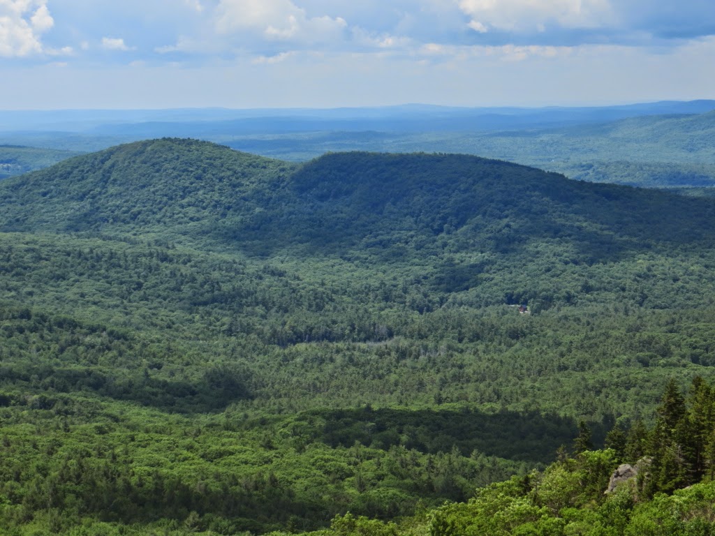
Looking south towards Gap Mountain and Massachusetts. To the SE I could pick out the Boston skyline beyond the Wapack Range.

Pumpelly Ridge, the long northern spur ascended by the Pumpelly Trail.

Looking NW towards Dublin Peak.

Looking back at the summit as we descend the upper Pumpelly Trail.

Leaving the crowds behind!

Big cairn at the Red Spot/Pumpelly Trail junction.

The distinctive markings on the Red Spot Trail.

After an initial easy stretch across broad open ledges, Red Spot was a real butt-kicker of a descent.

A rough bouldery section with awkward footing - slow going.

A final vista east to the Wapack Range before descending into the woods.

After a long mile on Red Spot, we headed back to the trailhead via Cascade Link and the lower part of the White Dot Trail, completing a marvelous loop over the mountain.

We then drove over to the Gilson Pond trailhead, and I made a quick one mile loop around the attractive pond. From the east end of the pond there's a great view of Monadnock, but the glare of the low evening sun precluded any photos.

I finished off the day with a brisk dusk ascent of little Gap Mountain. The SPNHF Gap Mountain Reservation offers ascent routes from the north and south; I came up via the relocated south route, which is 1.3 mi. long with 600-ft. elevation gain. The summit has a notable view of Monadnock.

Sunset over Vermont. Time to head down for the long drive home.