Sunday, October 31, 2021

Pondicherry Wildlife Refuge: 10/29/21


The gentle trails of Pondicherry National Wildlife Refuge in Jefferson and Whitefield, on the north side of the Whites, offer some of the most scenic walking in the Whites. Just what I was looking for after a full trail work outing the previous day. This 6,405-acre tract is technically the Pondicherry Division of the larger Silvio Conte National Fish and Wildlife Refuge. In addition to its scenery, it is noted as one of the top birding locales in New Hampshire. 

For this visit, I chose an approach I hadn't done before: the Slide Brook Trail, a section of the Cohos Trail, starting from the trailhead parking area for Owl's Head Trail on NH Rt. 115. This historic marker, describing the second most notorious slide in White Mountain history (after the 1826 Willey Slide), makes for interesting reading at the trailhead.


It's a short walk along the busy road to the Slide Brook trailhead.

As a fan of walking through fields (during non-tick season), I immediately liked this trail.


From the lower end of this large field, there's a nice view looking back at the sharp peak of Owl's Head.


The long-overgrown track of the 1885 slide can be seen angling down to the left from the peak, then swinging down to the right, outlined by a strip of yellow trees.


This stereoview from Littleton View Co. is titled “Cascade Falls, Cherry Mt. Slide, Jefferson, N.H.” In the aftermath of the tragic fall of the 1885 slide, the scene became a popular tourist attraction. Supposedly this field is where the slide came to a stop. (From the New York Public Library collection).


Farther along the trail passes through a wetland along the top of an old beaver dam.


Slide Brook Trail ends in 0.6 mile at the Presidential Rail Trail, where you turn left to follow the latter for 2 miles to Cherry Pond. Moorhen Marsh is one of the scenic highlights along the way.


Just 50 yards or so along the rail trail a bridge over Stanley Slide Brook offers a good view of Mts. Starr King and Waumbek.


This section of the rail trail was resurfaced in 2020 and offers excellent walking and bicycling.


In the middle of the expansive Moorhen Marsh, 1.5 miles from the Slide Brook Trail, a bench invites for a break in the sun.


The Presidentials are the highlight of the sweeping view here.


Owl's Head and Cherry Mountain rise to the south, their bases lined with aspen and tamarack gold.


Late October is tamarack foliage time around these wetlands.


View of the Pliny Range across Cherry Pond from the Tudor Richards Viewing Platform, dedicated to legendary NH ornithologist and naturalist Tudor Richards, who was instrumental in creating the refuge.


The Presys underlined with tamarack foliage.


A watery Presy view from the Shore Path along the edge of Cherry Pond.


Another angle on Owl's Head/Cherry Mountain.


The Little Cherry Pond Trail is a wonderful ramble through boreal forest. The plank walkways in this area are covered with chicken wire for better traction.


There are no mountain views at Little Cherry Pond, but the place has a wild, primeval feel.


Tamarack foliage at Little Cherry.


Another Presy view on the return walk.


Late afternoon light on the Presidential Rail Trail.


Last sun on Starr King & Waumbek.


Saturday, October 30, 2021

Passaconaway Cutoff: 10/28/21

I lucked out with a fine sunny late October day for some fall maintenance on the Passaconaway Cutoff, the adopted trail of the AMC Four Thousand Footer Committee. It was 27 degrees at the start but warmed up into the high 40s by afternoon.

A new signpost has elevated the signs at the junction of the Cutoff and Oliverian Brook Trail. On this trip I used a long-handed garden hoe for cleaning drainages as a number of the rock waterbars on the Cutoff have narrow channels. The smaller head of the garden hoe works better on these than the larger head on my hazel hoes. And the long handle is easier on the back when pulling heavy wet leaves.


Lovely hemlock forest on the lower part of the Cutoff.


A golden October day in the hardwoods above the crossing of the west branch of Oliverian Brook.


With the leaves down, Mt. Passaconaway is a looming presence as the trail climbs above the brook.


Today I tried a new pattern for the work - clearing blowdowns (only 4) and doing some brushing on the way up, and hitting the major part of the work - cleaning drainages - from the top down. I knew I wouldn't get to all 57 drainages and decided it would be best to leave just the lower ones for another trip with the shorter daylight hours. Usually I do all the work from the bottom up.


Blowdown cleared.


From the top of the Cutoff I headed 0.3 mile up Square Ledge Trail to the Nanamocomuck Slide for lunch with a view, stopping briefly to poke around an old logging camp site of the Swift River Railroad along the way.


I hadn't seen these artifacts before. Please remember that these are protected by law and should not be disturbed or removed.


The Square Ledge Trail passes along the bottom of the Nanamocomuck Slide.


A short, careful scramble up the right edge leads to a shelf with a fine view to the north. Hedgehog Mountain and the East Ledges are prominent in the foreground. Mt. Tremont and Bartlett Haystack are in the middle distance. Mt. Washington and the Wildcats/Carters are on the horizon.


Looking up the slide from the shelf. This slide came down during the 1938 hurricane. The crumbling ledges make for tricky footing.


A well-weathered trail sign at the top of the Cutoff.


A break in the trees reveals the mighty Passaconaway.


In the afternoon I cleared 40 drainages on the way down, leaving just 17 for a second trip. Lots of wet leaves after a rainy couple of days.


Cascade on the west branch of Oliverian Brook.


Saturday, October 23, 2021

2021 White Mountain Crop Hunger Walk: Rattlesnake-Squam Range Loop

 On Friday, October 22nd four of us enjoyed a cool, cloudy fall day (with a bit of sun) for the 33rd annual White Mountain Crop Hunger Walk, a "hike for hunger" that benefits the programs of Church World Service. This year's participants included Thom Davis, Roger Doucette, Gary Tompkins, and this correspondent. We missed Dennis Lynch and Mary Ann McGarry, who weren't able to join us this year. Our route was a 10.8 mile loop in the Squam Lake area, taking us over West Rattlesnake and the Squam Range peaks of Mt. Morgan, Mt. Percival, Mt. Squam and Doublehead Mountain. Trails walked included the Col Trail, Ridge Trail, Old Bridle Path, Mt. Morgan Trail, Crawford-Ridgepole Trail, Doublehead Trail and the new Eastman Brook Trail.

The Church World Service CROP program began in 1947 and the first CROP Hunger Walk was held in 1969. Each year walks in more than 500 communities raise more than $6 million for CWS hunger programs. For more information see www.cwsglobal.org.

Ours is the only Crop Hunger Walk that takes place on mountain trails. Since its beginning in 1989 our walk has raised more than $93,000 for the anti-hunger programs of Church World Service, with more than $23,000 of that provided to local food pantries in the western White Mountains. We owe the success of our walk to the consistent generosity of our sponsors. The CROP Hunger Walk theme is “Ending hunger, one step at a time."

To make a donation for our walk, visit events.crophungerwalk.org/2021/event/lincolnnh , or mail a check made out to "Church World Service" to Steve Smith, PO Box 485, Lincoln, NH 03251. Thanks!

 Heading out on the first trail of the day, the Col Trail leads us up to the saddle between West and East Rattlesnake.


Ascending the Ridge Trail to West Rattlesnake.


Gary takes in the scene atop West Rattlesnake as fog swirls over Squam Lake.


The summit of West Rattlesnake is a Natural Area owned by the University of New Hampshire.


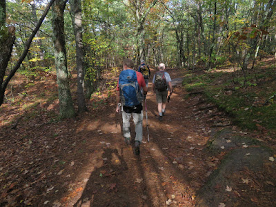
Descending the extremely popular Old Bridle Path.


Across the street, some nice color on the Mt. Morgan Trail.


Staircase on upper part of Mt. Morgan Trail.


Junction with the alternate "ladder route" up to the summit ledges of Morgan. 


Gary was up for the challenge of this "Terrifying 25" route. The rest of us went around on the main trail.


Gary takes in the Squam Lake view from the Mt. Morgan ledges. Great place for a long lunch break.


An obliging hiker took the traditional group photo for us.


Thom checks out the Museum of Science benchmark on the true summit of Morgan.


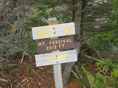
A 0.8 mile walk along the rugged, ledgy Crawford-Ridgepole Trail brings us to the open summit of Mt. Percival.


Part of the fine view from Mt. Percival.


Summit signs.


Leaving Percival, heading north on Crawford-Ridgepole Trail towards Mt. Squam and Doublehead Mountain.


The northern half of the Crawford-Ridgepole Trail is surprisingly rugged. From a distance it appears as a long, flat ridge with a few insignificant bumps. But it has many short, steep ups and downs, often involving rugged ledges with awkward and slippery footing. These are true mountain miles.


Blueberry color.


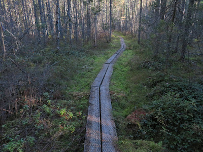
This section of Crawford-Ridgepole Trail is wild and lightly-traveled.


Some of the countless knobby ledges along the ridge.


Steep ledge at the east summit of Mt. Squam.


Roger checks out the ledgy pools known as Uncle Paul's Potholes.


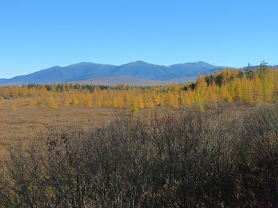
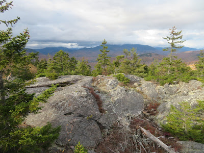
In this area there are good views north to the Sandwich Range. On this day the peaks were smothered in dark clouds. Our original plan for the Crop Walk was a loop over the Crescent Range in Randolph, but with a gloomy and potentially wet forecast for the North Country we opted for our more southern backup route. Seeing these ominous clouds to the north, we agreed that we had made the right choice.


Another nice vista along the Crawford-Ridgepole Trail.


The very steep, ledgy drop to the Squam-Doublehead col is one of the most challenging spots along the trail.


Looking up from the bottom of the down-scramble.


Onto the Doublehead Trail for the descent off the ridge.


The best viewpoint on Doublehead - and one of the finest on the entire Squam Range - is a big ledge 0.1 mile down off the ridge on the Doublehead Trail. After a steep descent below the ledge we continued down Doublehead Trail to gravel Thompson Road. A short stroll along the road brought us to the Eastman Brook Trail, a new 1.2 mile connector opened in 2020 by Squam Lakes Association. We negotiated this meandering route by headlamp back to our vehicles at the new parking area off Rt. 113, and another great Crop Walk was in the books.