One of the newest large slides in the Whites fell into Dry Brook Ravine off the west ridge of Little Haystack, during the "Halloween Storm" of October 2017. The upper half of it can be seen on the right in this view from an outlook along the Old Bridle Path.
I snowshoe-bushwhacked in to visit this slide last winter, and went halfway up, partly in the woods. The upper half looked dauntingly steep.
I wanted to revisit this slide in summer, in part to see how revegetation was progressing 4 1/2 years after it fell. If the terrain of the slide permitted, I hoped to climb to the top and exit to the Falling Waters Trail.
I reprised my winter approach route and whacked partway up the west ridge of Mt. Lincoln (aka Carpenter's Ridge), weaving through nice hardwood forest in the lower part.

Higher up on the ridge there was much blowdown to maneuver around.
I sought out an old logging road I had used on the winter trip, and followed it farther into the ravine.
Eventually I dropped down to a lower logging road, followed it briefly, then made a steep descent to Dry Brook on the floor of the ravine.
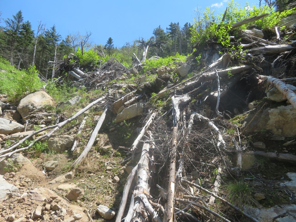
As I remembered from the winter trip, there was a mess of blowdown to navigate before heading up the floor of the ravine.
A nice corridor beyond the blowdown.
After a while I took to the brook itself as the route.
I soon came to the rocky lower track of the slide, where the brook goes underground. This track runs out for 0.2 mile from the base of the slide itself.
At several points there were glimpses ahead to the craggy headwall of the ravine.
A course of destruction was evident all along the edges of the track.
A mini-gorge.
Approaching the base of the slide, with the Dry Brook amphitheater rising above.
Zoom on the Gargoyles (or Pinnacles) of Mt. Lincoln.
The chaotic scene here is being softened by fresh green vegetation, primarily little saplings of white birch, most likely the heart-leafed variety at this high elevation (3450 ft.)
This is a "deposit area," where soil and debris was dumped as the slide slammed into the brook drainage and made a hard left turn downstream. In his seminal 1958 study of White Mountain landslides, Edward Flaccus noted that revegetation was rapid in these deposit areas, while ledge and talus areas could remain bare for many years. In a survey of 22 slides, he found paper birch, a "pioneer tree," present at every one.
Paper birch leaves.
Red-berried elder, a frequent denizen of slides, was thriving at the edge of the deposit area.
A view down the valley to the Kinsmans.
I next turned my attention to the slide, rising steeply, high onto the ridge.
The ledges on the upper slide were gleaming with water runoff, and some looked very steep. I had my doubts about being able to climb through these rocky steps.
I headed up the lower part of the slide, at first on the compacted bank to the right rather than the loose gully to the left.
Farther up, the terrain nudged me into the gully.
Looking down the gully.
I used a sort of wedge move to get up this hard-packed cut at the top of the gully section.
I emerged on the wider, ledgy middle section of the slide.
The first of many steep ledge slabs, most of which could be skirted one way or another.
Cannon Mountain hove into view.
Upward through the ledges.
Getting steeper.
The slide offered continuous views up to the craggy crown of Mt. Lincoln.
Some climbers call this Guy's Slide, in honor of the late Guy Waterman, who climbed it in the 1970s. Descriptions suggest that rock climbing skills are needed to ascend this slabby swath.
A natural staircase eases the way.
Oh, my.
Bulging ledges.
I took a long break here to admire the scene. The Old Bridle Path ridge was now in view and in the distance were the Jay Peaks and other mountains in northern Vermont.
Down-look.
Cannon Cliffs and outlooks on Old Bridle Path.
I have long eyed this slide high on Carpenter's Ridge. Not sure if I could climb it from below, maybe just whack to the top from above.
Hikers approach the summit of Mt. Lincoln.
Continuing up, I came to the first of a series of very steep headwall ledges.
That is beyond my skill level.
Looking across at Mt. Lincoln.
Time to take to the woods....
...which were decidedly unfriendly. Thick, steep, every step contested.
I wrestled my way back out to the slide just below the top.
Greenleaf Hut was now in view.
Typical steep slide headwall.
Nope, not going up that.
Yikes!
Into the woods on the other side.
Top o' the slide, at ~4000 ft.
More Type II fun.
The rocky Falling Waters Trail is not one of my favorite descents, but I was mighty happy to reach it.
Cloudland Falls, the #1 attraction of FWT. Good going from here on down.


Remarkable journey! Nice to see Bridal Path framed by Cannon mtn.
ReplyDeleteHoly cow. I could imagine there still being dust in the air from when the whole thing first collapsed!
ReplyDelete