A cold day with persistent snow showers provided the setting a for snowshoe adventure into the ravine of the south branch of Walker Brook, on the NW side of Mt. Lincoln. I ascended to 4300+ ft., almost to the icy chute of Lincoln's Throat. It was a remarkable experience, though I must confess I didn't fully earn it as a fine packed track left by backcountry skiers made it much easier to access the open slide swath of the upper drainage. I did earn some extra (sunset) views with a side trip breaking trail up onto a slide on the north side of the ravine. The ravine is well-displayed in this view from North Kinsman.

After hiking 1.2 miles up hard-packed Old Bridle Path I bushwhacked down a steep slope to the floor of the ravine, where I found the aforementioned skiers' track. This part of the route follows an old logging road through nice open woods. So far the day was sunny, but that would soon change.
Emerging alongside Walker Brook.
Heading up the south fork. This was my third trip snowshoeing in this ravine, but the first time I'd gone more than a short way up the south fork. With warmth and heavy rain in the forecast, I figured this was the time to try it. I lucked out with the packed track, which may have been initially set by climbers in snowshoes headed in to climb Lincoln's Throat - hard to tell. I stepped lightly in my snowshoes to preserve the track, though probably a moot point after the rain.
There's a section of tedious travel on the lower part of the south fork, weaving around boulders and holes with some sidehilling.
Low bridge.
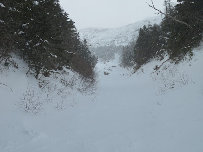
Slides in sight ahead!
Below the open slides the drainage is brushy in places, with many alder thickets.
Snow showers had moved in, obscuring early views back to South Kinsman.
Only a few open water spots were showing higher up in the drainage.
This is a low angle climb up until the first slides are reached.
Luckily, only once did I punch through to the small brook below, gaining a snowshoeful of slush.
At 3400 ft. I reached an open slide on the right (south) side of the ravine.
I went a short way up, but the snow seemed a little sketchy and there wouldn't be any views anyway.
Back to the main track to continue up.
Lots of slidey terrain in here.
A major fork at 3650 ft. The left fork leads to the upper part of a large slide from 1927. The right fork leads up to Lincoln's Throat.
Gateway on the right fork. Getting steeper. The firm windpacked (and in places skipacked) snow with a thin layer of powder on top made for good snowshoe climbing. Avalanche danger rated Low today.
Looking back.
Heading up the long open chute. Probably about a 30 degree slope on average up here.
Zoomed. With conditions good, I hoped to make it up to the fork visible several hundred feet higher.
Wide open.
Approaching the fork at 4250 ft.
Skier's view.
This boulder at 4310 ft. was my turnaround point. It was cold (about 5 degrees) and windy, and from studying the Lidar 2-foot contour map I knew there were steeper pitches ahead, which might be uncomfortable to descend.
In this view from Old Bridle Path, my turnaround point was a short way up the left fork high up under the summit of Mt. Lincoln. As slides do, it looks impossibly steep when viewed head-on.
Steep enough for me!
Close by to the south rose the striking ledgy west spur of Mt. Lincoln known as Carpenter's Ridge, with the faint orb of the sun above.
A zoom on Lincoln's Throat - a well-known ice climb in winter and a tricky rock scramble/climb in summer.
As I headed back down, the sun briefly emerged....
...lighting up the alpine amphitheater at the head of the ravine.
The Old Bridle Path ridge came into view below.
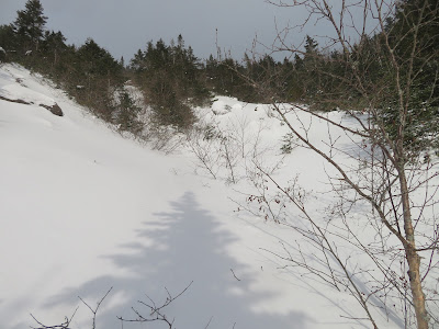
Scouring by slides.
Slowly and carefully descending to the 3650-ft. fork.
Here a trail-like corridor provided a route up to slides on the north side of the ravine.
The snow was deep and unconsolidated here. These views would be earned!
Several slide tracks converge here.
Tough sledding.
Skies are clearing - gotta get up there for some views.
The upper ridge in sight.
The slide widens out. Took more than a half-hour to gain 150 ft. of elevation.
I believe this is the the "sunless gorge" on the west ridge of Mt. Lincoln descended in 1880 by AMC explorer Charles E. Fay and a companion, and described in Appalachia. Lincoln climber Chuck Woodman and a friend ascended this in April 2019.
Alpine vista.
And, finally, the clouds lifted from the Kinsmans.
Yikes!
Golden mist veils the Kinsmans.
Descending into a ball of fire.
Looking back.
Mount Doom.
Afterglow.
Following my tracks back to Old Bridle Path for a moonlit descent.


Makes me think of Guy Waterman, climbing these peaks from so many angles
ReplyDeleteHi Paul, Guy spent a lot of time in this area!
Delete