
Rain/thaw and refreeze had set up the first good, firm bushwhacking snow of the season. On a warm almost spring-like day I headed to the Lafayette Brook Scenic Area. Endless open woods and four viewpoints on the ridge north of Lafayette Brook make this a favorite snowshoe bushwhack.
The Governor Gallen Memorial Bridge (formerly a highway bridge for US Rt. 3) offers a great view of Mt. Lafayette rising above the Lafayette Brook valley. The ridge I ascended to the viewpoints is on the left.

Open hardwood and birch right from the start.

The only spruce trap I fell into all day.
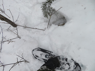
Firm snow - no sinking into bottomless powder today!

This large opening in the forest is a birch graveyard.

Twisted tree.

Tracks.

Beautiful open glade.

Well-preserved nest.

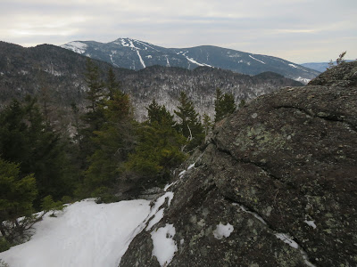
A steep descent through dense brush brought me to the day's first viewpoint, opening a wild view up the valley.

Looking across the valley to the wooded backside of Eagle Cliff.

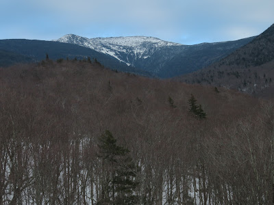
Zoom on Lafayette at the head of the valley. One of the earliest accounts of using a slide as a pedestrian route on a peak - in this case for descent - was written by geologist and Amherst College President Edward Hitchcock in the American Journal of Science and Arts. In August, 1851 Hitchcock and two companions climbed Mt. Lafayette by a “very wretched footpath.” As they descended from the summit, down to the right of the path Hitchcock spotted “the commencement of a slide; and the large amount of rock laid bare at its upper end, incited a desire to visit the spot.” The trio descended the slide, at first down a “mass of naked gneiss rock” that was “steep and smooth.” Hitchcock estimated the slope near the top to be 38 degrees. Farther down they navigated loose piles of debris along the edges, or the dense scrub behind. Along the way Hitchcock noted both lateral and terminal moraines of debris. Below the slide they followed the brook for several miles, hoping it would bring them near the “Notch House Hotel” where they were staying (presumably the Lafayette House, located near the base of Eagle Cliff). But they missed their mark and ended up three miles past the hotel at a farmhouse, whose occupant gave them a ride back to their lodging. Although historic sources suggest that this slide was in Walker Ravine, based on that route, it seems likely the slide was instead located in the Lafayette Brook ravine. Traces, perhaps, of that ancient slide can be seen here on the right side of the valley headwall, under the main summit of Lafayette. Hitchcock later learned that the slide had fallen in June, 1850, “in consequence of a powerful shower of rain.”

From here I had a good look at the uppermost ledge I would be visiting.

Circling around to the north side of the ridge, I came upon some old ski tracks. Shortly after that there were fresh snowshoe tracks, which I would follow off and on the rest of the way up. The solo snowshoer looped back down via a different route so we never met.

Looking out to the NW from another birch glade. The birches are the legacy of a 1903 forest fire that burned 3,000 acres in this area.

At 2900 ft. I meandered through one of my favorite birch glades.

Even after the thaw, there's a respectable snowpack up here.

Open corridor followed by skier and snowshoer.

Postholing moose.

Open woods persist at 3100 ft.

Bare rock on the ledge! A great perch.

Nice view back down the lower Lafayette Brook valley and out to Vermont, with a number of Green Mountain peaks visible on the horizon..

Cannon Mountain behind Eagle Cliff.

Eagle Pass.

The summit of Lafayette just peers over the next bump on this long ridge.

How often can you do this in February? After layering up, I spent a comfortable hour hanging out on the ledge.

Heading back down through the birches. With temperatures in the high 30s, the upper layer of snow was becoming wet and soft, but thankfully the base held firm.

Scene along the ridge.

On the way down I visited two more ledges hidden in rough, spruce-thick terrain along the crest of the ridge. This one has a nice perspective on Lafayette buttressed by its massive western shoulder.

Typical terrain in this area.

The last ledge of the day provided a fine profile of Cannon behind the Eagle Cliff ridge.
Descending steeply off the crest.

Late afternoon view of Lafayette from the bridge. One of the neatest roadside vistas in the Whites.

No comments:
Post a Comment