
In 40+ years of hiking in the Northeast, I had never set foot on any trails in the Berkshire region of western Massachusetts. Carol and I headed down to North Adams for a quick two-night getaway, and while she went on a geocaching spree- making finds in 16 different towns - I took the opportunity to climb Mount Greylock, at 3491 ft. the highest peak in the Bay State. The mountain has a long and interesting history, with Hawthorne, Thoreau and Melville among its famous visitors. I made a long loop from the major trailhead on the western side of the mountain.

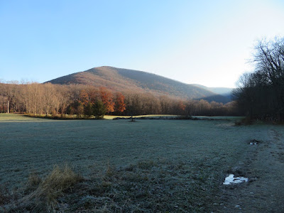
The Hopper Trail starts out with a scenic walk between the fields of the Haley Farm, with a view of Mt. Prospect, a northwestern peak of the Greylock Range.
The Hopper is a unique multi-pronged glacial valley carved into the western flank of Mount Greylock. The ravine's unusual name comes from its resemblance to a grain hopper. It is the jewel of the 12,500-acre Mount Greylock State Reservation.

Morning light illuminates the depths of The Hopper.

Field and mountain - a classic Berkshire scene.
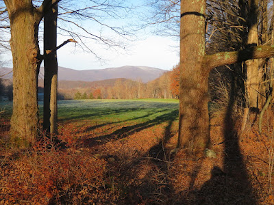
As it leads into the valley, the Hopper Trail passes through a gorgeous open hardwood forest. This trail was originally opened in 1830 by students from nearby Williams College.

The trail steepens as it climbs higher in the ravine.

With the leaves down, the steep wooded walls of the ravine loom large.

I had considered climbing a narrow slide in the south lobe of The Hopper, but looking at it across the valley I could see that the footing would be snowy and icy - too sketchy in such steep terrain on a raw November day.

The woods were snowy above 2200 ft.

Higher up it was quite wintry.

The Hopper Trail meets the Appalachian Trail about a half-mile below the summit.

The AT skirts a small pond that was created by the Civilian Conservation Corps to supply water for the Bascom Lodge at the summit.

The section of the AT leading up to the summit presented some nasty ice flows. With careful foot placement, I made it up without donning my 'spikes.

The 100-foot high War Memorial Tower, originally built in 1932 and restored in 2015-16, crowns the summit of Greylock. It was built using granite from the Quincy Quarries. The ascent via Hopper Trail and the AT is 4.1 miles with 2400-ft. elevation gain.

The partly sunny forecast didn't pan out today, so the views were muted. The large open area at the summit faces east, where the vista is not very mountainous.

Mount Monadnock is one of the most prominent features of this eastern view.

A view panorama IDs the peaks.

On the north side of the broad summit, by the large parking lot for the summit roads, is the CCC-built Thunderbolt Shelter.

Looking north over Mt. Fitch and Mt. Williams, the northern peaks of the Greylock Range.

Bascom Lodge, owned by the state, was built in the 1930s and offers lodging and meals in summer and early fall. For a number of years it was managed by AMC. It is now operated by a concessionaire.

To avoid descending along the icy upper trails, I strolled down the Rockwell Road (closed for the winter) for a couple of miles. It was snowy and in places icy up high, with more bare pavement lower down. The tire tracks are from Mass. DCR rangers checking in on the summit.

The northbound AT descends steeply after crossing the road.

Ragged Mountain is a lower eastern spur of Greylock. Would love to check out the ledges on the two bumps to the right, one of which is accessible by trail.

Wide views SE along one section of the road.

From another outlook along the road, a fine view of the Taconic Range to the west.

The next leg of my nearly 11-mile tour followed gravel Sperry Road (closed to vehicles at all times) past a series of nice-looking primitive, walk-in campsites, to perhaps the mountain's finest viewpoint, Stony Ledge.

I had read that the close-inview of The Hopper on Greylock's massive western flank is considered one of the finest vistas in the state. Even on a grey November day, it was magnificent.

Peering into the north lobe of The Hopper and the valley of Money Brook, so named, supposedly, because 19th century counterfeiters hung out there. The summits, L to R, are Mt. Prospect, Mt. Williams and Mt. Fitch.

The southern lobe of The Hopper, with Saddle Ball Mountain, second highest in the state, on the right.

On the left is the slide I was eyeing. In the center is March Cataract and a long string of cascades below.

I descended from Stony Ledge via the Haley Farm Trail, passing this NW vista along the way.

Beautiful hardwood forest abounds on the lower mile of Haley Farm Trail. I thoroughly enjoyed this initial exploration on Greylock, and would like to return and walk more of its extensive trail network, climb the Hopper Slide, and perhaps take a close-up look at the monstrously steep slide on the east side of the mountain.


Nice report Steve, and glad to see that you enjoyed your first trip to Greylock. The White Mountains are my favorites, but the Berkshires are beautiful too, in a more subtle way. I've done that western route to Greylock, and it really is nice. The trailhead area reminds me a bit of Ferncroft. Like you, I would like to explore some of the other routes too. There is some excellent hiking in the southern Berkshires too, near the CT and NY borders.
ReplyDeleteThanks, BC. I really enjoyed this hike and it is indeed a Ferncroft-like trailhead. Would definitely like to hike more on Greylock. And we'll likely spend some time in the southern Berkshires as well - Everett, Alander, Monument and others all sound like good hikes.
ReplyDeleteGreat report Steve. That region appears to be a bushwhacking paradise.
ReplyDeleteLooking at the Caltopo aerial topo hybrid of the pond you visited, and the adjacent, and couldn't believe my eyes. Thet both appear to sit on a significant slope in a valley, with multiple 20' contours crossing them.
Survey error? Any comments appreciated.
Thanks - it sure looks like the contour lines are off. The ponds look, on the ground, as if they are on a shelf with a good dropoff to the east. Would be interesting to see them shown on a Lidar contour map.
Delete