Carol and I enjoyed a sunny, breezy geocaching hike on the iconic peak of west-central New Hampshire. With a crack o' noon start, we ascended via the West Ridge Trail, the easiest and busiest route up Cardigan. Our ascent was leisurely, with nine geocaching stops along the way.
Cliff's Bridge, which spans a tiny stream.
Breaking into the open on the upper part of the trail.
Ascending the mountain's vast granitic ledges, bared by an 1855 forest fire.
Looking out to Smarts Mountain and Mount Cube.
Into the great wide open.
Approaching the summit fire tower.
Prominent veins cutting through the bedrock, vast horizons beyond.
Cardigan has that top-of-the-world feeling.
Hikers taking in the view towards Firescrew, Cardigan's northern spur, and distant Mount Moosilauke.
Northern vista.
A busy summit, even on a Thursday.
Important junction of West Ridge Trail and Clark Trail near the summit. Their two trailheads are 35 miles apart by car.
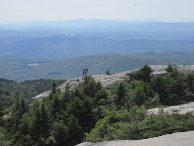
Hikers on a Cardigan crag.
Hikers descending steep but grippy ledges on the Clark Trail.
Long views to the south.
Carol makes her way down the ledges.
We headed along the ridge on the scenic South Ridge Trail, enjoying this view back to Cardigan's summit from the South Peak.
This ledge just off the trail had a fine vista across a valley to Orange (Gilman) Mountain.
Along the South Ridge Trail.
Hanging out on the ledges of Rimrock, with wide western views.
The trail junction at Rimrock. Skyland -- what a wonderful name for a ridgecrest trail.
Nice woods on the Skyland Trail, descending back to the West Ridge Trail. From there, we descended a mile to complete our mellow 3 1/2 mile loop (1300-ft. elevation gain), with a total of 12 geocaches found.


No comments:
Post a Comment