
Took two days off to enjoy some slide bushwhacking and near-peak foliage viewing.
The first trip was a return visit to the big SW Slide on Mt. Osceola. I enjoyed some nice foliage walking along Waterville Valley XC ski trails on the approach to the whack.

Eventually I emerged at the base of the massive, steep and wet "footwall" at the base of the slide. This has to be circumvented to access the rest of the slide above.

This slide actually has two forks. The left and more prominent fork was triggered by Hurricane Carol in 1954. The smaller right fork is an older slide, date undetermined.

Looking across the left (1954) slide to the very steep footwall of the right (older) slide.

These steep wet slabs are not safe to climb. Gravelly patches and dry ledge spots provided upward passage. In a 1958 study of White Mountain landslides and
their revegetation, Edward Flaccus measured the slope of this slide as
29 degrees on the average with a maximum of 34 degrees.

About 2/3 of the way up the slide I headed NE into the woods, hoping to visit the edge of the older slide on the right fork. I came to the base of a ledge swath and circled around to its top and found a fine view to the SE. Only when I got home that evening and looked at Google Earth did I discover that I had not reached the right fork slide, but instead had visited a mini-slide in between the two forks!

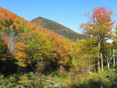
Rich color in the hardwoods at the base of South Tripyramid.

I came back to the main slide about 3/4 of the way up and found a nice ledge seat to hang out on for a while.

Around 2:15 the sun promised by the weather folks finally made an appearance.

Tripyramids, Sleepers and Whiteface.

A view up to the Osceola summit ridge as I carefully descended the slide.

Looking down. This was one of six slides unleashed on Mt. Osceola by Hurricane Carol. After the storm cleared, “the great wounds on the sides of Osceola startled Valley inhabitants,” wrote Waterville historian Grace Bean in The Town at the End of the Road, published in 1983. “Groups of guests immediately set out to explore the scene at close range, as undoubtedly had been done on the occasions of previous slides, and they found enormous piles of rocks, uprooted trees, mud and sand heaped in wild abandon along the gash cut down the mountain.”

Afternoon sun on the footwall of the right fork slide.

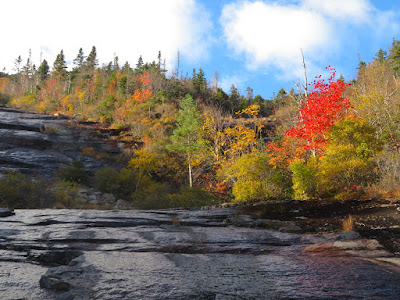
Colorful stripe along the edge of the slide.
The next day I headed into the Sandwich Range Wilderness on the Sabbaday Brook Trail to pay a visit to the 2011 Irene slide on West Sleeper. Unusual for White Mountain slides, this one is lined with mature hardwoods, promising a colorful accompaniment to the impressive gravelly swath.

What a pleasant surprise to run into fellow whacking enthusiast Bill Robichaud at the spot where I was striking off into the woods to head for the slide. I knew Bill was planning on heading into Sabbaday in the near future, but didn't know when, and it was a stroke of good fortune to meet him at that very spot.

We passed through some glorious hardwood glades (though amply supplied with hobblebush) as we made our way into the tributary valley that holds the slide.

Magical.

There's the runout from the slide, which carried quite a distance downstream.

Vegetation is reclaiming the track, much more so than on my last summer visit five years earlier.

A view of the Fool Killer, from the high bank where the slide slammed into the streambed at a right angle.
The West Sleeper Slide, robed in its autumn finery.

Deer tracks on the slide!

The view NE from the wide lower part of the slide. Potash Mountain and "South Potash" in the foreground right. Mt.Tremont and Bartlett Haystack in the middle distance left. Carter Dome and the Baldfaces in the distance.

Bill takes it in. It was a fine day to relax for a while in the October sun.

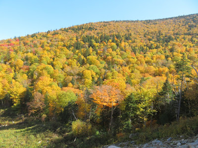
Gold-hued spur ridge of East Sleeper.
Zoom on the Potash peaks, with a bit of the Sabbaday Brook valley below.

Looking up the slide, which tops out several hundred feet above.

Colorful fringe.

Down-look. One of the steepest pitches is near the base.

One of the goals for this visit was to check on the progression of revegetation here. Five years earlier this debris deposit shelf near the base of the slide was populated mainly with pin cherry. Now a vigorous young growth of mainly balsam fir is springing up. In a few years this will be quite a thicket.
.

Back down the valley through the hobblebush.

Artifacts at a logging camp site in the main Sabbaday Brook valley.


No comments:
Post a Comment