
On a glorious sunny, balmy October day, I hiked a great loop over Mt. Whiteface via Dicey's Mill Trail, Rollins Trail and Blueberry Ledge Trail. I checked out some recent improvements on the Dicey's Mill Trail and a short relocation on Rollins Trail. Several viewpoints revealed stunning peak foliage in the hardwood depths of The Bowl, the glacial cirque enclosed by Mt. Whiteface, Mt. Passaconaway and the Wonalancet Range.
The classic view by the expanded Ferncroft parking areas, featuring Mt. Whiteface and Mt. Wonalancet.

Heading through the field on the lower part of Dicey's Mill Trail. We hikers owe gratitude to the landowners who allow access through these beautiful properties.

Mt. Whiteface, the day's ultimate destination.

A fine place to spend the day.

Dicey's Mill Trail is one of the finest of many trails maintained by the Wonalancet Out Door Club (WODC). It is a well-constructed trail with many rock waterbars and stone steps.

Beautiful mature hardwood forest as the trail approaches The Bowl Research Natural Area, where there is a significant stand of old growth forest,

Passaconaway Brook, which is the east branch of the Wonlancet River.

Inviting turn with rock steps well up on Dicey's Mill Trail. This is one of the oldest trails in the Sandwich Range, dating back to 1891, when it was cut by local residents working with Charles E. Fay of the AMC.

This summer and fall major improvements were made to the upper section of Dicey's Mill Trail - from the Rollins Trail junction up to the summit of Mt. Passaconaway - by the pro OBP Trailworks crew working with the WODC, U.S. Forest Service and the White Mountain Trail Collective. These rock steps were built right at the Rollins Trail junction.

A new signpost at the junction.

More rock steps leading up to the East Loop junction and Cam Rich tentsite. As of late September, the OBP crew, with assistance from WODC and WMTC, had built 133 stone steps, 11 rock waterbars, 12 log waterbars, 39 wooden check steps and other improvements.

The Camp Rich tentsite, located at the site of a former shelter that was removed in 2000. From here I dropped back down to the Rollins Trail and headed towards Mt. Whiteface.

Nice walking as the Rollins Trail rolls through the broad saddle between Passaconaway and Whiteface. This 2.5 mile ridgecrest route was opened in 1899 by Dr. William H. Rollins. It is maintained by WODC.

From the saddle I made a very steep and thick bushwhack diversion down to the top of a great rock slab - perhaps the remnant of an ancient slide - on the headwall of The Bowl.

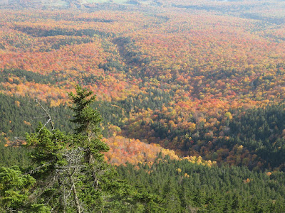
Timed it just right for peak foliage in the vast hardwood forest on the floor of The Bowl. Rounded Mt. Wonalancet is on the L, and spurs of Mt. Whiteface on the R.

Looking down and across the slab.

Color explosion.

Back on the Rollins Trail, heading south.

On the Rollins Trail, climbing the first hump along the ridge.

An open ledge at the top of this hump offers a dramatic view down into The Bowl and out to distant horizons.

Looking up the ridge to the knobby south summit of Mt. Whiteface.

Mt. Chocorua behind Mt. Paugus.

A 250-foot relocation cut in 2020 by WODC volunteers with direction from USFS bypasses what was a tricky ledge traverse at the edge of a dropoff.

Nice jointing on this mossy ledge.

Another outlook farther along the Rollins Trail, where you stand and look over the scrub to Mt. Passaconaway and the eastern Sandwich Range.

The headwall slab I visited earlier in the day.

Nice ridge walking.

The wooded, nondescript true summit of Mt. Whiteface is marked by a cairn.

A bulging ledge on the open south summit of Whiteface.

Long and wide view over the Lakes Region.

Time for the steep descent on Blueberry Ledge Trail, The upper part was cut by Thomas Wiggin in 1895, and the lower part by the WODC in 1899. It is still maintained by WODC.

Less than 0.1 mile below the south summit is one of the great view ledges in the White Mountains.

To the north it peers through the Whiteface-Passaconaway col to Mt. Washington, Carter Dome and other distant peaks.

The viewing treasure here is the vista across The Bowl to Mt. Passaconaway and the Wonalancet Range.

The headwall of The Bowl at its peak. This ledge is a hard place to leave, on a golden warm October day.

Not far below, after one of several down-scrambles, a ledge on the other (west) side of the trail looks across the "white face" cliff to Sandwich Dome with Flat Mountain Pond snaking along its base.

Down we go!

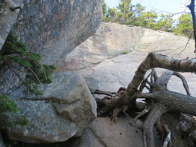
One of the tricky ledges the trail descends.

Peering down at the notorious ledge with the holes remaining from steps that were once bolted to the rock.

A dramatic angle looking across the steepest part of the ledge.

Looking back up at that scramble.
Another great view ledge awaits just below, gazing SW.

The sharp cut of the ravine of White Brook stood out in the late afternoon light. The great south cliff of Whiteface was bared by a massive landslide in 1820, Visiting the site two decades later, state geologist Charles T. Jackson noted that the heavy rains caused the slide to burst through a temporary dam, “sweeping in its impetuous course rocks and trees in promiscuous confusion, and cutting a deep ravine in the side of the mountain several miles in extent.”
There are several impressive rock staircases on Blueberry Ledge Trail as it descends steeply off the upper ridge. These were built by the OBP Trailworks crew from 2009-2011.

The top of the gentle Blueberry Ledges, from which the trail takes its name, at 2150 ft.

Trail junction on the ledges, two miles out from here to complete the 10 1/2 mile loop.


Incredible fall colors!
ReplyDelete