
An
interesting bushwhack and trail loop from the Smarts Brook Trail.
Bushwhacked up to an open rock patch on an old slide, and then on to the
Algonquin Trail on Black Mountain, the 3500-ft. SW spur of Sandwich
Dome. Descended 1.5 miles on Algonquin Trail, enjoying many fine views,
then whacked back down to Smarts Brook Trail.
The
day's primary objective was this old slide scar near the head of a
brook on the flank of Black Mountain. That scar had been staring at me
for the last several years as I looked across the Smarts Brook valley
from viewpoints on Acteon Ridge.


Rock walls in the Smarts Brook Gorge, along the Pine Flats Trail.

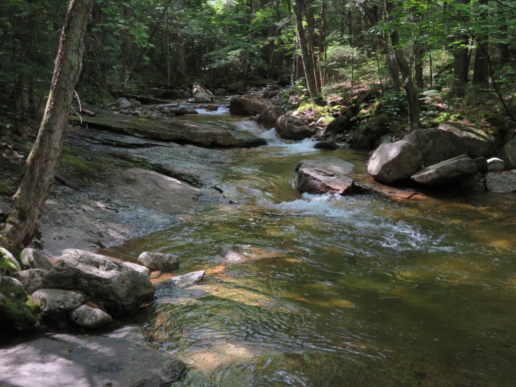
Waterslide on Smarts Brook, along the Yellow Jacket Trail.
Sled runner from an old logging camp site near the Smarts Brook beaver pond. For an interesting tale about logging in the Smarts Brook valley in the 1920s, see "Snow Medicine," by Sherman Adams (a gifted storyteller) in the December 1962 issue of Appalachia.

The east half of the Smarts Brook beaver pond has dried up. The west half (harder to see from the trail) has recently been dammed by beavers.

Along the Smarts Brook Trail.


I launched the bushwhack shortly after crossing this tributary brook.

My route followed a long spur ridge up from the valley.

The lower part of the ridge, which I had scouted on a November trip a couple of years ago, is cloaked in open hardwoods, including this elbow tree.

The lushness of summer.

Some interesting boulders are scattered through the forest.

Nice glade.

A giant old yellow birch.

At the top of the hardwoods a belt of young conifers awaited.

But the thick going didn't last long, and from here on up the ridge featured mostly open spruce forest.

Could it really be this open?

We'll take it!

Going up...

A small plateau.

Dipped down here to make a sidehill traverse to the slide scar.

The hardest section was this steep sidehill area, but even here the woods were kind.

Mt. Osceola came into view at the edge of the slide scar.

Most of this old slide (date uncertain) has been revegetated with a variety of shrubs and small trees, including sheep laurel, red spruce, birch, and alder.

Some steep rock slabs remain exposed.

The slide scar offers fine views to the west...
...and to the NW...
...including a great look at the cliffs of Sachem Peak.

Mt. Moosilauke looms darkly behind Welch & Dickey and Middle Acteon Peak.

Looking down the old slide swath.

Parting shot after a long sojourn.

I continued upward, following the small brook that runs down the old slide track.

The terrain is steep above the slide.

Looking down what looked like the old track, above the open patch.

Headwater of the brook.

A stiff workout, but the woods remained mostly open.

The terrain leveled off in fern glades as I approached the col on the north side of Black Mountain.

Nice!

I reached the Algonquin Trail and followed it over the summit of Black Mountain.

A peek back at the summit of Sandwich Dome.

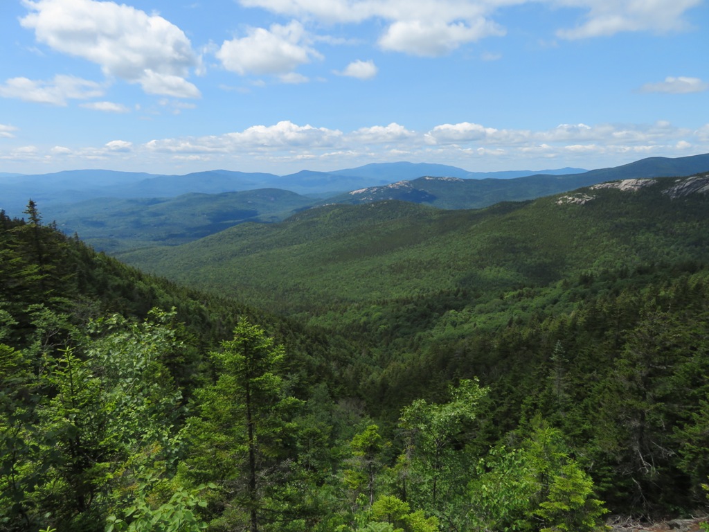
On the south side of the peak, the wide western viewpoint beckoned for a break. This big mountain vista included several distant peaks in the Green Mountains.

The southerly view included Sunapee Mountain, Mt. Kearsarge and the dim bulk of Mt. Monadnock.

"Boat Rock"

A bit farther along the ridge is this magnificent perch overlooking the hill, pond and lake country to the south.

Mt. Israel and the Ossipee Mountains are seen beyond Black Mountain Pond.

A true bird's eye view of this backcountry beauty.

An expansive view of the Sandwich Notch area with the Squam Range beyond. Kiah Pond and Lower Hall Pond can be spotted out there.

Looking towards the Campton Range.

Looking NE to Black Mountain and a high shoulder of Sandwich Dome.

On top of the world.

Weathered signs where two rugged trails meet on the ridgecrest.

The Algonquin Trail descends in the open for a stretch, with the smaller Black Mountain below.

Steep and rough.

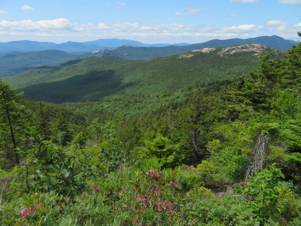
Farther down a short side path leads to more great views, here looking north to Mt. Tecumseh, the Osceolas above Sachem Peak, and Jennings Peak.

Mt. Hancock seen through Mad River Notch.

A wide vista over the Smarts Brook valley.


More views.

The top of the lowest and trickiest scramble, which earned Algonquin Trail a spot as an "elective" on the Terrifying 25 List.

The scramble from below.

Ferny col between the two Black Mountains.

After descending below the smaller Black Mountain, I left the trail and whacked across a plateau of open spruces.

Pretty fern glade.

I descended through a familiar hardwood basin.

Leaners.

A favorite cascade on a tributary of Smarts Brook.

Evening at the Smarts Brook beaver pond.

Smarts Brook Cascade.


No comments:
Post a Comment