
This mountain in Orford, NH rises to only 2,909 ft., but due its isolated location and open ledges, it offers some of the best views in the White Mountain region from its South Peak and North Peak. And the outlooks from the two summits are completely different.
Recently, climbing Cube in the spring has become an annual highlight for me. Over the last three years I've used each of the three routes up the mountain - the scenic Kodak Trail from the south in 2010, the Mount Cube Trail from the north last year (these are both links in the Appalachian Trail), and for the hike described here, the Mount Cube Section of the Cross-Rivendell Trail from the west. At 2.1 mi. this is the shortest route to the summit, and it passes two viewpoints en route.
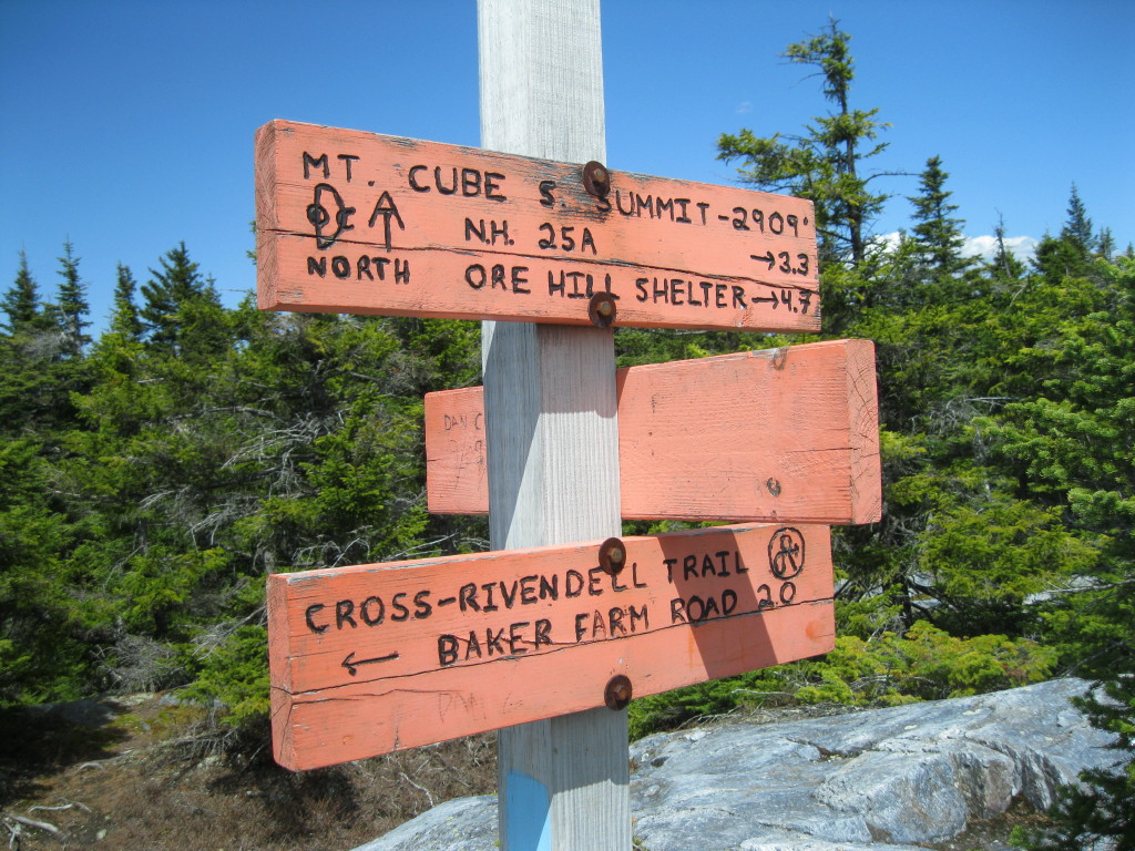
A blue Cross-Rivendell Trail sign marks the trailhead on gravel Baker Rd., off Rt. 25A. The summit of Cube is the eastern terminus of the CRT, which extends 36 mi. to Flagpole Hill in Vershire, VT. For more on this interesting trail, click here.

The Mount Cube Section has moderate grades with many switchbacks, and good footing in the lower half.

In the hardwoods I found this nice pair of trout lilies.

Above the hardwoods there's a traverse through a beautiful spruce grove.

The footing gets rockier, and the trail makes a hairpin turn L and climbs to a cleared outlook to the west. Sunday Mountain, which is traversed by the Cross-Rivendell Trail, is the rounded summit to the R of center. Mts. Abraham and Ellen in the Green Mountains can be seen above it on the horizon.

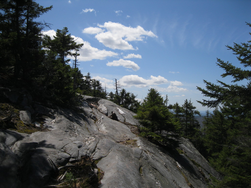
Rocky switchbacks lead up to a quartzite ledge with more westerly views. The quartzite on Cube is an extremely hard and polished metamorphic rock that is slippery when wet.
Looking SW, a view of Mason Pond, enclosed by the low summits of Mousley, Moody, Stonehouse and Bundy Mountains.

The trail descends gradually to a pretty area called Birch Meadow in the Cross-Rivendell Trail guidebook. (There may be copies of the guidebook available via mail order; check on the CRT website. The waterproof map of the trail can also be purchased there, and we do sell it at the Mountain Wanderer.)

Indian Poke was sprouting here.

There were near-carpets of trout lilies in a couple of spots.

The last pitch to the South Peak scales steep quartzite ledges.

At the summit is an old survey marker, left by the U.S. Coastal Survey in the 1870s. Under the supervision of Dartmouth professor E.T. Quimby, the summit of Cube was occupied as a survey station because of its long views over the surrounding area. On more erodible granite ledges atop other peaks (such as the south summit of Mt. Whiteface), these etched triangles are sometimes barely discernible. The mark is well-preserved in the tough quartzite of Mt. Cube.

Dartmouth Outing Club signs at the summit.
My favorite vista from Cube is southward towards the great, tower-topped bulk of Smarts Mountain with its sweeping ridgelines.

To the SE are Mt. Cardigan (center) and distant Mt. Kearsarge (way back on the R).


A visit to the North Peak is a must on a good viewing day. From a junction just north of the South Peak, the North Cube Side Trail, rough and overgrown in places, leads 0.3 mi. to open ledges facing NE.

The view here is superb, looking over Upper Baker Pond to Mt. Moosilauke. The Benton Range and Mt. Clough sprawl to the L of the Moose.

A closer look at Moosilauke. The Kinsmans poke up between Moosilauke and Clough.

Looking NE to the more distant peaks of the Whites: (L to R) the Hancocks and Carrigain, Osceola, and the Sandwich Range, seen beyond Mt. Cushman and Mt. Kineo.

To the east the great ridge of Carr Mountain sprawls for miles from stem to stern.

I enjoyed a relaxing stay here, as well as two sojourns on the South Peak. This was a day to savor the views!
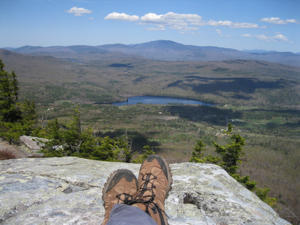
A last look at Smarts Mountain, with Holts Ledge and Moose Mountain on the far R, before heading down. On a day when the Mount Washington Observatory reported 100-mile visibility, there are few
better places to visit than Mount Cube. For much more information on Mount Cube, click here.


Thanks for a great report about one of my favorite NH hills. My wife and I have climbed from all three approaches this spring, and each time we do, we say "this is our favorite!" We also talk every trip about how cool it must be for through-hikers, seeing the different emerging views of Moosilauke and the Whites as they go over Moose, Smart's, Cube, Webster Slide, ans finally the last 100' or so to Moosilauke when, bam!, the whole White Mountain panorama opens up! thanks again, and keep up the good work!
ReplyDeleteThanks, Scubahhh! You're right, each of the three Cube approaches has much to recommend it. That's a neat perspective you give on the thru-hiker's experience in this section. Never thought of it that way.
ReplyDeleteSteve
I wondered where you would go yesterday ;o)
ReplyDeleteWhat a beauty to be out (UP) there!
LCA Prop. Mgr
It was a perfect spring day!
ReplyDeleteSteve
As your photos beautifully show, Monday (07-May) was a terrific Spring Day! Some spring-green color is evident in your snapshots, but it appears that "spring had not fully sprung", even in that more southerly region. However, it should be a completely different story on the next good hiking day. With the rain we've received today (08-May), I can almost sit and watch the leaves pop out!!
ReplyDeleteJohn
Steve,
ReplyDeleteI agree, Mount Cube is a wonderful mountain, and like you I have done it by all three trails, each enjoyable in its own way. My favorite is up CRT and down Kodak Trail, great views on both trails but a long road walk if you only have one car.
A BIT OF MT CUBE HISTORY: My grandparents owned a dairy farm at the base of Mt Cube, Rt 25 A. Their pastures were on both sides of the highway. Long before it was a hiking area. I spent several summers haying with a team of horses in fields on the side of the mountain. Not an easy job to keep the horses steady on an inclined hill with a wooden wagon. My greatgrandmother lived next door until the age of 98. Indian arrowheads were found in the walls of her house after her death.
ReplyDeleteHi Bruce, Thanks for sharing those great memories. That is a beautiful pastoral area and obviously has some interesting history.
DeleteSteve
Does anyone know what the inscription says at the top of Cube?
ReplyDelete