
My good friend Cath Goodwin was planning to do some trail redlining in the Speckled Mountain area on the south side of Evans Notch. She invited me to tag along, the plan being that I would hike the Bickford Slides Loop with her, then, while she continued on to Spruce Hill Trail and points beyond, I would embark on a favorite bushwhack to ledges on Sugarloaf Mountain (1451 ft.), a low southwestern spur of Speckled.
It was a gorgeous sunny spring day with endless blue skies, temps rising to the upper 40s, and a stiff NW breeze. We parked by the road to Basin Pond; just north of here, Rt. 113 through Evans Notch is gated until later in the spring. Accompanied by Cath's dog Smokey, we walked up the road, soon crossing into Maine.
 We made a detour left into a field maintained as a wildlife opening by the Forest Service. Here we had a view up to a cliff at the south end of Sugarloaf Mountain, which I believe was once called Brickett Crag. The ledgy shoulder rising behind on the L was once known as Long Mountain, but is nameless on current maps.
 Rt. 113 soon crossed a bridge with a view of the peaceful Cold River.
 Just beyond was another wildlife field, with an impressive view of the ledgy mass of West Royce.
 We turned off the road at the historic Brickett Place, with its namesake crag rising above. There wasn't much bird activity on this windy day, but a phoebe was singing here.
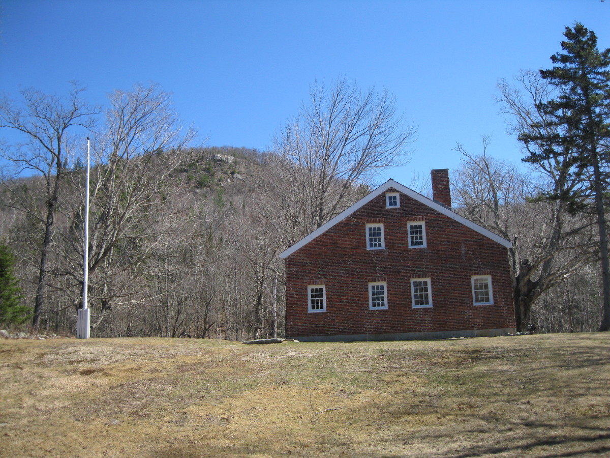 This house was built by homesteader John Brickett in 1812. He fired his own bricks on-site.
 It's listed on the National Register of Historic Places, though the date seems to be off on the plaque. The building has undergone a major renovation in the last couple of years. A little-known fact is that from 1948-1956, this was operated as a hut by the AMC under a special use permit from the Forest Service. Evans Notch Hut, as it was called, was the easternmost in the chain.
 The Bickford Brook Trail, which mostly follows an old service road used for the former firetower on Speckled Mountain, starts near the old garage at Brickett Place.
 After climbing for 0.3 mi., the trail turns R onto the well-graded old road, passing by some large oaks.
 Smokey enjoys the great spring walking.
The trail soon enters the Caribou-Speckled Mountain Wilderness, a small (12,000 acres) but extremely interesting area.
 To reach the Bickford Slides Loop, we turned R onto the Blueberry Ledge Trail. Here Smokey makes friends with a snacking blogger.
 Down at Bickford Brook, we followed an old road a short distance R for a screened view of the main waterfall of Lower Bickford Slide.
 Above that waterfall, just downstream from where the Blueberry Ridge Trail crosses the brook, is this interesting sluice in the streambed.
 Here the Bickford Slides Loop diverges L and also crosses the brook. The crossing was easy today.
 The first part of the Loop is gentle as it follows a quiet section of the brook.
 The trail makes several crossings of a loop of the brook, where it takes some care to follow.
 It climbs steeply, then drops to a point above a picturesque pool at the base of the Middle Slide. Unfortunately the steep side path to the pool has been partly eroded away, so we didn't try to get down to the edge.
 A veiled view of the Middle Slide. The brook scenery on this trail is best when the leaves are down.
 The trail is narrow and rough as it runs along the rim of the gorge.
 Smaller cascades are seen along the way. What a scenic route!
 There are several flume-like formations.
 The Upper Slide, seen through the trees.
The Loop crosses the brook above the Upper Slide and climbs a short way to the Bickford Brook Trail, 0.4 mi. above the Blueberry Ridge Trail junction. Here Cath and Smokey continued up the Bickford Brook Trail, while I set off on my short bushwhack to Sugarloaf Mountain.
 After a late lunch, I headed up and across the slope through sunny hardwoods.
 My next stop was a massive ledge on the east flank of Sugarloaf, one of my all-time favorite spring objectives. To the NE it provides a view up the Bickford Brook valley to Blueberry Ridge. The scenic Blueberry Ridge Trail skirts the ledge patch seen just R of center. The top of Speckled Mountain just peers over in back on the L.
 The ledge also has an extensive view SSW down the Cold River valley. Peaks visible here include (L to R) Shaw, Kearsarge North over Slope, Eastman and South Baldface.
Close by to the SE is flat-topped Blueberry Mountain.
 Due south are the Deer Hills, with Big Deer on the L and Little Deer on the R. The bumpy ridge above Little Deer is Major Mountain (no relation to the Major in the Belknap Range), with Black Cap peeking over on its R.
 In the sun and out of the wind - time for a spring siesta.
From here, a short climb brought me to another ledge on the south summit of Sugarloaf. I chose my steps carefully to avoid trampling lichens on and around the ledges. It doesn't take much extra effort for bushwhackers to do this. Here there was a nice spread of the Baldface Range, with Mt. Meader on the R.
 Through a gap in the trees I could see South, Middle and North Carter over the Basin Rim.
 Looking north, there was a peek at some cliffs on Long Mountain. I paid them a visit the last time I was in this area two years ago.
 I then continued south along the crest of Sugarloaf. At one point it looked like there was a trace of an old trail. From 1936-1947 the WMNF Brickett Trail ran across Sugarloaf, though its exact route is uncertain. The AMC guidebook description mentioned that it passed three vistas.
 I came upon a single large cairn.
 At the south end of the ridge I descended through scrubby oaks, skirting lichen patches, to Brickett Crag. I've seen that name somewhere, but can't recall the source. This is a dramatic perch, with Brickett Place visible through the trees below.
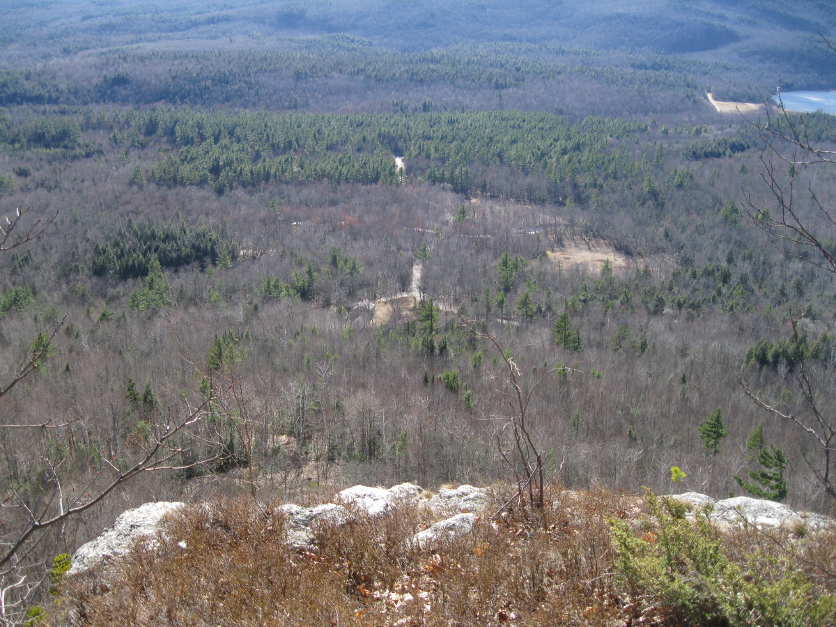 Wide-open view down the Cold River valley.
 The sweep of the Baldface Range.
 There's also a neat view west into the low glacial cirque known as The Basin, with Basin Pond (created by a dam) on its floor and Mt. Meader looming above.
 Some nice oak forest up on this ridge.
 A stiff descent through hardwoods - with slippery leaves contributing to one sliding fall - brought me back down to the Bickford Brook Trail.
From Brickett Place I looked back up at the crag where I had recently been sitting. Back at the car I rendezvoused with Cath. While I had been on my dawdling bushwhack, she had climbed Bickford Brook Trail to Spruce Hill Trail, descended that to Rt. 113, crossed the road and zipped up East Royce, then descended the Royce Trail past Mad River Falls back to Brickett Place, fashioning a 10 1/2 mi. loop. All in all, it was a fine spring day on the south side of Evans Notch..


Steve, what a superb Springtime adventure you and Cath had in Evans Notch! I realize that you eventually went your separate ways, but I'm certain you both had a great day on your tailor-made treks.
ReplyDeleteYou used the word "dawdling" to describe your bushwhack. I've never known you to "dawdle". I feel that perhaps a better descriptor for your portion of the Evans Notch adventure might be something such as "methodical" or "measured"! :)
John
Thanks, John! There's some great scenery in that area. The last time I did Bickford Slides Loop, Carol and I were caught in a thunderstorm at the Middle Slide pool and hightailed it out. It was nice to have more time to appreciate all the brook scenery. And for a whack, Sugarloaf has a very high reward-to-effort ratio.
ReplyDeleteSteve
Steve, that was a very enjoyable report! Brickett Crag looks like a superb perch. The Bickford slides have always been a favorite of mine, especially in the late spring with the green moss and wildflowers. Now I can look forward to adding an excellent bushwhack to my next waterfall visit!
ReplyDeleteThanks, Chris. That whole area is wonderful in the spring.
ReplyDeleteSteve