
MONROE-FRANKLIN TRAVERSE: 8/12/11
All of the weather forecasts promised partly sunny skies and summits in the clear after early morning fog. Seemed like a good day to get up on the Southern Presidentials. The Presys were smothered in cloud as I drove up the Cog Road, but I had faith in the forecast. There were lots of folks who had the same idea and were heading up the Ammonoosuc Ravine Trail.
 The first mile leads through some nice open fir-birch forest.
 This sign is located where the spur trail (the older route) comes in from the Cog Base Station.
 The trail follows the attractive Ammonoosuc River.

The memorial for a Dartmouth Outing Club student who died of hypothermia along this trail in 1928.

One incentive for this hike was a chance to see the aftermath of a major avalanche that thundered down Ammonoosuc Ravine in February, 2010.Shortly after crossing Monroe Brook, I saw the first avalanche debris in the riverbed.
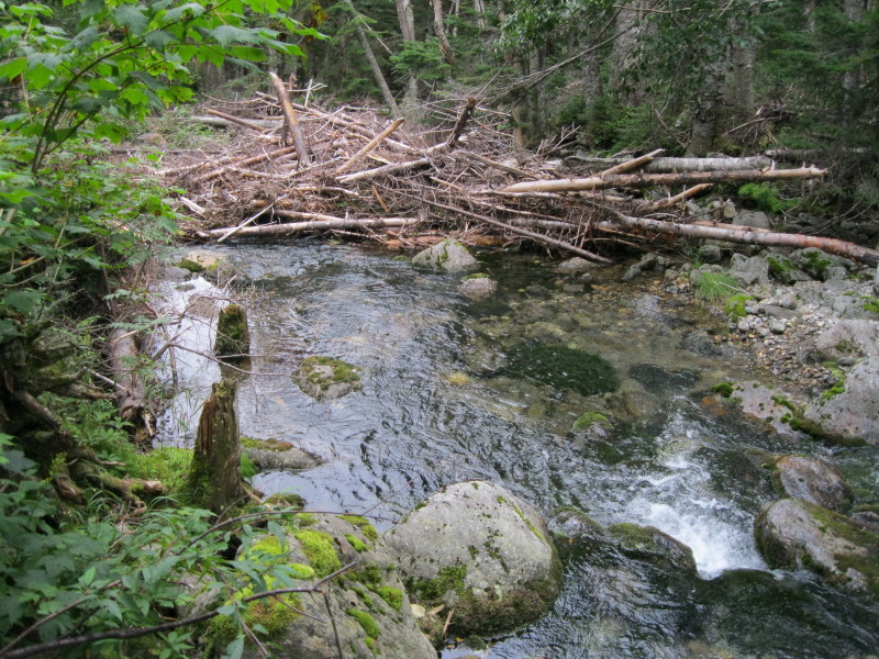
The avalanche grazed the trail in one stretch, opening up some new views, though the ravine headwall was hidden in the clouds .
 Asters were blooming in profusion in this newly opened spot.
 By bushwhacking a few yards to the L, I got a good look at the wide swath of destruction.
 This would be a neat view on a clear day.
 A short distance past the avalanche track, I came to the lovely Gem Pool.
 Here's where the steep climbing begins - almost 1600 ft. of elevation in a mile. The lower part is mostly one long rock staircase - impressive trail construction!

There was a logjam of large hiking groups at the side path to "The Gorge," but it was worth the short wait to go down there. A spectacular sight, even with fairly low water flow.
 The fog started at about 4000 ft., and here's where the trail starts to get ledgy and, in places, slippery. A short ladder helps on one steep ledge.
 A cascade along the trail. The "Ammy," as hut folks fondly refer to it, is surely one of the most scenic routes in the Presys.
 Two hikers climb through the fog alongside another cascade.
 This one was pretty even with very little water flow.
 It rained lightly for about 20 minutes, making for slick footing on the ledges.

The trail breaks above treeline shortly before reaching Lakes of the Clouds Hut.
 Classic trail sign.
 There was no one outside at the hut, but inside the place was hopping with both overnight guests and day hikers hanging out and waiting to see if the fog would clear. After taking a long lunch break inside, I headed a short distance along the Dry River Trail, where I had this view back to the fogbound hut.
 The trail drops down to the rocky shore of the Lower Lake of the Clouds, which was living up to its billing today.
 In the fog, the Southern Presidential landscape is reminiscent of the Scottish Highlands.The Lower Lake reminded me of a small lochan I visited many years ago in Scotland, high in the valley known as Glen Nevis, on a rainy day when I saw only one other hillwalker.
 Since I was up here, I figured I might as well follow through with my plan to climb Mt. Monroe and head south on the Crawford Path towards Mt. Franklin.
 Approaching the summit.
 Summit crags. The mist was so thick you couldn't even see down to the Crawford Path on the Monroe Flats.
 A neat cairn on the way to Little Monroe.
 Steep drop off Little Monroe.
 A hiker looms in the mist. I could hear the clicking of trekking poles on the rocks before passing hikers became visible.
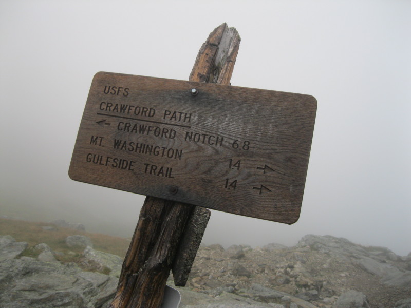
 The junction with the northern and much more used unofficial side path to the 5001-ft. summit of Mt. Franklin.
 A cairn marks the summit, which on a clear day has a unique view down into Oakes Gulf. The southern side path that leads back to the Crawford Path is not nearly as obvious as the northern path, and has some potential for hikers to wander off into the alpine vegetation. If you're Franklin-bound, better to go up and back on the northern path.
 I love the stretch of Crawford Path on the broad southern shoulder of Franklin, where the tundra seems to stretch on forever.
 As I descended towards the Franklin-Eisenhower col, there was a gap in the clouds, revealing Cherry Mtn. and distant peaks to the west.
 Some iron pins in a ledge, presumably left over from the days when this was a bridle path and the horses needed a little help getting up this pitch..
 I dropped down below the clouds, and suddenly the views opened dramatically, here looking out at Bretton Woods.
 At about 4600 ft. I parked myself on a great ledge perch on the left edge of the trail, where there was a terrific view down the huge Dry River valley to the Sandwich Range on the horizon.
 Passaconaway, Whiteface, the Sleepers, the Tripyramids and Sandwich Dome could all be seen.
 Looking eastward across the valley to Monatalban Ridge and distant ridges beyond.
 A closer look at Mt. Isolation (L) and Mt. Davis (R).
 Looking down the ridge to Mt. Eisenhower. I was originally planning to go up Ike, but there were still clouds tickling the summit, and after sitting on this trailside ledge for a while I concluded that it was probably a better viewpoint anyway.
 Looking at Carrigain, the Hancocks, Willey, and a ridge dropping off Eisenhower towards Dry River. These views were a sweet reward after spending most of the day in the clouds.
 Looking back up at the ledge, which I now consider one of the finest spots along the Crawford Path.
 View north to the Pliny Range.
 I made a short side trip down the Mt. Eisenhower Trail to check out views from the short open section near the top.
 I liked this view down the remote side valley under Eisenhower that feeds into the main Dry River valley.
 Before descending the Edmands Path, I made a short side trip on the Eisenhower Loop for a look at Red Pond, now more bog than pond.
 As I started down, the clouds had cleared off the shoulder of Franklin.
 J. Rayner Edmands, the great trail-builder known for his well-graded paths, had this trail rebuilt in 1909. Rocks were laid flat to create a good footway across this sidehill talus slope.
 The stone gateway at 4000 ft.
 A typical section of the Edmands Path. Though erosion has taken a toll over the years, it still has the best footing of just about any route off the Presidentials. Most of the way down I hiked with a nice couple who were camping down in the hardwoods and trekking up to the ridge each day. I concluded my hike with a 2.3 mi. road walk back to the Ammonoosuc Ravine parking lot. I won't repeat that anytime soon, as the unrelenting uphill mile on the Cog Road was not much fun at the end of the day! But it was a great traverse across one of the finest ridge sections in the Whites.


Terrific report, as always! In some ways, it's too bad about the fog not lifting as predicted, but in other ways, I think it's sort of nice to experience these conditions every now and then!
ReplyDeleteFor some reason (failing memory, most likely!) it slipped my mind that you had hiked in the Scottish Highlands. Regardless, you are so right, the landscape with the accompanying fog is very reminiscent of hiking in that part of the world! I've hiked some mountains located a bit south of the Scottish border (Windermere area of England), and experienced conditions in a landscape somewhat similar to what you must have experienced in Scotland (and more recently in the Southern Presidential Range!!).
John
Thanks, John! These conditions certainly reminded me of the Highlands, and also of a climb of Helvellyn in the Lake District in pouring rain (along the Swirral Edge rather than the famous Striding Edge). Never got so wet in my life as I did in the U.K.
ReplyDeleteIt's always more dramatic when views appear after they've been denied for a while by the fog. So I got to experience both on this particular hike.
Steve