
WEBSTER-JACKSON TRAVERSE: 8/17/11
A perfect summer day: temp around 70, low humidity, sunny skies, endless views. The Webster Cliff Trail, one of the classic routes in the Whites, was calling.

A little way in from the trailhead on US 302 in Crawford Notch, the trail comes to this plaque honoring two of the founders and longtime leaders of the AMC Four Thousand Footer Club.

The Robertson Bridge over the Saco River.
 A stillwater stretch of the Saco.
 The lower part of the Webster Cliff Trail leads through a fine hardwood forest.
 At 1.4 mi. the trail crosses a small landslide that fell in 2009.
 Trail workers have stabilized the crossing with rock steps.
 Just above the slide there's a tricky ledge scramble. This spot is really nasty when it's icy.
 It was a good stiff climb - 1,750 ft. of elevation in 1.8 mi. - to the first of the Webster Cliff's many outlook ledges.
 On a day like this, it's worth every huff and puff when you stare down to the floor of Crawford Notch.
 The great wall of Mt. Willey towers above the Notch. What an ominous mountain!
 Bondcliff, Mt. Bond and Mt. Guyot rise beyond the plateau south of Mt. Willey.
 Webster Cliff is an entertaining trail, ducking back into conifer corridors in between the viewpoints.
 Looking up the ridge towards the summit.
 At 2.4 mi. you cross this big open ledge with a large cairn.
 This spot offers a glimpse north to Boott Spur and Mt. Washington.
 Whilke relaxing here, I heard the toot of the Conway Scenic Railroad train climbing up through the Notch, and caught a look as it passed below the slab that ice climbers call the Willey Slide (not to be confused with the famous Willey Slide that fell in 1826 and is now fully revegetated.)
 Beyond a col, the trail climbs to another great outlook. This is the view south.
 This is the best spot along the Webster Cliffs for a clear look at Montalban Ridge. Here you can see (L to R) Stairs Mtn., Mt. Resolution, Mt. Crawford and Mt. Hope.
 The Webster Cliff Trail surprises with an occasional very steep scramble. Overall, it's a more strenuous and tiring trail than the stats would seem to indicate.
 A boulder perched on yet another great vantage point.
 A vista into the eastern Pemi Wilderness.
 Looking back down another steep pitch.
 It's fun to look back down the ridge with ever-changing perspectives.
 A down-look at Willey Pond and the Willey House Site.
 Yet another ledge scramble.
 The ridge now stretches far off to the south. Chocorua is at the center of the horizon.
 I watched the train again on its way back down the Notch, as it crossed the Willey Brook Trestle.
 One last scramble before the summit of Mt. Webster.
 Open ledges at the 3910-ft. summit offer a fine view north to the higher Presidential peaks.
 Mt. Washington rises impressively behind the rocky little cone of Mt. Jackson.
 Looking NW to the Dartmouth Range and Cherry Mtn.
 The Gray Jay is a frequent companion during a summit stay in the Crawford Notch area.

The day was so fine, I decided to continue across to Mt. Jackson, then descend the Webster-Jackson Trail and take my chances hitchhiking back to my car. The Webster Cliff Trail cuts through conifer woods across the ridge, with several ups and downs.
 The cone of Mt. Jackson is a steep scramble no matter which side you approach it from.
 Near the top, a great view back to the SW.
 Looking back at Mt. Webster, with Carrigain, Hancock and Willey beyond.
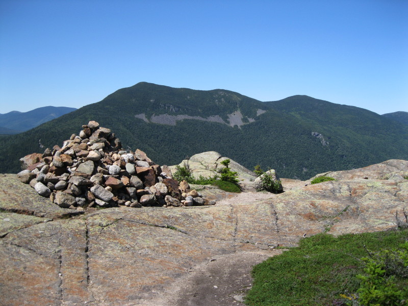
 Big cairn at the summit.

Looking up the range to Pierce, Eisenhower, Monroe and Washington.
 The great expanse of the Dry River valley spreads below Washington and Boott Spur. Closer in is the spur valley followed by the Mt. Clinton Trail.
 It doesn't get much clearer than this in the summer.
 Looking across the Dry River valley at Mt. Isolation.
 Looking west. Because I arrived here late in the afternoon, I had the summit to myself for an hour.
 The top of the steep, ledgy descent off Jackson on the Webster-Jackson Trail.
 This is a rugged stretch of trail.
 Looking back up at the summit from a fir wave. From here the trail is less steep, but the footing is consistently rough and wet. For me, it's a pretty slow 2.6 mi. to descend.
 At the Webster-Jackson trail fork, I made a short, steep descent on the Webster Branch to see this lovely waterfall on Silver Cascade Brook.
 Farther down I made the short side trip out to Bugle Cliff, where the sun had already set on Saco Lake and the Highland Center. As this photo shows, it was a late exit, and I had no luck hitching a ride during the half-hour of daylight I had left. So I ended up walking down Rt. 302 through the Notch in the dark, clambering over the guardrail when vehicles came by. At least it was all downhill.
 At the Willey House site I left the road, opting to hike the Sam Willey Trail and Saco River Trail by headlamp back to the lower end of the Webster Cliff Trail. I took a break at the Willey Pond dam, where I could see stars in profusion when my headlamp was off. The Big Dipper hung high over Mt. Willard.
The walk along the trails was very pleasant by headlamp, especially compared to the road walk. It was spiced up when some coyotes yipped and howled. Thankfully they were behind me, not in the direction I was going. A 10 pm exit is late even for me, a notorious late finisher, but it certainly was a long and rewarding day in the mountains.


Steve, you surely had a terrific day in the Whites! I can certainly understand why you opted to go for a route that was perhaps longer than originally planned. As you indicated in your report, that particular day was a rare Summer day in the Whites for splendid views! As you know, I was doing a hike to Mt. Garfield on that day, and was privileged to experience those remarkable conditions as well.
ReplyDeleteExcellent report, as always!
John
Thanks, John - that was certainly one of the finest days of the summer!
ReplyDeleteSteve
Hi Steve
ReplyDeleteNoticed your reference on the coyotes! I usually hike solo and am always a bit concerned with meeting wildlife, especially on what I consider more in the woods hikes, e.g. the Table to Attitash traverse. Have you ever had a problem? (Do you carry anything like pepper spray?)
On a funny note: actually got chased down that trail by a Spruce Grouse!
Really enjoy your trip reports
Best
Charlie S.
Merrimac, MA
Hi Charlie,
ReplyDeleteThanks for your comment! Coyotes are not normally considered a threat to hikers, but when you're alone in the dark and they're howling nearby, you wonder...I once saw a pack of five across a pond in winter, in daytime, and was a little nervous. I don't carry pepper spray. The most threatened I felt was when a bull moose apparently objected to my presence on the Blueberry Ledge Trail during rutting season. I hightailed it down through the woods to get around him.
Mother grouse can be among the most aggressive creatures in the woods!
Steve
great blog! Can't believe your end of day route to get back to your car, good for you and sounds like you had a good attitude about it. we hiked Jackson yesterday (5/29/18) and had great weather. the waterfall was one of the highlights and I even went for a swim on our way down
ReplyDeleteThanks, Jeff. It was a long walk back! Glad you had a good day on Jackson.
Delete