
I had only done this lightly-used NW route up Smarts Mountain once before, and wanted to check its condition. Formerly named the Mousley Brook Trail and once part of the Appalachian Trail, it was renamed in 1993 in honor of Daniel Doan, author of 50 Hikes in the White Mountains, 50 More Hikes in New Hampshire, and several other books. Over the last several years, volunteers from Trailwrights and the Dartmouth Outing Club and members of the Doan family (including Dan's daughter, Ruth Doan MacDougall, who now edits his 50 Hikes books) have been working to address wetness and erosion issues on the trail, as well as brushing it out.
There is a small parking area for the trail at the end of Mousley Brook Rd., a spur off of Quinttown Rd. Hikers should be aware that the trail starts out on private land, soon passing a house whose owners have horses; hikers' dogs should be leashed here. Farther up, the trail climbs through private land under conservation easement. The upper section passes through land within the Appalachian Trail corridor, though this route is no longer part of the AT.
I set off about 10:00 on a warm, sunny late October morning.

A sign points the way at a road junction a short distance from the trailhead. The Smith Mountain Trail is a snowmobile route that runs along the western base of Smarts.

On my last visit to this trailhead, I followed the Smith Mountain Trail and bushwhacked to the 2,213-ft. summit of my namesake mountain, where there is a little grassy clearing but no view.

Volunteers have done some good ditching work on the lower part of the Daniel Doan Trail, which follows an old road with chronic wetness problems.

It had rained heavily the day before, on top of several previous deluges in recent weeks, so there was a lot of wet footing.
 In one section there was a stream running down the trail.
Farther up the footing improved and the trail ran alongside pretty Mousley Brook.

There is a fine hardwood forest in this part of the valley.
 At 1.9 mi. the trail crosses Mousley Brook. Despite all the rain, this was not a difficult crossing.
 Several cascades can be glimpsed from the trail along the next section. I made short bushwhacks to get closer looks at these.


A beautiful walk up the valley through here.

A newer light blue blaze (indicating a side trail feeding into the AT) and an older DOC triple blaze.

The trail crosses the AT boundary at about 2600 ft. Volunteer corrdior monitors have been hard at work marking the boundary lines in rough terrain.

The upper part of the trail is steep and rough in places. Despite its relatively modest elevation of 3238 ft., Smarts is a big and rugged mountain.
 Entering the boreal forest - about as far south as this is found in New Hampshire.
 On the upper ridge, a stream runs down the trail for a short distance.
A flat and wet area up on the ridge.
 This is one of several springs in this area. They were all flowing freely this day.
 The old firewarden's cabin is now used by backpackers and is maintained by DOC.
 The trail skirts around the side of the cabin.
 The original Smarts firetower was originally built about 1915. The present steel structure was erected in 1939. It was last actively used for fire detection in 1973. The firetower was refurbished by the DOC and USFS in 1994, and is still maintained as a viewing perch for hikers.


The trapdoor that provides access to the cab is very heavy - hikers should use caution when closing it as it could cause a serious headache. The cab has windows on all sides, with an occasional missing pane.

Smarts is a phenomenal viewpoint, giving a unique perspective from western New Hampshire. On a clear day nearly the entire Green Mountain chain can be seen, from Jay Peak in the N to Stratton Mtn. in the S. I spent two hours studying the vistas, both from inside the cab and on the first landing below it. Below is a sampling of the view.
Mt. Cube is seen not far off to the N, with Piermont Mtn. behind it.
 To the NW is the little round cone of Sunday Mtn., traversed by the Cross-Rivendell Trail. Vermont's Signal Mtn. range is seen in the distance.
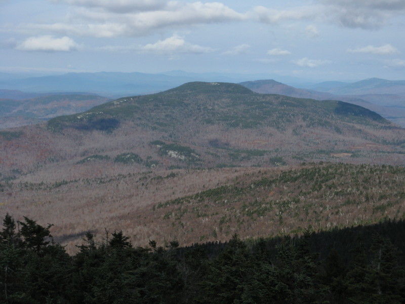
Looking NE to sprawling Carr Mtn. and the Sandwich Range.
 Mt. Clough and a cloud-capped Mt. Moosilauke.
Near the tower is a classic DOC privy.

The AT meanders through fine boreal forest along the broad crest of the mountain.
 The Smarts Mtn. Tentsite is located on the S side of the trail, to the W of the tower.
 A site with a view, looking out over Reservoir Pond with Sunapee Mtn. on the horizon.
 Before heading back, I paid an off-trail visit to a prominent brushy scar on the steep S face of the peak. I'm not sure whether this was caused by a fire, a slide or some other occurrence.
This spot provides an excellent look at my favorite vista from Smarts - down into the broad basin of Grant Brook, enclosed by Lambert Ridge on the W. (The firetower also provides a good perspective on this valley and ridge.)

Looking out towards Reservoir Pond and a few beaver ponds I visited on an exploration this spring.

A zoom on Moose Mountain, a low but interesting ridge traversed by the AT in Hanover. Mt. Ascutney looms beyond.

Coming back down the Daniel Doan Trail, caution was needed on a number of wet slabs.
 On the descent I made a foray to visit another cascade on Mousley Brook.
Beautiful birch forest on the middle part of the trail. If you're prepared for some wet and rough footing at times, you'll find the Daniel Doan Trail to be a rewarding route up this intriguing mountain. Round trip is 6.4 mi. with 1900 ft. of elevation gain.


Nice report and pictures. I was up with the Trailwrights in the spring and we did some work on this trail included the sidehill ditching.
ReplyDeleteCheers,
Cooperhill
Thanks, Chris - and kudos for your dedication in working on so many different trails.
ReplyDeleteSteve