
By a happenstance of erosion, the immense mountain mass known as Sandwich Dome rises just short of the iconic elevation of 4000 ft. But in terms of trails, views and variety of terrain it surpasses many a 4000-footer. It has long ranked high on this hiker's list of favorite mountains.
Sandwich Dome, aka Sandwich Mountain, anchors the SW end of the Sandwich Range and is almost entirely within the Sandwich Range Wilderness. From Waterville Valley its double summit and sharp Jennings Peak dominate the southern skyline.

Another impressive view of this sprawling mountain is seen looking north from Mt. Israel.

There are several interesting trail routes up Sandwich. Perhaps the most rewarding overall is the ridge-and-valley loop provided by the Sandwich Mountain Trail and Drakes Brook Trail. This trek provides views from several different elevations and angles, a leisurely ridgecrest ramble, and a descent through a secluded valley. I started the hike on a cool, partly sunny morning from the parking area off Rt. 49 near Waterville. I followed the trail through a field next to a power station and dropped steeply to cross Drakes Brook, an easy rock hop this day.

In the first 1.6 mile climb to Noon Peak, you gain 1500 ft. of elevation - more than half the total for the 8.7 mile hike. After a half-mile of moderate climbing I entered the Sandwich Range Wilderness.

Some nice hardwood shortly beyond the Wilderness boundary. Above 2300 ft. there are some attractive mossy spruce woods.
 The upper part of the ascent to Noon Peak has several short, very steep pitches. Nothing tricky, though.
The outlook ledge near Noon Peak is a great one, and makes a fine objective for a half-day hike that provides a good workout and wide views. The Tripyramids are prominent to the NE.

A neat perspective looking through Mad River Notch (between East Osceola and Mt. Kancamagus). The cliffs of West Huntington are seen beyond the notch.

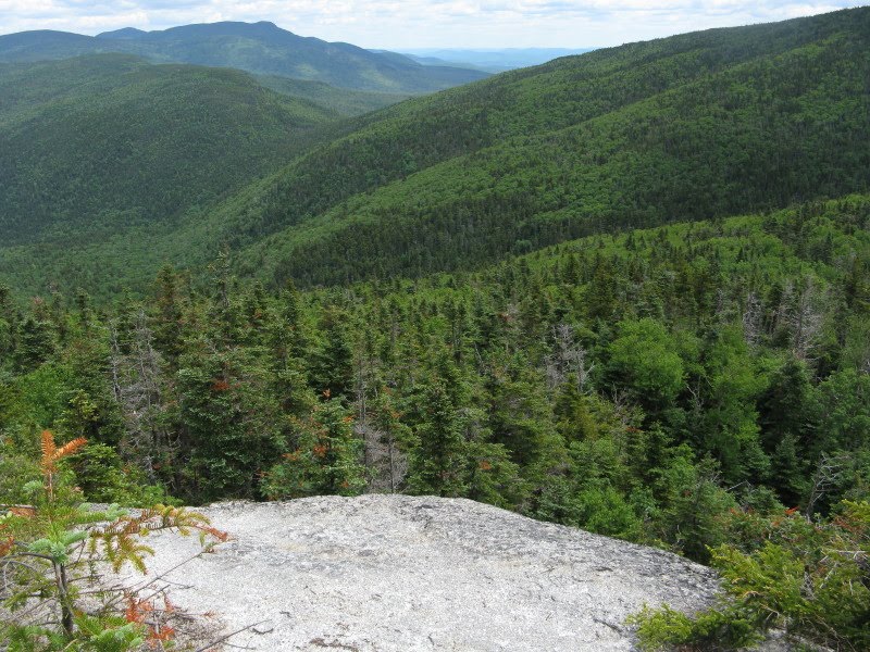
The Noon Peak outlook provides a startling vista down into and across the Drakes Brook valley. In the center is the col between Sandwich Dome and the northern of the two Flat Mountains.
 A second outlook just past the high point of Noon Peak offers another down-look into the valley, and a close look at the great bulk of Sandwich Dome rising 1000 ft. above.
The gentle ridge walk between Noon and Jennings Peaks is one of the highlights of the hike. The Sandwich Mountain Trail was opened in 1879 by AMC members, including Watervillian Arthur L. Goodrich. Arthur's son, Nathaniel, was also an AMC trailmeister and was the godfather of the 4000-footer movement, compiling the original list in 1931. In his 1952 book, The Waterville Valley, Nathaniel wrote a paean to the Sandwich Mountain Trail: "Beyond Noon Peak it passes through an area of curious elfin beauty. Gray ledge and grayer reindeer lichen, green moss and low green spruces, long vistas into mystery, utter quiet, a feeling of remoteness, of simplicity, pervade this spot. Go slowly here."

 Towards the end of this section the trail breaks out onto open ledges; the best views are down to the L. Jennings Peak rises nearby.
The double dome of Sandwich is getting closer.
 An easy climb leads up to the spur path to Jennings.
This side trip is gentle at first, then shoots up a short, steep pitch.

There are two great viewpoints on Jennings. The first is just down on the L, looking NE towards Mt. Whiteface. I enjoyed a leisurely lunch break here.
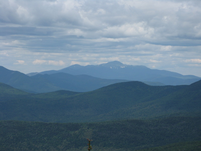
 The Sleepers and Tripyramids, and distant Mt. Washington are seen more to the N.
A panorama of the Sandwich Range high peaks.

The rest of the hike is laid out before you - the broad ridge leading up to the Dome.
 After a while I moved 25 yds. farther to the sunny south ledges of Jennings, which overlook the beautiful Smarts Brook valley and Black Mtn., the great SW shoulder of Sandwich.
 Distant SW vistas expand beyond the cliffs of Sachem Peak.
Sachem, the principal peak of the trailless Acteon Ridge, was described by a 19th century writer as "Chocorua in miniature."

It is an alluring bushwhack objective. Here's the view back up to Jennings from Sachem, with bushwhacking addict Keith D'Alessandro providing foreground interest.

One other spot on Jennings offers a look over the village of Waterville Valley to an array of mountains beyond.

After savoring the Jennings vistas, I returned to the Sandwich Mountain Trail for another favorite section - a gentle, half-mile firs-and-ferns walk along the broad ridge connecting Jennings with the Dome. Sweet sylvan serenity.


The last half-mile to the Dome is a moderate climb, never steep.

The 3980-ft. summit is a small, open ledgy area. In the 1870s it was apparently completely open, and was occupied as a station by the U.S. Coastal Survey. An iron pin can still be seen in the summit ledge. In his 1876 guidebook Moses Sweetser devoted 3 1/2 pages to a description of the Sandwich view, hailing it as "one of the grandest and most fascinating panoramas in New England."
 Scrubby tree growth has closed off the southern view since then, but there is still a magnificent sweep of mountain country to the north.
Mt. Washington dominates the distant northern horizon.
Looking NNW to the Osceolas, with the Franconias on the L and Bond Range to the R.

Looking NW over Jennings Peak to Tecumseh and the Kinsmans.
 Passaconaway and Whiteface peer over the slightly lower NE knob of Sandwich. All told, the summits of 35 NH 4000-footers can be seen from the top of Sandwich Dome.
My plan for the day also included a short bushwhack across the ridge to that NE knob of Sandwich, in the hope of finding some kind of vista towards the Flat Mountain Pond area; the knob blocks the view in that direction from the main summit.

I was expecting some thick going along the ridgecrest, and was prepared to abandon the side trip if it was really bad. To my surprise, and delight, the fir woods were quite open, and there was a faint but discernible moose path which I used much of the way. As always when traveling off trail, I tried to tread as lightly as possible.

There was plenty of poop to keep me on the route.
 This part almost looked like a trail.
From the NE knob I worked carefully and gingerly down a steep slope and found a small opening with just the view I was looking for.

Mt. Whiteface looks over Flat Mountain Pond, with Chocorua securing the eastern horizon.

A zoom on the pond and its remote birch-wooded plateau - one of the most placid settings in the mountains.

I returned to the main summit and descended a short distance on the Sandwich Mountain Trail to the Algonquin Trail junction. About 0.1 mile down this trail there was one more view I wanted to check out.

Where the Algonquin Trail crosses a semi-open ledgy area at 3850 ft., you get a look SW over 3500-ft. Black Mtn. to far horizons.
 To the south you can see Squam Lake, and in the foreground is another interesting side of Sandwich Dome - the low hill-and-beaver meadow country N of Guinea Pond, traversed by the Black Mountain Pond Trail.
Satisfied that I had seen most every side of this great mountain, I climbed back to the Sandwich Mountain Trail, descended a mile, and turned R onto the Drakes Brook Trail for the descent through that pretty valley.

After a fairly steep, switchbacking descent down the W side of the ravine, the trail touches Drakes Brook at a beautiful mossy glen. It was cloudy and late in the day, sorry about the dark lighting.
 For a while the trail closely follows the lovely little brook. This reminded me of the upper valley section of the Sabbaday Brook Trail.
Then the old logging road that the trail follows pulls away from the stream, but still provides pleasant walking.

Lower down in the valley it briefly comes by Drakes Brook again, here a much larger stream. It's a fine trail to descend. The wide brook crossing near the bottom was easy enough this day, but could be quite difficult in high water. The last 0.4 mile follows a wide logging road, passing one scenic open ledgy area on the brook - too dark for decent pictures this evening.
An interesting note: on this partly sunny, cool Wednesday with excellent views, I did not meet a single hiker in 8.7 miles and 9 1/2 hours on the trails and summits.


Awesome write up and pics - looks extremely secluded up there.
ReplyDelete