
I wanted to combine a climb of Mt. Jefferson with "redlining" the section of The Cornice between the Castle Trail and Caps Ridge Trail. With the Jefferson Notch Road still closed due to winter blowdown, the shorter option for this trip from the Caps Ridge trailhead was not available. Rather than wait for the road to open, I decided to do a longer and more strenuous route from the Bowman trailhead on US 2 to the north - up the Castle Trail and down the Israel Ridge Path. This 11 1/2 mile trek would take me along some of the most scenic trails in the Presidentials.
I got an early start on what promised to be a fine day to be above treeline.

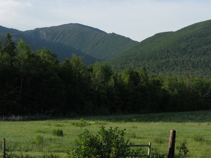
From the trailhead there is a classic view of Mt. Jefferson and the Castellated Ridge, in the venerable words of the AMC White Mountain Guide "sharpest and most salient of the White Mountain ridges."
The first part of the Castle Trail leads through a brushy area and across a powerline to a crossing of the Israel River. The water was higher than I expected, perhaps due to heavy t-storms a couple days earlier, and I had to step on several underwater rocks.
 The next mile and a half of the Castle Trail leads through a leafy hardwood forest, which is especially fine after the Israel Ridge Path splits L and Castle starts to ascend the flank of Mt. Bowman.
The hardwoods extend up to about 2400 ft.

Then white birches take over and the trail becomes steeper and rockier.

The grade is quite steep above 2700 ft., with many rock steps.

At the top of this long pitch, the trail abruptly levels out on the broad shoulder that connects the Castellated Ridge with Mt. Bowman. The next half-mile or so is very pleasant: easy grades, good footing, and ferns galore. This is some of the nicest walking on the Presidentials.


The grade increases as you ease onto the main ridge, but the footing is still decent.
 The ridge becomes much steeper and rougher once you reach the junction with The Link at 4025 ft. Time to stash the trekking pole, lots of scrambling up ahead.
 This steep slab is one of the more interesting spots as you work your way up to The Castles.
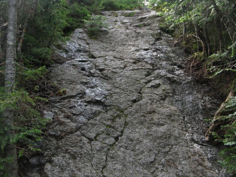
From the first outlook ledge, the First Castle is in sight above.
 Probably the most difficult of the several scrambles on the trail lifts you to the top of the First Castle (4450 ft.). Had to take my pack off for this one and hoist it up.
 This crag is one of the great below-summit viewpoints in the range, whether you look down the valley of Castle Brook....
 ....up the ridge to the higher Castles...
 ...across to the scree-scarred headwall of Castle Ravine...
 ...or out to the western Whites.
Standing on the edge, you get a dramatic look down at the floor of the ravine.
 Across the valley the brown stripes of two recent avalanches could be seen. With binoculars the tree destruction was impressive to see. The left track comes down to the Castle Ravine Trail at one of its many brook crossings, but the RMC trail crew has already cut a route through.
 After an hour on the First Castle, at times dodging some buzzing hornets, I continued up the trail, weaving around the upper Castles and other assorted crags. This is a view back at one of the upper Castles.
As you climb higher, the shark-fin nature of the ridge becomes more apparent.
 Higher up, the "Adams family" comes into view to the NE.
 It's a steady climb, all in the open, leading up through rough talus as the summit of Jefferson rises ahead.
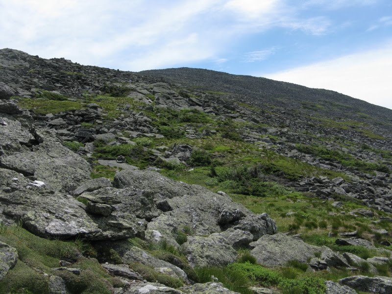
The Cornice junction is reached at 4.5 miles and 5100 ft. The section of this trail from here to the Caps Ridge Trail was the last bit of trail I hadn't done in the Presidentials.

There's a reason I put this one off for so long. This entire stretch is a sidehill rock-hop across jumbles of talus. Cornice is not really a trail, just a route marked by cairns across the boulders.

It's slow and tedious, every step carefully placed, with the occasional loose boulder to test your balance.

The views are, naturally, continuous, with the Dartmouth Range sprawling nearby to the west, beyond Jefferson Notch.
 As you work your way around the flank of the mountain, the Caps Ridge appears. Still a ways to go, though.
 It took me an hour plus to do the stretch across to Caps Ridge Trail, at a cautious pace. The Cornice would be a very bad place to break a leg.
Here there were views of the western slopes of the range.

I dislike the boulder slog up the cone of Jefferson on Caps Ridge Trail. I opted for the longer but easier trek on the more hiker-friendly southern leg of Cornice, Gulfside Trail, and Mt. Jefferson Loop. This part of the Cornice rises at a moderate grade, with improved footing.

There's an interesting view across the sedgy slope to the ragged crest of Jefferson.
 After a short stint on Gulfside, I headed up the Jefferson Loop, which provides a moderate climb with decent footing, starting on the flats of Monticello Lawn.
 Looking back across the lawn to Mt. Washington and the gouge of the Great Gulf headwall.
The summit is in sight ahead beyond some quartz outcrops.
 A massive cairn marks the four-way trail junction just below the summit of Jefferson.
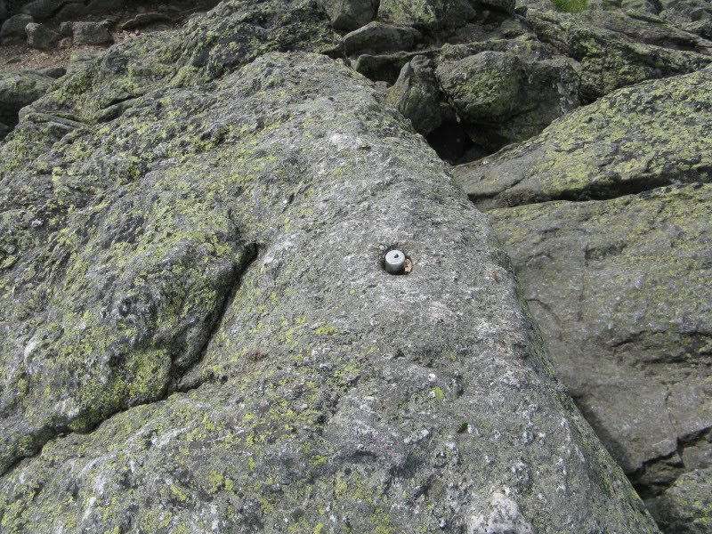
The true summit is reached by a short rocky scramble up from the high point of the Caps Ridge Trail.

A metal pin marks the highest outcrop.
Although it is not often ranked among the top several viewpoints in the Whites, there are plenty of interesting vistas to be found on Jefferson. From here, the summits of 40 other NH 4000-footers can be spotted. Most notable are the two highest peaks in the Northeast, both near neighbors to Jefferson, the third highest at 5716 ft. Mt. Adams (5799 ft.) is to the NE....

...and Mt. Washington (6288 ft.) to the south.

The Carter Range is seen to the east, beyond a lesser summit knob.

The southwestern panorama reveals wave after wave of blue ridges.
 While I was lounging at the summit, three hikers active on the "Views from the Top" internet forum came up: Silverfox, Cymbidium and Loanshark (L to R). For readers not familiar with this site, it is a great resource for hiking information (www.viewsfromthetop.com). Most hikers who post on the forum take trail names, much like Appalachian Trail thru-hikers. This hardy trio had climbed over Mts. Madison and Adams en route to Jefferson, and were now heading down to the Jewell Trail and a car spotted at the Cog Railway Base Road.
 After a relaxing summit stay, with a breeze mostly keeping the hornets and assorted other insects at bay, I headed north down the Jefferson Loop. It was late in the afternoon, and the trails were mostly deserted. In fact, I had met only one hiker all day until I was near the summit of Jefferson.
As you descend, the view of Adams rising from the depths of Jefferson Ravine is dramatic - one of the outstanding sights in the Whites.

There is an open bog on the floor of Jefferson Ravine. Wouldn't that be a neat, challenging snowshoe bushwhack destination (when avalanche danger is low).

As I descended along the Gulfside Trail towards Edmands Col, a lingering snowfield could be seen ahead. The outcrop known as Dingmaul Rock is visible just below the center of the photo.

There was a well-beaten but shallow track across this firm, old, slippery snow. The exit on the downhill side was actually rather delicate; for two steps I wished I had my Microspikes.

There's a striking vista into Jefferson Ravine from Dingmaul Rock.

After a steep, rough descent below Dingmaul Rock, I eased down to Edmands Col.

Next up was an open 0.7 mile traverse on the Randolph Path, leading across the rim of Castle Ravine to the Israel Ridge Path.
 Although the lower few miles of Randolph Path are nice and graded with pretty good footing, this upper section is often rocky and rough. Better than the bad Cornice segment, but still fairly slow going for a nearly level route.
Continuous views through here, looking down into Castle Ravine...

...across at the Castellated Ridge....

...and back at the summit of Jefferson.

I turned L for the descent on the wild, rough and scenic Israel Ridge Path, soon descending into the scrub. Sadly, I had not left time for the short side trip to Emerald Bluff, a great viewpoint on the Emerald Trail. (See posting from September 8, 2009, "Peering into Castle Ravine," for a trek including Emerald Bluff.)

The RMC trail crew has constructed several ladders to span steep ledges.

The descent off the lower end of Israel Ridge is very steep. This minor ridge was originally called the Emerald Tongue; apparently the great path-maker J. Rayner Edmands applied the new name when he constructed the Israel Ridge Path in the 1890s.

I took a break at one of my favorite spots in the mountains: the ledges beside the Second Cascade on Cascade Brook, with Mt. Bowman rising nearby. This is a great destination for a moderate hike of 5 1/2 to 6 1/2 miles round trip, depending on the route chosen. The trail is rather rough in the vicinity of the Second Cascade, and also by the First Cascade a short distance downstream.


As often happens when I take a long and leisurely hike in the Northern Presidentials, I came out in the dark. When I stopped to pull out my headlamp about 3/4 mile from the trailhead, a hiker who had passed me just a half-mile in early in the morning came up behind me. When he recounted his itinerary for the day, I was astounded, and felt rather wimpy for being as tired as I was after 11 miles: up the headwall of Castle Ravine, down to the Log Cabin along Lowe's Path, up Spur Trail and others to Mt. Adams, back down to Edmands Col, across the two worst parts of Cornice, down Caps Ridge to The Link, across the notorious section of the Link to Castle Trail, back down into Castle Ravine and across to Israel Ridge and then, finally, down. (Hope I remembered this correctly.)
It turns out he was Curtis Moore, who has worked several seasons for the Randolph Mountain Club, most recently for two years as Field Supervisor for the trail crew. This is the 100th Anniversary of the founding of the RMC. (The main reason the club was formed was to restore the many trails on the Northern Peaks that had been obliterated by heavy logging around 1903-1907.) One of the centennial doings is the 100 Miles in 100 Years Challenge: walking all 100 miles of RMC-maintained trails. The middle section of Cornice was the last section I needed, having done all the others over the last 30 years. Curtis, on the other hand, was aiming to do the 100 miles in four days! That would be an impressive feat indeed, as there are many rough and rugged paths in the RMC system. Hope he can do it.
For more information on the RMC and its centennial, visit www.randolphmountainclub.org

And I was cleaning waterbars and blowdowns on the Jewell trail this very same day. Didn't see the three you mentioned though. I must have left before they headed down. I still need to do the Cornice. Getting closer Steve aren't you?
ReplyDeleteJohn
What a hike!
ReplyDeleteFrom looking at your photos, it looks like you had fabulous weather above tree-line.
And regarding the redlining of the section of The Cornice between the Castle Trail and Caps Ridge Trail, would it be fair to say that this will likely be a once in a lifetime event?! :))
Terrific report and photos, as always Steve!
John
1HappyHiker
John G: I think they left the summit around 3:45, so they would have come down fairly late on Jewell. Have you guys adopted that trail, too? Good work!
ReplyDeleteSteve
John/1HH: Thanks, it was a great day with maximum hours above treeline. For sure, it is highly unlikely I will set foot on that middle part of the Cornice again.
ReplyDeleteSteve
My daughter Tyler and I went up Castle, took Cornice to Randolph and down Isreal ridge, with a memorable stop at Emerald Bluff, combing some of this blog with your other post on Castle ravine. Thanks for the inspiration!
ReplyDeleteMy daughter Tyler and I went up Castle, took Cornice to Randolph and down Isreal ridge, with a memorable stop at Emerald Bluff, combing some of this blog with your other post on Castle ravine. Thanks for the inspiration!
ReplyDeleteSounds like a great trip! Emerald Bluff is one of my favorite spots.
Delete