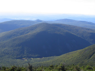
A favorite "local" hike on the western side of the White Mountains is the easy stroll into Tunnel Brook Notch - the deep, steep gap between Mt. Moosilauke and Mt. Clough - on the Tunnel Brook Trail. The scenery in this wonderful pocket of wild country is a unique combination of beaver ponds and slides. The half-mile stretch along the floor of the notch has an openness that is unusual for a valley trail. Seen below is a perspective of the notch from the northeast, taken on a 2008 bushwhack up a western spur ridge of Moosilauke.

A more commonly seen bird's eye view of the notch is enjoyed from Moosilauke's South Peak.

With rain once again in the forecast for the afternoon, I got out for an early start, before 7 am, from the north end of Tunnel Brook Trail at the end of Tunnel Brook Road off Route 112.

About 0.8 mile in the easy-graded trail passes an old logging camp on the left. Not much to be found here, just a few scraps of metal.

On the other side of the trail from the camp, Tunnel Brook flows through a pretty beaver meadow. The slope of Mt. Clough's north ridge rises to the west.

Looking south, you can see the west slope of Moosilauke.

Just beyond is the first of two crossings of Tunnel Brook; both are supplied with good step stones.

The trail runs up and down through outwash from slides, passing this finely crafted cairn.

After the second brook crossing (1.3 miles), the trail reaches the long string of beaver ponds on the floor of the notch. From the first ponds there's a great view up to the massive slides on the steep east face of Mt. Clough. These are thought to have fallen during the great rainstorm in November 1927. Before the slides, there was a crude road - passable for automobiles - through the notch.

On several previous trips I've scrambled (steeply!) up to a perch on one of the the larger slides, where there's is a neat view looking down at some of the ponds.


As the trail continues through the notch, it passes more ponds with views up to the slides from different perspectives.

The view looking north up the notch.

Tunnel Brook is crossed partway along the ponds, via an old beaver dam.

The next pond is tucked in against the slope of Moosilauke.

Still another pond provides the first view up to Moosilauke's South Peak...

....and south down the notch.

One section of the trail is a nice corridor through conifers.

The southernmost and largest pond is called Mud Pond. From its edge there's a fine view up to South Peak and the slides in Slide Brook ravine.

From here I bushwhacked up the remnants of the southernmost slide on Mt. Clough. Only a few open patches remain on this slide.

This was steep, thick and rough terrain.

On the uppermost open area I found a good ledge perch.

From here I looked directly across at South Peak and Slide Brook ravine rising above Mud Pond.

The largest slide is quite impressive. Back in the 90s I whacked up to this one; it was very steep with hardpacked gravel that provided poor footing. The view down to the ponds and the Clough slides was excellent.

After a nice break, with some unexpected hazy sun, I made a laborious descent to the trail, probing every foot placement carefully. There were many hidden holes that could swallow a leg. Once back on the trail, I followed it south over the broad height-of-land and down a little ways until it came near Slide Brook. Then I whacked up the brook, looking for cascades. Anyone hiking in the Slide Brook area, on the southern part of Tunnel Brook Trail or off it, should remember that this stream is the water supply for the Glencliff Home - don't pollute!

Perhaps a half-mile upstream were two adjacent cascades, small but attractive.


I headed back down towards Mud Pond through fine open hardwoods.

The grassy south end of the pond offered a different perspective on the pond and the notch. Light rain started falling soon after I got back to the trail - good timing!


Last September, while completing a similar modest bushwhack loop partway up Slide Brook and then back to Mud Pond, I was greeted by a chorus of coyote howls when I reached the east side of Mud Pond, with just an hour of daylight left. The coyotes were on the west side of the pond, on the Tunnel Brook Trail, and I spotted them when they emerged in an opening along the shore. It was just me and them in this suddenly wilder notch. I decided not to return to the trail by Mud Pond, where the pack was hanging out. Instead I whacked north through woods, meadows and swamps along the east side of the beaver ponds. I eventually made my way back across to the trail on a grassy beaver dam, well north of Mud Pond. A most interesting conclusion to the trip.

Hey Steve,
ReplyDeleteGreat story. We hiked this a number of years ago in early winter, no snowhoes necessary. What a beautiful area with all the beaver ponds frozen. We had a blast hiking this. We did a thru hike to the road on the other side and then back. Lots of fun.
John