A crisp spring day, with 100-mile visibility reported by the Mt. Washington Observatory, called out for a hike to a high peak with far-reaching views. I hadn't been up Mt. Flume in four years, and I've always liked the Osseo Trail, so after a short drive from home I was on my way up the Lincoln Woods Trail. The washout along the East Branch 0.7 mile from the trailhead is getting worse, and the Forest Service has plans to fix it this summer. Note that the project listing states that the first 0.7 mile of Lincoln Woods Trail could be closed for 9-12 weeks during the project, which will involve major excavation equipment, probably during low water time in late summer. This will obviously impact hikes to Owl's Head, 13 Falls, the Bonds, Flume via Osseo, and the Pemi Loop, so hikers should plan accordingly.
Onto the Osseo.
The trail makes a long approach up the valley of Osseo Brook, but only comes close to it in the first 0.2 mile.
A partly buried bed frame from Camp 8 of the East Branch & Lincoln Railroad.
Partway up the valley, the trail follows one switchback of a gravity-powered incline logging railroad built by the J.E. Henry logging operation in 1901. This line only operated for a couple of years; it was abandoned when a brakeman was killed after a car loaded with logs careened out of control on the way down. I believe this is the switchback the incline railroad followed down below the trail, towards the floor of the valley.
Most of the first two miles of Osseo are at easy grades with good footing, paralleling Osseo Brook up its long valley. I walked this trail shortly after it was opened in 1983, replacing the original Osseo Trail over Whaleback Mtn., which was abandoned due to condo construction on its lower section. (Osseo, supposedly meaning "Son of the Evening Star," is another name for Whaleback Mountain.) I remember the soft duff footing down most of the length of the trail. It's rougher and more eroded now up on the ridge, but those lower two miles are still pretty smooth sailing.
Four decades of hiker traffic and many heavy rainfalls have taken their toll in places on the ridgecrest part of the trail.
The obligatory Osseo ladder/staircase shot as it climbs up the narrow and precipitous nose of this spur ridge. Every time I hike this trail I'm amazed at the steep and rugged terrain it negotiates.
At 4.6 miles from the parking lot, elevation 3500 ft., is this notable viewpoint.
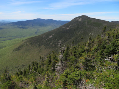
A great vista across the Pemigewasset Wilderness, surging with spring greens in the valleys. The Twin-Bond Range takes center stage, with Owl's Head in a supporting role on the left.
Mt. Flume is still a a mile away and 800 ft. higher.
More ladders above the Downlook.
At the top of these, a short side path on the left leads to a stunning viewpoint looking SE down the curving Osseo Brook valley to multiple peaks on the horizon.
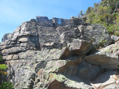
Zoom on a monster slab that adorns the slope on the south side of the valley.
Above the ladders the trail levels on a scrubby shoulder with many black spruces.
Before heading to the summit, I spent some time at a crag to the south accessed by a side path at the very top of the Flume Slide Trail.
Like the summit ledges, this crag has a magnificent view down into the Flume Brook valley and out to Mt. Moosilauke, the Kinsmans and distant horizons. The 100-mile visibility revealed such far-off peaks as Mt. Monadnock, Stratton Mountain, Mts. Abraham and Ellen, and Mt. Mansfield.
And it was an Adirondack day, with the broad bulk of Dix Mountain seen beyond the Green Mountains, through Lincoln Gap.
The sharp profile of Mt. Liberty.
A hiker takes in the view from the top of Liberty.
As you approach the summit of Flume on the Franconia Ridge Trail, crags on the left provide a striking profile of the west-facing cliffs, with Mts. Lincoln and Lafayette beyond.
Looking down the Flume slides, most of which came crashing down in a June 1883 rainstorm.
Peering down a gully from the trail.
You clamber up blocky ledges to access the summit crest.
Looking back to the south.
The ragged, rocky crest of Flume may be the coolest summit in the Whites.
Looking back across.
For views east into the Pemi, you have to stand and peer over or between the trees. Here there is a long look up the East Branch valley to the Nancy Range.
The upper Franconia Range and Mt. Garfield. By moving around, one can spot the summits of 33 NH 4000-footers.
Peering straight down from the summit crags. On this crystal-clear day it was great to spend a couple of hours enjoying the views from different perspectives around the summit area.
On the way down the Osseo Trail, a view into the slide-scarred basin of Redrock Brook from the Downlook.
Parting view of the Bonds, displaying the "Guitar Slide" on West Bond and a 2011 Irene slide on the flank of Mt. Bond. The Osseo Trail route to Mt. Flume is 11.2 miles round trip with 3150 ft. of elevation gain.


Thanks so much. Love the historical details. Also, I woulda never thunk that Flume had such a view, e.g., of 33 of the 48 4K peaks.
ReplyDelete