
On this glorious spring day I had two objectives: get a TLF (Trout Lily Fix) in the hardwood forest on the lower Flume Slide Trail, and climb to the top of the 1883-vintage south slide on Mt. Liberty, which I had visited last winter, but not to the top.
After an approach via the Franconia Notch bike path and lower Liberty Spring Trail, I turned onto the Flume Slide trail and soon entered the peaceful realm of the Flume Brook valley.

I was immediately rewarded with an abundance of Trout Lily sightings.

In places the forest floor was carpeted with them.
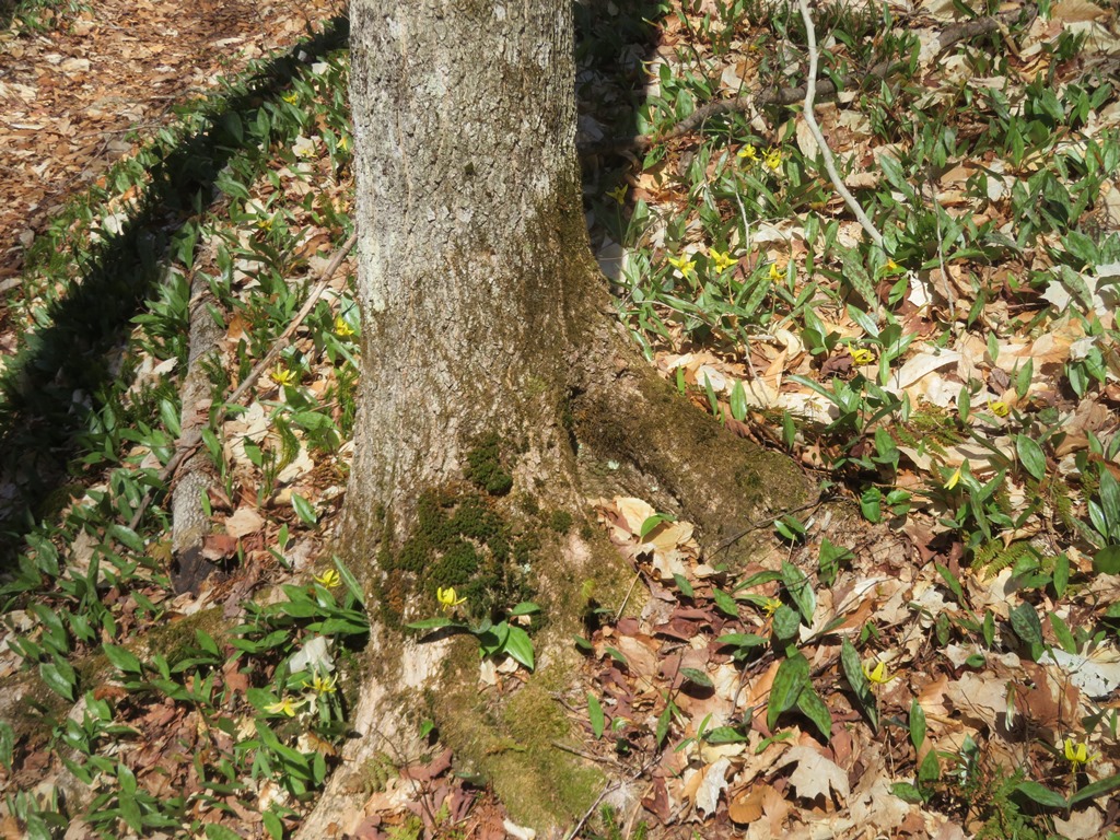
There are some large old trees in this fine hardwood forest.

One of two clusters of Spring Beauties spotted along the trail.

A Red Trillium is ready to bloom next to its Trout Lily neighbors.

Mt. Flume looms through the trees.

Just before crossing the brook that drains from the Mt. Liberty slide, the trail looks down on what appears to be a gullied track carved out by a branch of the slide when it (along with massive slides on Mt. Flume) came crashing down during a rainstorm on June 20, 1883. The Mt. Liberty slide swept away one of the famed landmarks of Franconia Notch - the large boulder suspended between the walls of the Flume. This natural disaster received widespread coverage in the media, including a dramatic illustration on the cover of the popular Harper’s Weekly. Henry M. Burt, publisher of Among the Clouds, the Mt. Washington summit newspaper, wrote a 38-page pamphlet about the slides in 1883: The boulder and the flume. The Franconia avalanche. A geological revelation. Burt noted that there was a long rumbling sound following a clap of thunder, and people living down the valley thought it was an earthquake.

The trail's crossing of the brook that drains from the slide.

Beyond the brook crossing I launched my whack to the slide, at first through open hardwoods.

I then picked up the track of an old logging road, part of a remarkable network constructed on the south side of Mt. Liberty, probably around 1900-1905.

In places the road was strewn with blowdowns.

Higher up, parts of the road were mostly clear. Up here it rose very sharply - more steeply than it appears in the photo. It's hard to imagine horses hauling logs down this kind of a grade. Perhaps some sort of cable system was used.

Then I followed a branching road out towards the slide. I was very pleased that snow and ice were almost totally absent here at 3200 ft. on this south-facing slope.

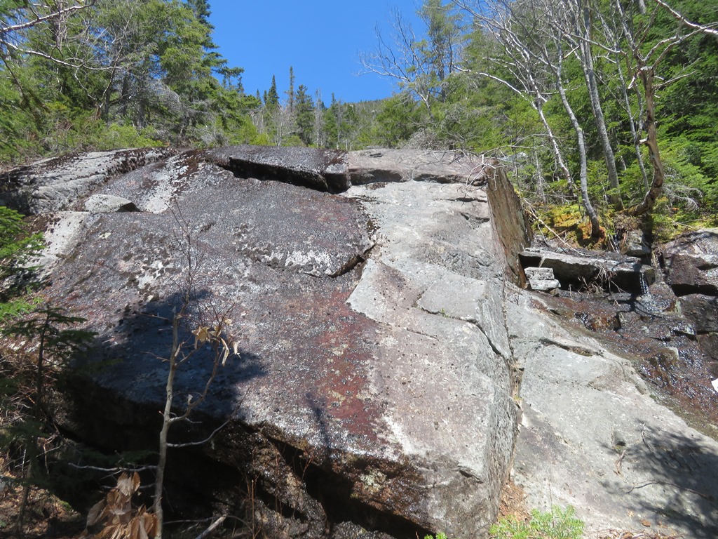
The Liberty slide has three open sections separated by belts of scrub. I emerged halfway along the edge of the lower open section. As expected, the steep slabs were dangerously wet and slick, and not suitable to climb (for me, at least).
A vivid description of the Liberty slide appeared in the August 28, 1897 issue of The White Mountain Echo and Tourists’ Register, published in Bethlehem, NH. The unidentified author (perhaps the paper’s editor, Markinfield Addey) wrote that the slide occurred during a torrential downpour accompanied by frequent thunder and lightning, following two days of steady rain. An “ominous crash and awful rumbling…alarmed the inmates at the Flume House, and was perceptible at Bethlehem, seventeen miles away.” The writer reported that the slide had left a channel thirty feet deep and from twenty to 200 feet side, and that trees were cleared from a swath 500 feet wide and a mile long. The slide entered Flume Brook from the north. The “fierce torrent” of water, earth, rock and tree swept down through the Flume in a “wild dance of destruction,” scouring and deepening it and sweeping the suspended boulder away. It also created two new waterfalls, including Avalanche Falls at the head of what the writer called the “New Flume.”

The upper end of the lower swath.

A cliff-like headwall divides the lower and middle sections of the slide. In winter this is an impressive ice cliff.

A shelf at the base of the headwall provided a safe place to cross the slide to the other (north) side.

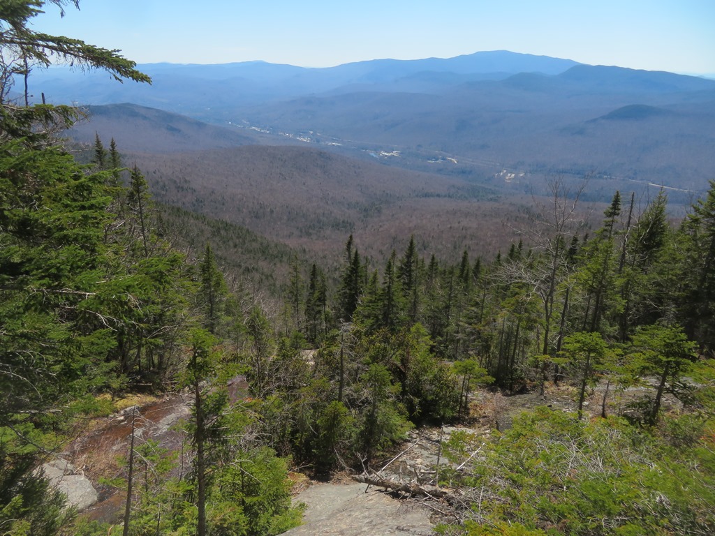
View out to the Pemigewasset valley and Mt. Moosilauke from the top of the lower swath of the slide.

The portion of the ice cliff in the woods was still hanging on. This appeared as a white speck beside the slide when viewing Mt. Liberty from the parking lot at Indian Head Resort.

Heading steeply up beside the slide through prickly conifers.

A second headwall between the lower and middle sections of the slide.
I carefully made my way to a gently sloping slab at the base of the middle section. The dry strip in the middle looked tempting but it was quite steep and a boot test revealed that the ledge was smooth and not especially grippy. Slides have a way of luring you into spots that are steeper and more difficult than they look, so I opted not to scramble up here and potentially get stuck partway up.

From this spot I had an interesting angle on the sharp peak of Big Coolidge Mountain.

I made my way up briefly along the edge of the middle section, then headed back into the woods.

I made a short detour to the north for a view of an impressive slab that runs parallel to the main slide.

The upper edge was cloaked in colorful moss.

Looking down from a vantage higher up along the middle section of the slide.

I worked my way up and around to a great perch at the base of the upper open swath of the slide.

Here there was a comfortable dry seat and a commanding view over the valley and out to Mt. Moosilauke and distant horizons.
Zoom on the Flume Visitor Center, where I parked.

Zoom on a crag higher up on the steep SW slope of Mt. Liberty.

To get to the top of the open slide, some Type 2 fun in the woods was required.

No way was I going out there.

Yikes! The average pitch of this slide is a respectable 31 degrees, as measured on NH Granit.

Another perspective looking down.

The headwall at the top of the open slide.

On the headwall.

Down-look from the headwall, at 3600 ft.

View from the headwall.

I climbed a little higher above the headwall, and came upon the day's obligatory balloon.

Above the headwall the slide is much narrower and more closed in.

A deliberate and careful descent. My arms were burning with scratches after this whack. Long sleeves next time.

I looped a bit out to the north and visited another slab parallel to the main slide.

Roof rock in the woods.

Random cliff. A rugged area!

Back down to the headwall atop the slide's lower section.

Evening sun illuminates Red Trilliums along the Flume Slide Trail.

Last sun in the hardwoods.


No comments:
Post a Comment