On a brisk and breezy spring day after a significant snowfall on the higher peaks to the north, I enjoyed a 99.9% snow-free bushwhack through endless hardwood forest on the 2800-ft. western extension of Tripyramid's Scaur Ridge.
Another bright spring day on the Livermore Trail.
Leaving the trail about 2 miles in, I headed north into the hardwoods, with the crest of Scaur Ridge visible ahead, 1000 ft. above.
Not far in, I crossed an interesting flat, wet area with meandering little streams.
Fine specimens of yellow birch and white ash, side-by-side.
Halfway up the slope I came to a remarkable flat shelf that I had noted on the 2-foot contour LiDAR map on the NH Granit website.
Many interesting rock formations in this area.
It looks like a wide old logging road, but this appears to be a natural corridor along the shelf.
Mossy ledge face on the uphill side.
Neat jumble of boulders.
Standing tall in a little bowl on the mountainside, this is likely one of the largest yellow birches in the valley.
The massive trunk of the yellow birch.
A mossy stream wanders down the mountainside.
Another giant yellow birch, with Mt. Tripyramid in the background.
Capacious crown.
Higher up on the ridge, the woods have a different look on a rocky, ledgy slope.
The woods were consistently open on this bushwhack, allowing occasional peeks at Tripyramid.
The entire slope was carpeted with untold thousand of trout lily leaves, though none were yet in bloom. I did spot these emerging leaves of what look to be Dutchman's Breeches.
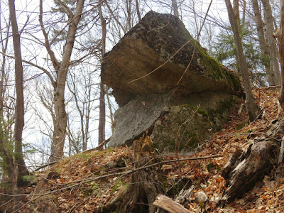
Jaws.
Approaching the ridgecrest through twisted, weather-wracked trees.
I poked around in a steep patch of spruce in search of a small viewpoint I had found on a snowshoe trek fifteen years ago. I eventually found this small clifftop vantage point, though I'm not sure it was the same exact spot.
Here was a nice framed view of Sandwich Dome and Jennings Peak behind Snows Mountain, though the darn camera focused on the branch instead of the mountain.
Scrambling back up to the ridgecrest through some crazy terrain.
I ranged along the SE edge of the ridge, looking for views, and found a nice look at North Tripyramid and the mostly bare North Slide.
From another clifftop I peered out at the broad crests of Snows Mountain and the northern Flat Mountain, with double-domed Sandwich to the right.
This boulder rests right atop the middle of the ridgecrest.
Stunted beeches populate this 2800-ft. crest.
Heading west along the ridge, I made a careful descent of this steep, rocky slope.
Another shelf that looks like an old logging road, but appears to be a natural corridor.
Farther along the ridge I picked up Irene's Path and followed it for 0.6 mile.
Waterville Valley's ever-impressive Rock of Gibraltar.


Thanks, Steve. Those jaws look like a hippo's!
ReplyDelete