
On a fairly cold but sunny and nearly windless day I snowshoe-bushwhacked to the south slide of Mt. Liberty. This slide, which fell in 1883 in the same storm as the great slide on Mt. Flume that swept the famous suspended boulder out of the Flume Gorge, is prominent in the view of Mt. Liberty from Mt. Moosilauke, as seen below. It's also highly visible as you drive up US 3 or I-93 into Franconia Notch, and can be viewed from the area of the Flume Visitor Center.

From the northbound Basin parking area I made my way to the start of the Flume Slide Trail.

As seems to be the norm this winter more than ever, a soft snowshoe track had been chopped up by barebooters, some wearing crampons (!) in the soft snow. I smoothed it out somewhat with my two passes over it in snowshoes.

The lower part of Flume Slide Trail is a pleasant walk through a fine hardwood forest, especially on a sunny winter day.

At 1.5 miles from the Liberty Spring junction the Flume Slide Trail crosses the brook that drains from the Liberty slide.

On the far side of the drainage I headed off-trail, through hardwoods for a short distance.

A study of Lidar hillshade and contour maps revealed an amazing network of sled roads from an early 1900s logging operation on the south slopes of Mt. Liberty. I soon came to the first of these and followed it partway into the ravine. I soon determined that this was not the main sled road I was seeking, one which leads high up onto the slope parallel to the drainage.

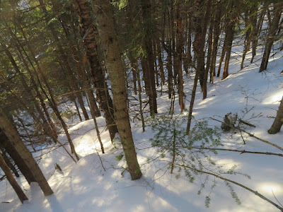
I whacked a ways up the slope and eventually found the desired road. From experiences with old sled roads on Mt. Osceola and elsewhere, I feared this century-old logger's thoroughfare might be choked with small snow-laden conifers mixed with blowdown. At first there was a bit of that.

But soon the road opened up, reflecting the open "salt-and-pepper" woods spreading across this slope.

The breaking was slow and heavy, but the route was turning out to be far better than expected.

Detour around a blowdown.

A marvelous corridor through the forest.

Plenty o' snow in here.

The road goes ever on...

High up on the slope I turned left onto a side sled road that traverses up and across the slope towards the slide.

Looking back along the side road.

I had turned off the main sled road one side road too soon, and ended up peering into the narrow, steep-sided gully of the slide track, 100 ft. in elevation below the open part of the slide.

I made a steep bushwhack through mostly open woods to get up to the slide proper.

There are three open sections of this slide. I emerged into brilliant sun at the bottom of the lower open section. Though the day's Mount Washington Avalanche Center forecast was for Low avalanche danger at all levels, I deemed the steepness of the slope and snow depth here a little chancy for ascending in the open, so I went back into the woods and climbed parallel to the slide.

Side view.

Near the top of the lower open swath of the slide, I emerged at a lower-angle slope for a view down into the Pemigewasset valley and out to Mt. Moosilauke.

Peering down at the Flume Visitor Center. The sun was wonderfully warm here and I could have lingered for an hour
or more. But it had taken a long time to get up here, and I wanted to
explore higher on the slide.

After a late lunch break I worked my way up to the base of an ice cliff at the top of the lower swath.

To get to the next open section of the slide, I made a flanking maneuver around the continuing band of ice bulges.

After another steep climb through the woods, I came out at the base of the middle open section of the slide.

Side view with another ice bulge. A report from a summer adventurer indicated that the ledge slabs of this slide are soaking wet and unsafe to climb in that season.

A zoom on crags higher up the ridge, beyond the upper part of the slide.

I ascended in the open along the climber's left side of this section, where the slope angle and snow depth were more moderate. Views expanded as I zigzagged my way up.

From the top of the middle section I could look up the topmost swath of the slide. Had I another hour it would have been tempting to continue to the upper end. But it was 3:30 pm and I had a long descent back to the trail.

From this spot, a commanding view! After taking it in for a few minutes, I headed back down along my tracks.

Ice sculpture in the forest.

Taking a different route down through the woods.
Looking back up a higher side sled road that I followed to get back to the main road.

Homeward bound.

This 1920s postcard shows the slide (upper right) about 40 years after it fell. Remarkably, it also reveals the lower part of the main sled road I followed parallel to the drainage. Higher up, some of the traversing sled roads can also be seen.


Steve, fantastic report and stunning photos!
ReplyDeleteThanks, Steve - glad you enjoyed it - 'twas a memorable day!
ReplyDeleteA few months before you were there, I tried pushing through the start of the logging path network on what looked like the main path, and turned around on account of how thick it was with spruce. I was aiming for the bluffs above your highest photos. Guess I should have kept going! Thanks for posting.
ReplyDeleteThe logging road approach was great. Above there it gets a bit gnarly!
Delete