A variety of interesting features highlighted this trek in the Sandwich Notch and Black Mountain Pond area. The route into the Sandwich Range Wilderness was a combination of road walking, old woods roads, herd paths, trails and bushwhacking.
Strolling along the historic Sandwich Notch Road, originally built in 1803 to link the village of Sandwich with Thornton and Campton. For about fifty years it served as an important transportation route for the many hill farms scattered across Sandwich Notch. Most of these farms were abandoned by the time of the Civil War. Today the road is maintained in a rough and primitive state, best for high clearance vehicles. As detailed in two booklets published by the Sandwich Historical Society, many cellar holes, foundations, stone walls and other remnants of the hill farm community can be found in the woods.
Tracing the early 19th century North Road, which cut across eastward from the Notch Road, leading behind Guinea Pond and continuing across to the north of Mt. Israel.
Beautiful maple forest in here.
A barn foundation, which was presumably part of the farm of the Durgin family, who also operated a modest tavern nearby on the Notch Road.
One of many stone walls in the area.
A pile of stones suggests that this land was once cleared for pasture.
A protruding sled runner at the site of an old logging camp near the Algonquin Trail.
Algonquin Brook.
A ledgy cascade.
More cascades above.
Whacking through open hemlock forest.
Moose sign.
A remote beaver meadow on a plateau south of Black Mountain Pond.
Forever-wild hardwood forest.
Camping is restricted at Black Mountain Pond due to past overuse. The WMNF removed the shore-side shelter some years ago.
Black Mountain Pond is a backcountry beauty.
Rhodora at pond's edge.
New signage at a confusing spot in the woods above the pond.
The larger of two tentpads near the pond.
Revegetation efforts are ongoing.
A ledge seat at the water's edge, with Black Mountain, the massive SW shoulder of Sandwich Dome, looming beyond.
Another angle on Black Mountain.
Ragged cliffs of tough metamorphic rock.
Spring foliage between water and sky.
Zooming in on a bushwhack objective - an open fern and birch glade with potential views, high on a shoulder of Black Mountain.
After rock-hopping along the shore, a view south across the watery expanse.
Bushwhacking up through open, rock-strewn hardwoods.
A beautiful glade graces a small plateau.
Joined at the hip.
Dreamy bushwhacking.
Higher up the shoulder I entered a series of open glades peppered with dead and dying birches.
A stout yellow birch standing alone.
These glades have rocks in abundance.
First views back, looking south to the Squam Range.
Mt. Israel and Dinsmore Mountain.
A steep pitch leading to the upper and most open glade.
Into the glade.
Amazing place!
An upturned rootball had opened up a nice seat at the top.
Looking south.
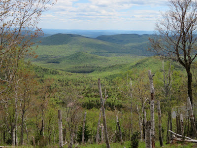
The upper Beebe River valley is a broad scoop leading out towards Dinsmore Mountain and the north end of the Squam Range.
The Ossipee Range to the southeast.
Ledges below the glade offered even wider views.
The Campton Range on the other side of Sandwich Notch.
A vast sweep to the southwest beyond Black Mountain Pond. It was clear enough to see Mt. Monadnock on the horizon.
Bird's eye vista from a nice angle.
Descending through the rocky glades.
A cluster of Clintonia.
Late afternoon at Black Mountain Pond.
Beaver meadow on Algonquin Brook.


No comments:
Post a Comment