I took a long, leisurely ramble up the beautiful Sabbaday Brook valley on a hot and sunny Fourth of July. There was lots of nice scenery along the cool waters of Sabbaday Brook. Along the way I visited the sites of three old logging camps and enjoyed views from vestigial open patches on two old slides.
It was in the 60s when I set out in the morning. Later in the day it hit 93 degrees in Lincoln.
The Sabbaday Brook Trail recently reopened after the construction of new railings along the walkways beside Sabbaday Falls.
Into the Wilderness near the start of a section of trail that follows a century-old logging road for 1.6 miles along the east side of the brook.
A couple of years ago, the AMC trail crew (under contract with the WMNF) built some fine rock waterbars and rock steps along this section. Interestingly, in 1880 AMC volunteers scouted a possible route up Sabbaday Brook to Tripyramid, and marked it almost to the base of the steep climb at the end. But the distance to the summits was greater than expected, and the potential cost of building the path and clearing summit views was so great that it was deemed best to postpone the project. The Sabbaday Brook Trail basically developed from trampers using the route of the Swift River Railroad tote roads to the base of the mountain, and then the East Slide and a rough connecting path to the top of the ridge. In the 1920s and 1930s this route was maintained by the Passaconaway Mountain Club, based at the Swift River Inn in Albany Intervale. After the PMC faded away with the closing of the inn, maintenance was assumed by the WMNF.
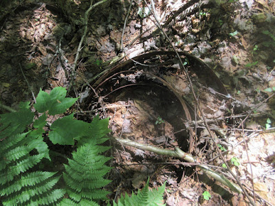
Thanks to intel from Ben English, Jr. - longtime White Mountain tramper, history buff and AMC trail crew guru - I found this half-buried cookstove at the site of the Holland Camp. This camp was operated by the Conway Lumber Company's Swift River Railroad during the decade of 1906-1916.
Front view.
Noyes & Goddard manufactured cookstoves in Waterville, ME from 1886 to 1902. The company sold about 1,200 cookstoves per year and employed 15 men in the shop plus 8 salesmen.
The logging road that the trail follows along the east bank was well-constructed and was the main route for hauling logs out of the upper valley. No railroad line was built into the Sabbaday Brook valley.
Farther up the valley I poked around the site of the Monahan Camp. The variety of artifacts here included these hoops from a barrel that probably rotted away. (Please note that these artifacts are protected and it is illegal to remove them from the WMNF.)
A bowl shaded by hobblebush leaves.
The "Magnetic Pearl" was a small cookstove manufactured by Southard, Robertson & Company of New York City. It had four holes and was designed to be used with either coal or wood.
This may be the stove from which the door in the previous picture was detached.
The Sabbaday Brook Trail is magical as it meanders through the secluded upper valley, hemmed in by the Fool Killer, Mt. Tripyramid and West Sleeper.
In the 1920s AMC Guides mentioned that there was yet another logging camp along this branch road, 1/4 mile above the Monahan Camp. In this vicinity were a handful of scattered artifacts.
These were buried in a sandy area beside the brook.
Damage along the brook from Tropical Storm Irene.
A trail that is a true joy to hike.
Sabbaday Brook is an emerald stream in its upper reaches.
The trail passes through this hardwood glade at 3100 ft. Tripyramid has some of the highest elevation hardwood stands found in the Whites.
Tripyramid is best known for its great North and South Slides. Less-known these days are the two East Slides, which were quite prominent 90 years ago but are now almost completely revegetated. This overhanging rock marks the spot where the trail crosses the track of the newer East Slide, which fell in Sept. 1924. The 1925 edition of the guide noted that "the subsequent flood washed out the valley for some distance."
For many years the Sabbaday Brook route to Tripyramid climbed up the length of the older East Slide located just to the south of the 1924 slide. In the 1980s a relocation was cut that continues up the valley and comes back to this slide near its top. The trail still scrambles up these slabs at the upper end of the old slide - a tricky spot.
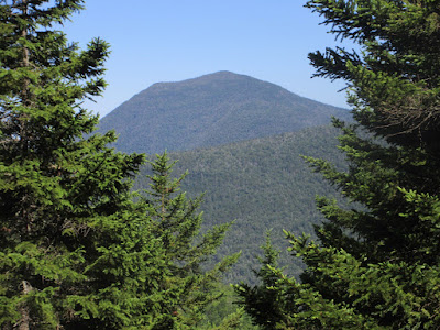
All that remains here for views is a glimpse of Mt. Chocorua.
From here I made a steep-angled, prickly bushwhack across the slope to the one remaining open patch on the 1924 East Slide. I had visited this spot in 2008 and enjoyed a good view, and hoped the vista had not been obscured by a decade of tree growth.
This view from Mt. Passaconaway taken this March showed that there was still a small opening, seen below the North/Middle Tripyramid col. (Also, note the top of the 2011/Irene slide on West Sleeper to the left.)
Revegetation is nearly complete on the 1924 slide.
But there is still a fine view here. Earlier AMC Guides touted the "wild and interesting views towards Passaconaway and Chocorua" from the East Slides.
A nice open look at Chocorua.
There is a particularly fine profile of Passaconaway.
A wild northern spur of Mt. Whiteface with a prominent white ledge. (A great and unusual viewpoint, but thick to get to.)
I decided to follow the track of the older slide - the longtime route of the Sabbaday Brook Trail - back down to the brook. I had descended this with a friend in 1980 when it was still somewhat open, with gravelly and loose rock footing. Not much of that left anymore. In those days the climb from the brook to the ridgecrest was a very steep 1000 ft., as arduous a climb as the North or South Slide.
A framed vista of Passaconaway lower down.
In its lower reaches the old slide track is completely in the woods.
I made a few detours around blowdown-choked spots through fine spruce woods.
A beautiful spot on Sabbaday Brook at the base of the old slide. It would be very difficult to find the track from the bottom.
Delightful walking back down the valley.
On the way out I made a short, steep bushwhack to an open patch on a slide that fell off the Fool Killer many years ago.
The perspective here is looking up at the lofty ridges surrounding the upper valley. West Sleeper is seen behind a ridge descending steeply off Tripyramid.
The top of Middle Tripyramid just peeks over the ridge.
Late afternoon light in a pretty glade. It was a good day to be immersed in this cool, scenic valley.


Steve, I've enjoyed this post (among countless others), as it brings to mind my late father's stories of staying at the Swift River Inn. He and my grandfather made the climb to the Tripyramid summits by the route you reference, probably in the 1935-37 timeframe. About 2000, my dad and I may have found the site of the Inn at your indication, perhaps at the Passaconaway WMNF campground?
ReplyDeleteWill Scott
Thanks for sharing your memories, Will! That's neat to have a family connection to that beautiful area. I'm not sure of the exact location of the Inn, but it was certainly in the neighborhood of the campground. -- Steve
DeleteThank you for writing this up Steve. I really must stop in and meet you some time. I hiked the Sabbaday Brook trail a couple years ago and the trail was rather elusive and the approproate location of r the stream crossings closer to the highway were unclear. I had heard that the forest service was planning to reroute to make it simpler with fewer crossings. Is the lower end of the trail better marked and such these days? Your write up makes me want to go back. When I was coming back off the Tripyramids that way I was cold and scraped up from the ice above and didn't really notice much of the surroundings. I am fascinated by the logging history so I'll have to go back and explore.
ReplyDeleteThanks, David. The trail can be indeed hard to follow at some of the brook crossings. Some of the crossing are "creative." It's still confusing on a section right above the falls where the trail used to cross a dry brookbed that now has major flow in it. The best route now tightropes along the bank there. The planned reroute to avoid crossings never happened. It is an interesting and beautiful valley! -- Steve
Delete