
WHITE MOUNTAIN CROPWALK XXVI - FLAT MOUNTAIN POND: 10/13/14
On a sunny fall morning, five of us gathered at the eastern trailhead for the Flat Mountain Pond Trail in Whiteface Intervale for the 25th annual White Mountain Cropwalk, a "hike for hunger" that benefits the programs of Church World Service. This year's participants included Thom Davis, Mike Dickerman, Roger Doucette, Gary Tompkins and this correspondent. Roger joined us after having completed an Appalachian Trail thru-hike with his son Jim on September 19!
Since its inception in 1989 our walk has raised more than $65,000 for the anti-hunger programs of Church World Service, with more than $16,000 of that provided to local pantries in the western White Mountains. Every year some 1,600 CROP Walks are held across the U.S. Ours is the only one in which walkers hike on mountain trails. We owe the success of our walk to the consistent generosity of our sponsors. The CROP Walk theme is “Ending hunger, one step at a time.” To make a donation for our walk, visit http://hunger.cwsglobal.org/site/TR?fr_id=19834&pg=entry
The first White Mountain Cropwalk in 1989 was just me and Mike Dickerman on a 21-mile Twins-Bonds traverse. Over the years we've had some great Cropwalk hikes, including traverses of the Pemi Wilderness (several), Dry River valley, Franconia Range, Shelburne Moriah/Wild River, Squam Range, Appalachian Trail in western New Hampshire, Mt. Moosilauke, Three Ponds area, and Mts. Passaconaway and Whiteface. In the photo below, three of this year's walkers - Mike, Roger and Thom - take in the view from a ledge on the way up the McCrillis Trail to Mt. Whiteface on our 2005 Cropwalk.

Just a few minutes into this year's hike, we enjoyed a colorful view of the southern Flat Mountain across an open bog.

Sandwich Dome in the distance.

A sign marks the turn off an old logging road.

About a mile in there's a nice view of Mt. Whiteface from a high bank above the Whiteface River.

After crossing Whiteface River, the Flat Mountain Pond Trail enters the Sandwich Range Wilderness, and heads up the valley, soon crossing the river's East Branch.
The Whiteface River is jammed with huge boulders; this one has an interesting shape.

Looking back down the river.

This was a delightful upstream walk in the morning sun., with several spots to enjoy views of the river.

Taking a break deep in the valley.

A gorgeous morning for a hike!

Mike crosses the Whiteface River at the three-mile mark.

Lots o' hobblebush.

Colorful forest approaching the pond.

The sprawl of Sandwich Dome seen from the north end of Flat Mountain Pond.

Someone propped this wrench up near the pond - a relic from the Beebe River Logging Railroad (1917-1942), which ran along the west shore of the pond and wrapped around the north end. We always remind readers that it is illegal to remove historic artifacts such as this from the White Mountain National Forest. Plus, it deprives other hikers of the opportunity to see these pieces of history.

From the NW corner of the pond, a spur line of the logging railroad leads a short distance to a pretty beaver pond with a view north towards the remote and mysterious Lost Pass, which is flanked by the northern of the two Flat Mountains on the left and a western spur of East Sleeper on the right.

The northern Flat Mountain.

Time for a lunch break.

Then we headed north up the railroad spur line to the site of Camp 11, where many crosscut saw blades were strewn across the area.

The door from an old wood stove.

Pancakes, anyone?

There are many bed frames around the camp site.

Gary thought this large rusting piece might have been a cooler or freezer.

Cover of an old barrel.

Blue spoon stuck in the ground.

The brook that flows down from Lost Pass.

The find of the day - a standing and still operable harp signal switch near the end of the spur line.

A great piece of logging railroad history.


A piece of rail left along the spur line.

A pool and small cascade along "Lost Pass Brook."

This birch tree grew up through a bed frame.

A sled runner - a relic found at many old logging camps around the Whites.

Thom heading back along the spur line. The birches in this area grew in after a 1923 forest fire that burned 3500 acres and shut down the logging operations up at this end of the railroad.
Another look at Lost Pass.

Back on the Flat Mountain Pond Trail, Thom takes in the view along the west shore of the northern part of Flat Mountain Pond.

A profile of Mt. Whiteface.

Whenever I traverse the shore of the pond, I take a few minutes to scramble up this tall trailside boulder for the view.

Boulder-top view, looking south down the pond.

Mt. Whiteface behind its trailless West Spur.


From a side path down to the shore, a view of the wild area between Mt. Whiteface and East Sleeper.

The southern Flat Mountain seen across the pond.

View of the northern Flat Mountain from the shore in front of the Flat Mountain Pond Shelter.

Group shot below the shelter. South Tripyramid in the distance, capped by a cloud.

The shelter, emptied out after what was probably a busy Columbus Day weekend.

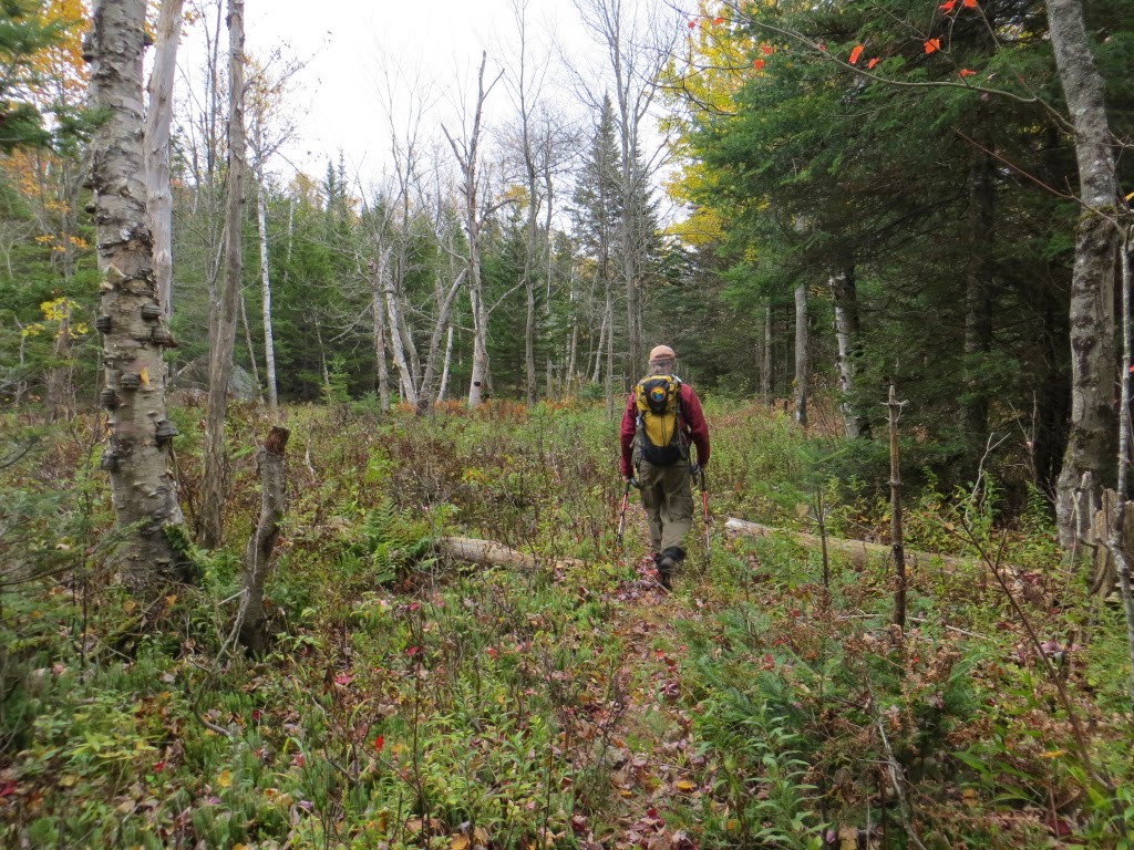
Mike on the long railroad grade section along the western half of Flat Mountain Pond Trail.

Beaver meadow by the famous hairpin turn on the railroad.

Nice signage at the Flat Mountain Pond Trail/Bennett Street Trail junction.

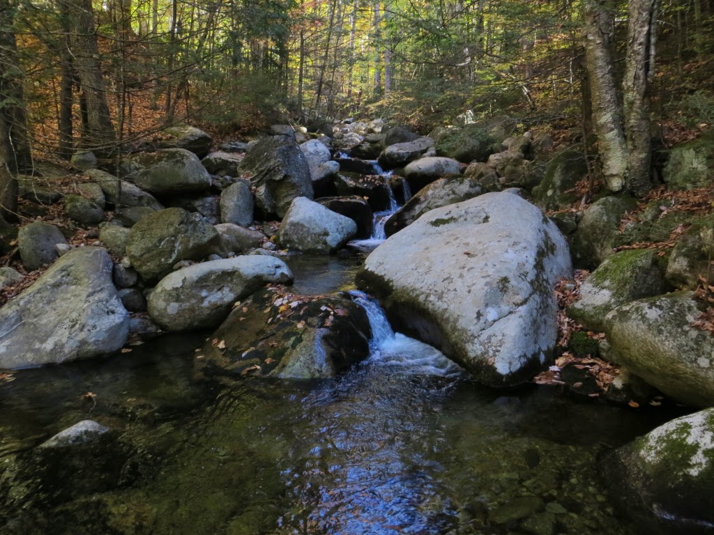
Great Falls on Pond Brook along Bennett Street Trail.

What looks like a recent bank washout along the brook. A tricky spot.

A nameless but lovely cascade, another great spot in the beautiful and varied Sandwich Range.


No comments:
Post a Comment