
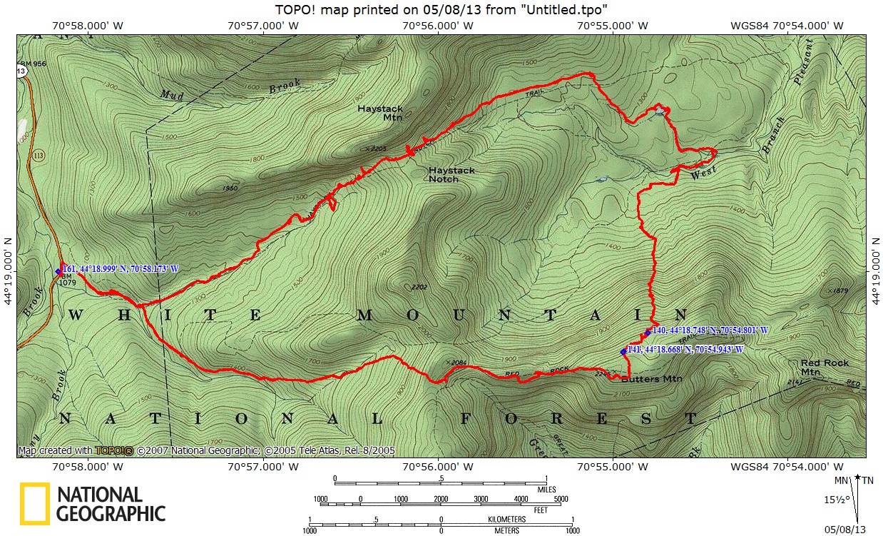
HAYSTACK NOTCH TO BUTTERS MOUNTAIN: 5/7/13
After gazing down into the Haystack Notch area and the valley of the West Branch of the Pleasant River last week from Caribou Mountain, I wanted to pay a return visit to that quiet and remote area in the Caribou-Speckled Mountain Wilderness. Early May is a great time to go there, as the vast hardwood forest begins to swell with wildflowers and fresh greens.
For this exploration I teamed up with my bushwhacking buddy John "1HappyHiker" Compton, who had never been on the Haystack Notch Trail. Our plan was to meander through Haystack Notch, where there is a "rich woods" hardwood forest with lots of wildflowers, then descend into the West Branch valley and bushwhack to several beaver meadows. John would then head back from the meadows as he had an evening commitment. If time and energy permitted, I would continue on and possibly bushwhack up over Butters Mountain on the Red Rock Ridge for some views.
John and I rendezvoused mid-morning on Rt. 113 in Evans Notch, where there is room for a couple of cars to park near the start of the Haystack Notch Trail. The first mile of the trail featured lots of nice brook scenery, with five crossings of various branches of Evans Brook. With all the recent dry weather the crossings were easy today.

A scenic section of trail alongside one of the brooks.

At 1.3 mi. we entered the Wilderness and began ascending towards the height-of-land in Haystack Notch. With temperatures rising to 80 degrees today, the climbing was hot in the still-leafless hardwood forest.

A spring vignette - Indian Poke (False Hellebore) beside a small mossy brook.


These flowers were shaded by a large rock.

John, an excellent photographer, lines up the shot.

Climbing up into the Notch, we had some peeks up through the trees to the impressive cliffs on the south face of Haystack Mountain. Bushwhackers can find several good viewpoints up there, though the direct approach from the Notch is not recommended!

The prize wildflower in this area is Dutchman's Breeches, and we were lucky enough to find them at their apparent peak. We also found a few Blue Cohosh plants (another typical species of rich woods) but they were not yet in bloom.


The broad height-of-land in Haystack Notch, the gap between Haystack Mountain on the north and a spur ridge of Red Rock Ridge on the south. The Haystack Notch Trail is very lightly used and sparsely marked, and was a bit hard to follow through here and in other places.


John found a luxuriant carpet of Dutchman's Breeches below an old maple, just off the trail to the north.

Beautiful hardwoods as we begin to descend eastward into the West Branch valley.

A big old yellow birch beside the trail. According to Forest Service planning maps, some of the trees in this area are up to 125-150 years old.

A nice patch of Indian Poke along one of the West Branch headwaters.

We continued down the broad, gentle valley to the eastern Wilderness boundary, then bushwhacked south through hobblebushy woods to a beaver meadow in the center of the basin. From the north edge we could see the long ridge of Butters Mountain, where I hoped to climb later in the day.

From the east edge of the meadow, we could see the spur ridge on the south side of Haystack Notch.

A small pool of water remains from this former beaver pond.

From the SE corner, a peek at the three summit humps of Haystack Mountain.

John takes in the view of Caribou Mountain. The only downside of visiting the meadow was that we each picked up several unwanted passengers in the form of wood ticks.

A zoom on the eastern ledges of Caribou, where I was lounging a few days earlier.

From the meadow we followed a meandering outlet brook to the SE.

This led us to an abandoned beaver pond, which was brimming with water when I visited back in 2000.

The east end of Butters Mountain rises above the old pond.

On the south side of the pond we came to the series of meadows along the West Branch of the Pleasant River. This idyllic area always reminds me of Pink Floyd's pastoral masterpiece, "Grantchester Meadows."

John captures the scene. For John's excellent report and photos on his "2 Small 2B Big" blog, click here.

We found Coltsfoot blooming on the riverbank.

From the next open spot upstream, John headed north back to the trail so he could be home in time for his evening commitment. I relaxed for a while in the hot sun on a stony beach.

Then I continued upstream to the west through more meadowy areas.

Deer tracks in the mud. There were moose prints, too.

A washed-out bank at a curve in the river.

The westernmost in the series of meadows. A wonderful area to explore on a sunny spring day.

Old beaver cuttings.

Looking back at the western meadow. Though the meadows are just outside the Wilderness boundary, they are within a "Roadless Area" and the woods around them are currently protected from road-building and logging. Hopefully this beautiful backcountry area will remain undisturbed.

A little after 3:00 I bid adieu to the West Branch and headed south up the slope towards Butters Mountain, following this mossy little stream for a while.

The 1000-ft. climb was steady and straightforward through hardwood forest, with some fairly steep stretches.

I was ascending a minor ridgecrest, with another ridge visible off to the east.

Fine old hardwoods up at about 1950 ft.

I reached the top of the Butters Mountain ridge a little east of where I had planned, and was surprised and delighted to stumble upon this unusual ridgecrest bog-meadow.

From an open scrubby area nearby there was a fine view north to Caribou Mountain, with Haystack Mountain to its left.

This was a neat area of scrubby, stunted hardwoods, reminding me of some Catskill ridgecrests.

An old snowdrift and aged birches.

Most of the long, flat top of Butters Mountain (2246 ft.) is cloaked in a dense spruce forest. I angled across through these woods to a favorite north-facing ledgy patch which offers excellent views. To the NW you can see the Moriahs and the distant Pilot Range beyond Haystack Notch.

A backlit early evening view westward to Carter Dome/Mt. Hight, Mt. Washington, the Royces, North Carter and Mt. Adams.


The eastern Mahoosucs seen through Tyler Notch, with ledge-spotted Tyler Mountain on the right. The dark outline of the first beaver meadow we visited is seen in the lower center.

At 5:45, after a wonderful 45-minute rest on the ledges in the evening sun, it was time to head for home. First up was the dense 0.1 mi. whack south to the Red Rock Trail across the flat top of Butters.

Then I walked a mile westward on the wild, little-used Red Rock Trail. Partway along there was a glimpse ahead to Durgin and Speckled Mountains.

There are some remarkably gnarled trees on this ridge, I dubbed this one the "witch tree."

An opening just off the trail granted an evening view south over the Great Brook valley to Kezar Lake and Pleasant Mountain. As my bushwhacking friend J.R. Stockwell once said late in the day on a long off-trail trek, "The shadows are gettin' kinda long."

The Red Rock Trail was very hard to follow in the leaf-covered floor of the open hardwoods. At one point I guessed wrong on a choice of two potential routes and had to bushwhack back up to the trail. I saw some recent footprints in a solid old snowdrift and later learned that hiker Scott L. was redlining up here in the late afternoon; we must have just missed each other.

When I reached the junction with the Great Brook Trail, it was time to begin the final bushwhack leg of the journey, a descent into the valley of the south fork of the east branch of Evans Brook.

I made a short climb over the ridgecrest...

...and began the descent, at first through hobblebush-infested birches.

Farther down the hardwoods were nice and open and the bushwhacking was mostly pleasant. The final stretch followed an old, often mucky logging road back to the trail, a half-mile from the trailhead. (I had used this same road back in 2000 on a descent from the Durgin-Speckled col, and on it I found the best moose antler I've ever come across - weighing 15 pounds with 13 points and in pristine condition. I keep it under the table at the store.) I made it back to my car just before dark, concluding a memorable day in the Caribou-Speckled country.


Steve, as you know, exploring things that are new to me is one of my passions. And since I'd never hiked the Haystack Notch Trail, this was a terrific experience for me. Sorry I was unable to join you for the second half of this exploration. Your photos and narrative provide an excellent virtual experience of what I missed. However, there's no substitute for being there and experiencing it firsthand.
ReplyDeleteAs always, you did a first class job with your write-up. The hiking community is blessed to have someone like you who is an intrepid explorer, and a gifted writer.
John
Thank you for your kind words, John. I'm glad you were able to join me for a good part of the day. You got some very fine photos on your blog (I added a link) to capture the flowers and scenes. That's a wonderful "back of beyond" area out there.
DeleteSteve
Love this post. I used to hike Butters a lot about 15 years ago, when I lived in West Bethel. I appreciated the view of Kezar, as I remember sitting on the ledges many an afternoon, looking at the lake. It was such an unpopulated hike that it was a favorite. My idea of an excellent hike is seeing no other human other than those I may be with. I am impressed by your knowledge of all of the surrounding mountains, the wildflowers and the direction in which you are looking. Very detailed, interesting and informative post. Thank you for sharing, and thank you for sharing your friend's link, as I love to read about what others are hiking and seeing. I am getting out tomorrow (a wellness day from work) and am looking forward to it. Thanks again.
ReplyDeleteThank you for your comment! The Butters-Redrock-Speckled-Caribou area is wonderful, one of my favorite places in the Whites. Hope you have a good hike on Wednesday!
ReplyDeleteSteve