
LOON MOUNTAIN EXPLORATION: 8/21/12
With a half-day off under partly sunny skies, I decided on an exploration close to home: Loon Mountain. I had wandered around this interesting mountain, best known for its major ski area, several times before, but it had been a number of years since I paid a visit. I rode the gondola up to a sub-summit, with plans to seek out an old hiking trail to the North Peak, then descend via ski trails with off-trail side trips to Loon Pond and Little Loon Pond.
From the top of the gondola, I walked down a path to the outdoor amphitheater with its spectacular view, where Carol and I were married in 2000. Where else can you tie the knot with the Bonds as a backdrop?

I took a quick walk down and up through Loon's glacial caves, sort of like a little mountaintop King Ravine Subway, if you go off the main route.


I dropped off the back side of the gondola summit on a ski trail, then climbed up another ski trail a ways and bushwhacked across to pick up the abandoned hiking trail that climbs steeply to the ledgy true summit (3065 ft.) of Loon Mountain. Most of the trail was pretty clear and easy to follow, and there were still some old orange blazes.

The old trail is pretty steep in places, including this ledgy slot.

The upper 0.1 mile was in rough shape, overgrown with lots of blowdown.

I hadn't been up here in a few years, and the view from the summit ledges has grown up considerably, though it's still pretty decent. This vista looks over nearby Black Mountain and across the Pemigewasset Wilderness to the Willey Range and Mts. Hitchcock and Hancock; the distant Presidentials were socked in.

By standing, I could see over the trees to the Twin-Bond Range. I could spot two new slides from Tropical Storm Irene - a good-sized one on the side of Mt. Bond, and a small one in the Redrock Brook basin.

Scar Ridge looms ominously to the east, beyond the North Peak ski trails.

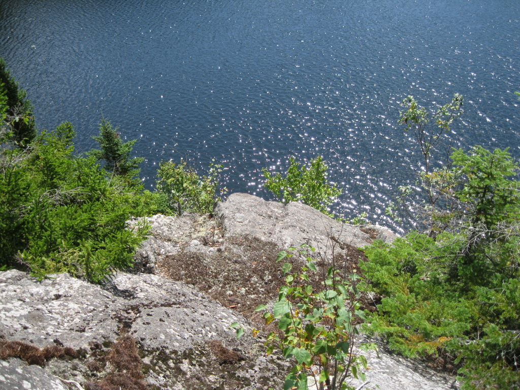
I followed the old hiking trail back down to its beginning on a ski trail, then descended along another ski trail towards Loon Pond. I made a short bushwhack to the top of an open cliff that drops into the water of this beautiful glacial pond, which was at one time far better known than it is today. The original name for Loon Mountain was Loon Pond Mountain, and a hundred years ago the pond was famous as a natural beauty spot. A crude trail led to the pond, and visitors then sometimes bushwhacked to the South Peak or North Peak of Loon for views. In 1881 intrepid AMC explorer Lucia Pychowska wrote an interesting article for Appalachia about an exploration of Loon Pond Mountain and its two ponds. In this photo, taken from the clifftop, Loon's South Peak rises beyond the pond.

Looking down at a corner of the pond. In recent years Loon Pond has been better known as a source of snowmaking water for the ski area (it's no longer used for this purpose) and as one source of drinking water for the town of Lincoln (no camping, and visitors should take care to protect the purity of the pond).

The cliffs drop right down into the water.
Someone had set up a convenient bench for viewing the pond. What a peaceful and relaxing spot, close to the ski area but feeling far removed.

I returned to the ski trail and descended some more, then made another short bushwhack to the cliffs that overlook Little Loon Pond, which Lucia Pychwoska referred to as "a rock-set gem."

Looking across at the South Peak of Loon.

Relaxin' on the ledges.

Little Loon, small and secluded. Until the 1960s both Little Loon Pond and Loon Pond could be accessed by the WMNF Loon Pond Trail, which ascended along the west side of both ponds.

A ledgy spot near the Little Loon Pond cliffs opens a view NW to the Kinsman-Cannon ridgeline.

A peek from the ledge at Big Coolidge, Liberty and Flume.

I found an old herd path leading back to the ski trail.

Walking down the ski trails through carpets of late summer wildflowers, with a great view ahead of the peaks surrounding the slide-scarred Clear Brook basin.

A zoom on Clear Brook, with Mt. Flume in back and Whaleback Mtn. on the R.

Mt. Bond in the distance, with the new Irene slide visible. East Whaleback (once called Elephant Mtn.) and Potash Knob in front on the L.

Around a bend, a view of Moosilauke. I took a variety of ski trails back to the base of the mountain, concluding an interesting half-day on Loon.


Wow Steve. That is a great report. Loon is perhaps my favorite place in the WMNF. Primarily for the skiing and it spectacular views. I've hiked it several times but more for exercise and never as extensively as that. Never visited the pond. And I didn't know there was an old trail to the true summit. Just wonder photos.
ReplyDeleteThanks for sharing,
Joe
Thanks, Joe - it's great having a place like this in our backyard.
ReplyDeleteSteve
Steve, as Ellen Ruggles said in her comments on Facebook about your trek:
ReplyDelete"You take us to the coolest places with your photos. Thank you."
Your narrative descriptions (and your links) make for such an interesting read! And, as always, the photos that you include are a splendid enhancement to your text. Speaking of photos, I was particularly taken with the one where you were walking down the ski trails through carpets of late summer wildflowers, with the view of the peaks surrounding Clear Brook basin.
Although hiking on Loon is something that I've often considered, I have as yet to do it! Your report has certainly renewed my interest in doing so. I'll have to drop by sometime and get some pointers from you about this. Don't know if I'll get to it this year before the winter season begins, but if not, then it will be high on the list for next summer season!
John
Thanks for your kind words, John. That ski trail with the wildflowers and views was a real treat. Loon is an interesting mountain that had some popularity with hikers long before it became known for skiing. If Loon Pond were in the backcountry with a hiking trail, it would be a major draw for hikers.
DeleteSteve
I love your trip reports Steve. Sitting here in my cube your words and pictures make me long to get back up there.
ReplyDeleteBill
Thanks, Bill - glad the blog brings some enjoyment to your workday.
DeleteSteve
Hi Steve,
ReplyDeleteI had no clue there was so much on this mountain. I have a strange prejudice against ski mountains because they are not all that pleasant to look at in the summer time with the slopes torn up. However, you've kind of given me a new perspective. The Ponds you highlight are unbelievable, and on the map, look like there at pretty hefty elevation for their size. Do you know of any old trail maps in existence that have the abandoned trails you mention on them? Great report. Thanks for giving me a new perspective of Loon Mountain.
Karl
Thanks, Karl. Ski areas are a different kind of hiking experience, but they offer lots of views, and in Loon's case, the two beautiful ponds. The old Loon Pond Trail is shown on the AMC Franconia Region trail map from the 1950s. Loon Pond is at an elevation of 2418 ft. and Little Loon is at 2220 ft., definitely respectable elevations.
DeleteSteve