
I set out late morning for a seven-mile loop over two of the higher peaks in Acadia - Sargent Mountain (1379 ft.) and Penobscot Mountain (1196 ft.). Both of these have wide-open summits and long, bare ridges running north and south. The plan was to go up the south ridge of Sargent and down the south ridge of Penobscot (also known as Jordan Ridge).
I parked at the Jordan Pond House trailhead off the Park Loop Road and started with an easy two-mile traverse on the Asticou & Jordan Pond Path, which runs SW to the lower end of the Sargent South Ridge Trail.
 This route was a very enjoyable woods walk with good footing, mostly through a fine spruce forest that escaped the great 1947 Mount Desert Island fire.
 A little more than halfway along, the trail crossed Little Harbor Brook on a nifty footbridge.
 Stone steps, typical of many Acadia trails, led up the side of a low ridge beyond the brook.
 Shortly up from its beginning, the Sargent South Ridge Trail crossed a carriage road.
 The trail made a long, gentle climb up the ridge, through spruce woods and across semi-open ledges.
 Could be good blueberry-pickin' here in August.
 A weathered old spruce tree.
 About a mile up the ridge I broke out onto open ledges with views out to the Atlantic, and down into the valley between the Sargent and Penobscot south ridges, known as The Amphitheater.
 Ledgy Penobscot Mountain rose across the head of The Amphitheater.
 I made the short side trip to the open top of Cedar Swamp Mountain (942 ft.), the high point of the lower south ridge of Sargent.
 Close by to the NW was the rocky knob of Bald Peak, another Sargent satellite.
 From Cedar Swamp there was a short, steep drop into a shady col, where a large snow patch lingered.
 In this sharp cut was Birch Spring, whose outlet stream flows down into The Amphitheater.
 Near this junction there was a pack on the ground, the closest I came to encountering another hiker on this solo full-day trek.
From the little notch the Sargent South Ridge Trail quickly climbed back out onto open ledges.
 From the crags seen in the previous photo, there was a great vista back down the ridge I had ascended thus far.
 This was a great spot to relax and gaze down into The Amphitheater.
 After traversing a belt of scrub, the trail was completely in the open on the upper south ridge of Sargent.
 To the L, views opened to the mountains in the western part of the park.
 The archway-style cairns typical of Acadia led the way up the broad, gentle ridge.
 The summit of Sargent was marked with a large pile of rocks, a summit sign, and multiple trail signs. Trails lead here from all four points of the compass.
 I dropped a short way down the East Cliffs Trail for some grand views in that direction. Eagle Lake sprawls to the NE, with Frenchman Bay beyond.
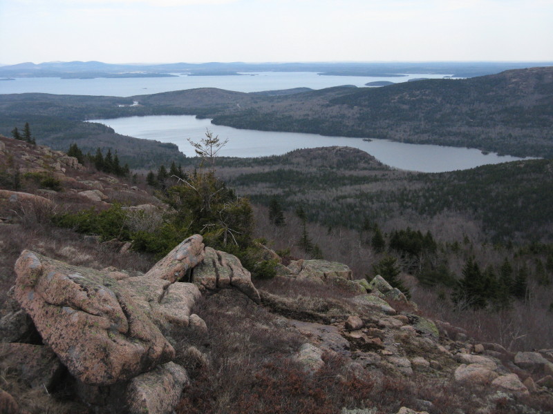 Cadillac Mountain rises above the cliff faces of North Bubble.
 An hour flew by on this fine summit. Time to head back down the ridge, with ocean views ahead.
 Penobscot Mountain, the next objective.
 I turned L on a connecting trail and dropped to Sargent Mountain Pond, a beautiful tarn resting at an elevation of nearly 1100 ft. It was still two-thirds frozen.
 A steep dip into a notch and a quick scramble up the other side got me to the summit of Penobscot, where I could look back at Sargent Mountain.
 To the west was an array of ledgy ridges.
 The north view from Penobscot.
 Heading down the Penobscot Mountain Trail along Jordan Ridge, I soon came to a magnificent vista over Jordan Pond to Pemetic Mountain.
 The Jordan Pond House and my car were down there at the south end of the pond.
 South Bubble and Cadillac from a different angle.
 Walking into the ocean views again. Acadia is a place of vast horizons.
 Looking across to the cliffs on the west side of The Amphitheater, atop which I had stood in the morning.
 A nicely perched glacial erratic.
 A mile down from the summit of Penobscot, I turned L on the innocently-named Spring Trail. A flat ledge offered one last view over Jordan Pond. Just a half-mile to go to the trailhead.
 But what a half-mile! I had descended this route in 1991 with friends Mike and Harry, but didn't remember how precipitous it was, working down through crazy cliff terrain. Here an amazing rock staircase leads down through a narrow cleft.
 Yikes! There were some dropoffs on this trail.
 A memorable walkway along the edge of a cliff face.
 Not sure I would be comfortable on this route without the railing, especially if it was wet.
 Looking back up.
 One last steep pitch with help from some iron rungs. You can see a carriage road down the precipitous slope on the L. It was a bit of a surprise to encounter this at the end of the day. Good training for the several "Ladder" rated trails in the park, the most famous of which is the Precipice Trail. All in all, a memorable day on the trails of Acadia, and I'm quickly becoming hooked on this place.

Very nice Steve. These are a couple I've yet to do. I hope to make there this summer. A hikers paradise for sure.
ReplyDeleteThanks for sharing,
Joe
Thanks, Joe. Don't why I waited 20 years to pay a second visit. What a great place. Hope you can get up there this year.
ReplyDeleteSteve
Ohhh! That looks like a magnificent hike!!
ReplyDeleteIt must be quite an experience when you catch the first sight of the ocean after emerging from the forest.
Your photos are remarkable. I especially like those that show land and sea stretching out as far as eyes (and binoculars) can see.
John
Welcome back, John! Yup, at Acadia, as the saying goes, on a clear day you can see forever. And on some trails there's plenty of scrambling to add a little extra spice.
ReplyDeleteSteve
Well done Steve! I've wanted to hike Acadia for years, Michele was always of the attitude of take it or leave it when it came to Acadia. Now that she has seen your pics, she wants to go next year!
ReplyDeleteHi Scott,
ReplyDeleteI had a little bit of the take it or leave it attitude also, which is why it took 20 years to get back there. The first short hike cured that! Hope to get a couple more Acadia posts up during the next few days.
Steve