
Off to Acadia National Park for spring vacation! My one previous visit to this hiker's paradise was twenty years ago, and Carol's last visit here was over twenty-five years ago. After the 260-mile drive from Lincoln, we checked into our Bar Harbor hotel late afternoon. That left a few hours of daylight for a quick jaunt to the Bubbles area. One of the beauties of Acadia is that the trailheads are close to town, and on some trails you can reach magnificent views in 15 or 20 minutes of hiking.
I parked at the Bubble Rock trailhead on the Park Loop Road and set off on the Bubbles Divide Trail about quarter to five.

The trail started off in hardwoods on blessedly snow-free ground.
 After a short climb I turned R towards the North Bubble, the higher of two small ledgy, rounded peaks that rise prominently above the north end of Jordan Pond.
 Within a few minutes I gained the first of countless views enjoyed during our Acadia trip, looking east towards Cadillac Mountain, at 1530 ft. the highest peak in the park, and indeed the highest point along the U.S. Atlantic coast.
 As with many Acadia trails, there were a few short ledgy scrambles.
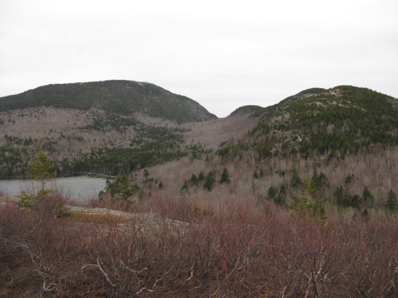
 At one spot there was a close-up view of some of the numerous cliffs on North Bubble.
 Looking across Jordan Pond to the Jordan Cliffs on Penobscot Mtn.
 The open summit of North Bubble, with Pemetic Mtn. rising behind. Most of the Acadia summits have similar signs at or near the high point.
A classic Acadia vista - looking down Jordan Pond to the Cranberry Islands and the great Atlantic.
 While driving along the Loop Road to the trailhead, I had seen the barren northern ridge of North Bubble. It looked so inviting I changed my original plan of doing a loop over both Bubbles to exploring northward along this ridge. The trail ducked briefly into the woods.
 After a dip into a saddle, where a few snow patches lingered, the trail broke out onto open ledges looking across the valley to Cadillac.
 I could also look back at the steep western flank of Pemetic.
 To the north was the 436-acre expanse of Eagle Lake, the largest freshwater body wholly within the park. Ahead, the ledgy knob known as Conners Nubble looked too inviting to pass up.
 A wider view of Eagle Lake.
 The view over the lower country to the NW, including Aunt Betty Pond and McFarland Mtn.
Some of the Acadia ledges are populated with pitch pines, a tree I associate with the sandy soil of Cape Cod.
 Continuing north, the Bubbles Trail descended into a broad hardwood saddle.
 Here it crossed one of Acadia's gorgeously smooth carriage roads. Unfortunately for us, the annual closure of the carriage roads for mud season came late this year, so we were not able to enjoy them this week.
 A short, ledgy scramble led up the side of Conners Nubble.
Another open summit with great views. This one had a nice remote feeling, out along the SW shore of Eagle Lake.
 Phenomenal views for a 580-footer. To the SW was the ledgy mass of Sargent Mtn., second-highest peak in the park.
Looking south to the Bubbles (R) and Pemetic Mtn. (L).
 An expansive look at Eagle Lake.
 It was late in the evening, and I had to hustle back along the Eagle Lake Trail and Jordan Pond Carry Trail. I paused briefly for some views at the south end of Eagle Lake, here looking across at Cadillac Mtn.
 Around the corner there was a look back at Conners Nubble.
 A parting shot looking north up the lake, then it was time to head for the car, completing a brief but very rewarding re-introduction to the pleasures of Acadia.

Steve - great report, as usual. Our family has been to Acadia twice in the past four years and we love it. So many different types of beautiful hikes. We hiked Conners Nubble on on a crystal clear July 4 a few years ago and picked fresh blueberries while watching a bald eagle circle overhead. Fantastic.
ReplyDeleteThanks, BC - Conners Nubble immediately became one of my favorite spots up there. Can't wait to go back.
ReplyDeleteSteve