
This week I had a hankering to wander out into the western Pemi Wilderness, using our "backyard" trailhead at Lincoln Woods. Normally Carol, "my favorite snowshoer," would have joined me for this outing during her school vacation week as she, too, enjoys long rambles in the Pemi. Unfortunately, her left knee has been painful since last September - the tipping point apparently was a descent of the ladders on the Osseo Trail - and last Friday she had arthroscopic knee surgery and a microfracture procedure. She is recovering well and is in good spirits - a real trooper - but she may be on crutches for several more weeks. Though she was unable to join me on this trek in person, she was there in spirit throughout the day.
I started off from the Lincoln Woods trailhead at about 10:20 am on a gorgeous cold, sunny morning. There were very few people around and the ranger cabin was closed. It promised to be a quiet day out in the Pemi.

I put my snowshoes on as soon as I got across the suspension bridge. Even the ultra-popular Lincoln Woods Trail was only softly-packed after a foot of snowfall last weekend into Monday. For the most part, folks had been heeding the lane designations for skiers and snowshoers/hikers.
 The morning sun was pouring across the wide trail. The old hemlock ties left over from the J.E. Henry Company's logging railroad were all covered up by the snowpack.
 By the Osseo Trail junction I made a short side trip on an old roadbed to a high bank along the East Branch with a partial view north to Owl's Head out in the heart of the Pemi. I was looking forward to getting some close-up views of this iconic wilderness mountain from the beaver ponds along the Franconia Brook Trail.
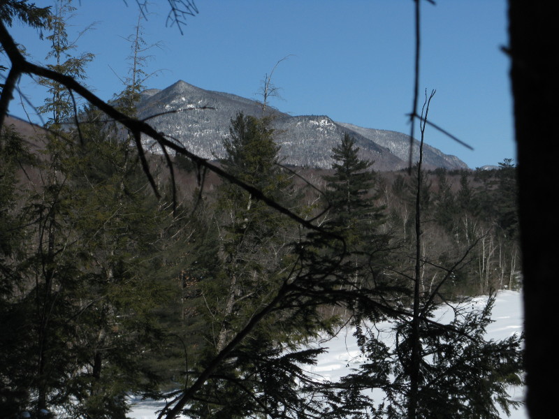
Across the snow-blanketed river I could see three of the five peaks of Mt. Hitchcock.
 Back on the main trail, the brushy clearing of J.E. Henry's logging Camp #8 was slumbering under a deep mantel of snow.
 A little farther along, where the trail brushes by the riverbank, I made a couple of forays down to the edge of the East Branch for views upstream to West Bond, with its five south-facing slides...
 ...and Bondcliff, flanked by its sharp southern spur peak.
 The snow became softer as I passed the Black Pond Trail (where the tracks of two barebooting hikers veered off, presumably heading for Owl's Head), and soon I reached the footbridge over Franconia Brook. No fresh tracks of any kind continued from here, only some older snowshoe tracks.
 From the bridge there's a long view up Franconia Brook to Mt. Flume.
 A closer look at Flume. The white patch is a talus slope on the mountain's NE ridge.
Across the bridge and into the Pemi.
 No one had been on either the Wilderness Trail (this section of which will soon become part of the Bondcliff Trail) or the Franconia Brook Trail in the last few days. There was a visible trough on both routes, so they were packed beneath the newer snow - a nice setup for some backcountry snowshoeing.
 The Franconia Brook Trail also follows an old railroad bed, though it is considerably narrower than the Lincoln Woods Trail. When we were winter peakbagging in the late 1980s, many groups went this way to Owl's Head, bushwhacking up the east side of the mountain from the vicinity of Hellgate Brook. This involved about 2200 ft. of bushwhack ascent, requiring a fairly large party for trail-breaking.
These days, most folks use the "Black Pond bushwhack," which cuts down on distance and avoids the two largest crossings on the Lincoln Brook Trail, and, increasingly, the "Brutus bushwhack" route, which avoids the potentially dangerous Owl's Head slide. (This route was pioneered a few years ago by Kevin Rooney & friends when Kevin's wonderful peakbagging Newfie, Brutus, wisely refused to ascend the slide.) As a result, the Franconia Brook Trail sees relatively little traffic in winter these days, at least from Owl's Head peakbaggers.
I settled into a slow, methodical pace, breaking trail through 8 inches of heavy, mealy snow. A few steps into the snow off the side of the trail dissuaded me of the notion of any extensive off-trail exploring today. The snow was too soft and deep for solo whacking of any distance.
 The first of three crossings of Camp 9 Brook, which was named after a nearby logging camp.
 Crossing #2 on the meandering brook.
 At 3.9 mi. from the trailhead, the Franconia Brook Trail makes a detour to the R to skirt an extensive beaver-flooded area. With deep snow and extended cold weather, this was an ideal time to explore this open area and enjoy the views of the surrounding mountains.
Along the bypass was a snow enclosure someone had built for a winter camping excursion.
 Near here I made my way out to the edge of the beaver swamp/pond for the first view of Owl's Head, including its sharp southern peak, its prominent SE cliffs, and the summit ridge stretching away to the north.
 For my money, this is one of the great sights in the Pemi Wilderness.
 A closer look at the SE cliffs. Lots of birch forest below, a result of the 1907 "Owl's Head fire."
 From another spot, the full extent of the pyramidal south peak could be seen, with Little Haystack Mtn. in the Franconia Range peeking out on the L.
 From a snag-filled beaver swamp on the other side of the trail, there was a view up to Bondcliff and its own sharp south spur.
 From the south edge of this opening, there was a glimpse of the very tip of West Bond (probably the westernmost knob on its summit ridge) peering over a 3314-ft. western spur of Bondcliff.
 Back at another spot along the extensive main beaver swamp, I found a view to Mt. Liberty and its NE ridge.
Despite it being deep winter, I chose my routes carefully around these snow-buried wetlands. I would not have tried to cross Camp 9 Brook at this particular spot, where the ice looked suspect. (After a rain/thaw event, it's not advisable to venture out from the edge of the wetland at all.)
 I followed a faint old snowshoe trough out to another opening, and proceeding a few yards to the L I was rewarded with a fine view of Mt. Flume, embraced by the spreading arms of two spur ridges. The ridge on the L holds the Osseo Trail; the sharp dropoff on the far L is the area of the ladders. Mt. Liberty is on the R.
 Mt. Flume and its curving NE ridge. The lower end of this ridge descends to a point just W of Black Pond. Not surprisingly, master bushwhacker J.R. Stockwell has ascended Flume via this ridge.
 I decided to continue another half-mile N to the next beaver pond along the Franconia Brook Trail. At the junction with the Lincoln Brook Trail, old snowshoe troughs were evident leading in both directions.
 The next beaver pond is about 100 yards N of the junction. I proceeded carefully out along its south edge, where there was a view NE to the southwestern ridge of South Twin Mtn. The nearer knob in the center is the Trailwrights list peak known as Southwest Twin (4357 ft.).
 Looking NW across the pond to the long ridge of Owl's Head, forming the west wall of the Franconia Brook valley.
 If anything, the south peak and SE cliffs of Owl's Head were even more imposing from this angle.
 Two winters ago, I joined fellow bushwhacking enthusiasts John "1HappyHiker" Compton and Chris "NeoAkela" Whiton for a memorable snowshoe ascent to the Owl's Head cliffs. Among the fine views we enjoyed was this perspective looking down on the beaver ponds, with Mts. Carrigain and Hancock beyond. The large swamp I first visited this day is on the far R. The beaver pond just N of the Franconia Brook/Lincoln Brook Trail junction is in the center. The two ponds on the lower L are on the west side of Franconia Brook; I didn't have time to visit them this day.
 After wandering across the beaver pond, I returned to the Franconia Brook Trail, which offers this view across its frozen expanse.
 The westernmost spur (2889 ft.) of Bondcliff rises just NE of the pond. Its upper slope is spotted with talus fields.
 Retracing my tracks - an off-trail crossing of Camp 9 Brook.
 On the way back down Lincoln Woods Trail, I made a short side trip to
the spot where Birch Island Brook issues into the East Branch. Here there is a fine view of Mt. Osceola - the main summit and Middle and West Peaks - looking down the East Branch. A nice way to cap off a leisurely day in the wilds of the western Pemi. Next time, I sure hope Carol can join me!


Steve . . . thanks for the memories! I'm referring to the trek that you, Chris and I made to the Owl's Head cliffs, which you reference in your report.
ReplyDeleteMemories aside, you certainly managed to get a lot of "bang" for your "hiking buck"! It all goes to show that one can stay in the lowlands and still have a terrific hike and experience some significant views to boot!
John
We hope Carol recovers real soon!
ReplyDeleteJohn & June
Thanks, J & J - she's doing really well so far!
ReplyDeleteSteve
Awesome Steve! Thanks for the unique views of Flume from a different angle. Truly gives a different aspect of the topography of the Osseo Trail.
ReplyDeleteThanks, Scott - that end of the ridge looks impossibly steep. You can see why the ladders were needed.
ReplyDeleteSteve
I'm hoping to hike that area this weekend, so I found your nice blog when Googling the Lincoln Woods trail. Gorgeous pics!
ReplyDelete