
The northwestern ridge of the Pilot Range has an aura of wildness not found in many other places in the Whites. This chain of wooded 3500-ft. peaks extends several miles NW from The Bulge, culminating in the 3730-ft. summit of Hutchins Mountain (also known as Mount Pilot), and then continues over several lesser knobs before descending to the valley of the Upper Ammonoosuc River. There are no maintained paths on this range, making it one of the larger blocks of trailless land within the WMNF.
The eastern side of the Pilots has an especially remote feeling. Other than a few fishermen and hunters working the lower elevations near the gravel Mill Brook Road, I suspect that these slopes see very few visitors in the course of a year. The "out there" feeling I experienced on a bushwhack I made in 1997, to a small talus slope viewpoint NE of Hutchins Mountain, has always stuck with me, even though the trek was only a couple of miles each way.
The photo below, taken from The Horn last November, shows the Pilots and their many eastern spur ridges flowing down into the Mill Brook valley. Hutchins is the prominent peak to the L of center.

A closer look at Hutchins reveals several rock outcrops that provide unusual views. When I first visited Hutchins in 1990 on a late fall traverse of four Pilot Range peaks with several friends, we did push out to one of these ledges to see the view. But daylight hours were short, so we could not linger. I have long wanted to pay another visit to the ledges on Hutchins, using one of the remote eastern ridges for an approach.

The Northeast was in the midst of an unusually late heat wave, with record high temperatures in many places, and even early in the morning one could tell that the humidity would be higher than forecast. John Compton and I rendezvoused at the end of the gravel WMNF Mill Brook Road (off Rt. 110 in Stark) and set off before 9 am. After walking down the road a couple hundred feet we struck into the woods. We would be off-trail from start to finish on this trek.
Our first objective was a beaver meadow at the base of the ridge we were to ascend. We should have stayed close to the brook that flowed down from there, but a fisherman's or moose path lured us a little too far to the south in a flat area and we ended up in some fairly rough spruce terrain right off the bat.

But before long the forest opened to friendlier hardwoods.....

...and we eventually made our way back to the brook, now tiny and mossy.

A mini-meadow gave us a preview of what lay ahead.

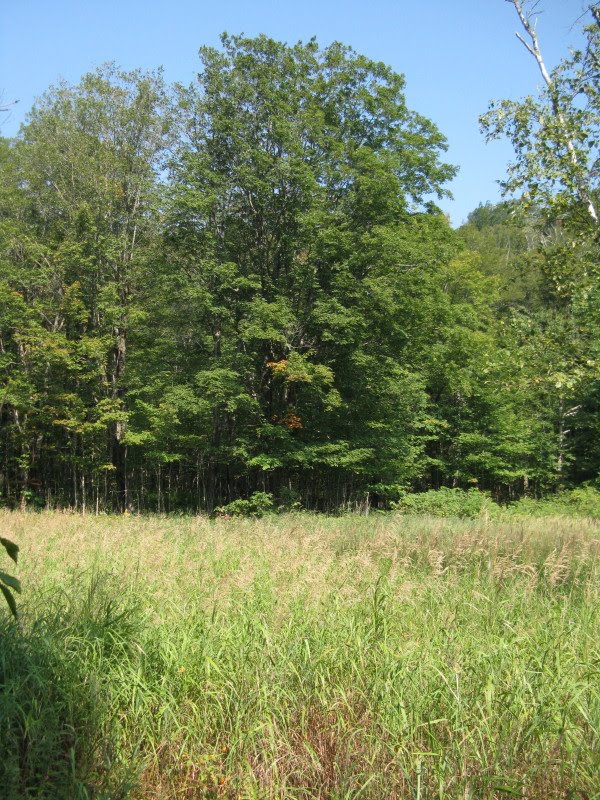
After an hour or so we found the beaver meadow, overlooked by a spur ridge of the Pilot Range.

What a peaceful, lovely spot, with chest-high, reed-like grasses (blue-joint grass, I believe) waving in the warm breeze. Two miniature brooks flowed into the meadow, which was mostly dry. Early settlers would sometimes harvest meadows like this for livestock forage, calling it "beaver hay."

Some large old sugar maples guarded the edge of the meadow. Located by an opening, these trees had a fuller, more spreading form than their tall, straight brethren back in the woods.
 We found this fern and fall hobblebush vignette behind the meadow.
After a nice break, we headed into the maple glade on the north side.

Looking back through the trees at the sunlit opening.
 We immediately attacked the rather steep-sided ridge that extends eastward from the main crest of the Pilots.
We soon stumbled upon what appeared to be the trace of an old tote road angling up across the steep slope. Moose had been using this passageway, and it provided us with an easier than expected way to gain elevation.


Eventually the old road petered out, so we whacked more directly up the slope through wonderfully open woods.

It doesn't get much better than this for off-trail travel.

 Of course, all good things must come to an end and somewhere around 3200 ft. or so we hit denser woods. On the flat shoulder SE of Hutchins they became very dense and strewn with old blowdowns, requiring some time-consuming weaving. After doing this for a while, we dropped down on the NE side of the crest and found better going.
The final climb up the cone of Hutchins was steep but we were able to stay in reasonably open woods.
 Near the high point we pushed through very dense scrub to a small N-facing outlook. Unfortunately the day was very hazy, so we could barely make out the Percy Peaks and Long Mountain beyond the northern ridges of the Pilots.
A zoomed look at the faint bare ledges of the Percys and the looming mass of Long. In the 1870s the summit of Hutchins was reportedly bare, and there was a signal station of the U.S. Coastal Survey here, which was accessed by a short-lived path.
 To the NE we could see Mill Mountain at the mouth of the Mill Brook valley, but not much else.
 Then we headed to the south side of the peak. After 20 minutes of probing down through very dense, flesh-ripping scrub, we found the area where the rock outcrops jutted out from the slope.
 The ledges provided marvelous views of the higher peaks of (R to L) Cabot, The Bulge and The Horn, seen over the two southerly Pilot Range neighbors of Hutchins (unofficially called West Pilot and Middle Pilot). Hutchins and Middle Pilot, as well as Mt. Mary (mostly hidden here) are on the New Hampshire Hundred Highest list. On the far L is Unknown Pond Ridge, also a NH 100 summit.
In August 1885, a group of AMC explorers including William H. Peek, Eugene B. Cook, George A. Sargent and Hubbard Hunt embarked on the first of three explorations in the then-largely unknown reaches of the Pilot Range. They first climbed to Hutchins (then called Pilot Mountain) over the bumpy ridge from the NW. They found the summit cleared, and Peek pronounced the view "bewitching" and "entrancing," especially "the splendid revelation of the Pilot Range itself." After taking in the vistas and making a sketch, they descended the steep south face of the cone and down into a ravine, where they camped. The next day they continued over more ridges and climbed Mt. Cabot, known then as the "Grand Pilot" or "Pilot Dome" -- perhaps a first ascent.
 A zoom on The Horn and The Bulge. With binoculars I could pick out the great granite ledge at the very tip of The Horn.
South Weeks, Mt. Waumbek and Mt. Starr King were hazily seen to the R of Cabot. On a clearer day we would have seen the Presidentials rising above the Waumbek-Starr King ridge, and farther R many western White Mountain peaks - the Willey Range, Carrigain, Hancock, Bond and the Twins, Garfield, Lafayette, Cannon, the Kinsmans and Moosilauke - would have been visible.
 A closer look at the several peaks of Unknown Pond Ridge.
 A ledge farther to the L opened views more to the east. First John battled his way over there to check it out.
 Then I followed suit, enjoying a hazy but unique view to the lower northern, cliff-faced peaks of The Kilkenny. Deer Ridge sprawls to the R towards Unknown Pond Ridge.
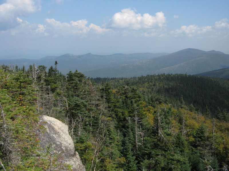 A lousy zoomed shot showing (L to R) Square Mountain, Green's Ledge and sharp-peaked Rogers Ledge.
 Looking back at John on our first view ledge.
 After a stay of over an hour on the ledges, it was time to start the three-mile whack back to the valley. Once off the summit cone, we kept a more northerly course and mostly avoided the dense blowdown area we had encountered on the way up. The woods soon opened up pretty well, in one place revealing a remarkable carpet of shining clubmoss.
Down around 3100 ft. we hit the really good woods.
 We spent a long time working across the NW side of our chosen ridge, and eventually hit the crest, where we passed by this great old yellow birch.
 And from a 2900-ft. shoulder down for a ways, the paper birch glades were glorious.


A flattened bed was one of the many signs of moose in this area.

Then we chanced upon an amazing moose path, as good as some maintained trails, leading right down the crest of the ridge.

This provided a pleasant respite from navigating our own route - the moose had laid it out for us!
 Eventually the moose path petered out, and we resumed normal whacking down through hardwood forest, ending up in this glade at the base of the ridge.
 We picked up and followed the brook that flows down from the beaver meadow we had visited on the way up. It occasionally opened out into small meadow-like openings.
 A look at the attractive brook, sprinkled with mossy rocks.
 Near the end of the long, flat runout, which had some of the thicker, slower woods of the day, we took a break where the West Branch of Mill Brook (on the R) joins the brook we had been following.
We made it out with plenty of daylight to spare. It was a memorable journey through some of the nicest wild country in the Whites.
On the way home I stopped by the Lancaster Fairgrounds to take a couple shots of the west side of the Pilots, with the prominent peak of Hutchins in the center.


To close this post, I am going to make a foray into National Forest policy - which I am somewhat reluctant to do on this blog - because I am passionate about the Kilkenny backcountry. The area we traveled through (along with a number of other prime backcountry areas in the WMNF) is currently spared from logging and road-building under the 2001 National Forest "Roadless Rule." (A Google search will reveal reams of articles on the long saga of the Roadless Rule. It should be noted that lands protected under the Roadless Rule are not designated Wilderness areas, and do not have the same level of restrictions.)
In 2006 the Forest Service proposed a major logging cut here at the lower elevations (up to about 2300 ft.), including the area right up to the beaver meadow, but this part of it was, thankfully, shelved when a court decision reinstated the Roadless Rule. The project would have markedly changed the character of this area, and not for the better. To my knowledge, the upper Mill Brook valley has been primarily undisturbed since the vast Kilkenny fire of 1903. The original project would also have heavily impacted the gently sloping highland shelf under the cliff of Rogers Ledge. The views from Rogers Ledge and The Horn would have been considerably less appealing with many logging cuts visible.
The revised Mill Brook logging project is still going on across 1,000 acres outside the Roadless Rule boundary, in the northern part of the Mill Brook valley, which I feel is the appropriate location for it. There's plenty of wood out there to cut without disturbing the more remote and pristine places. In fact, some of the local loggers were working there when we drove by in the morning.
I sincerely hope the Roadless Rule area we visited remains in its undisturbed, natural state. There's very little of that kind of land in the North Country. For a map of the entire Kilkenny Roadless Rule area, visit http://roadlessland.org/map.php?state=NH
Thanks for reading.

Steve, your report is well-written as always. It provides a vivid depiction of this terrific trek, as well as some very interesting history of this truly remote area of the Whites.
ReplyDeleteRegarding your commentary at the end of this report, is there anything that the ordinary private citizen can do to help assure that pristine areas of the Kilkenny are spared from logging and road-building under the 2001 National Forest "Roadless Rule"?
John
Thanks, John - it was a great trip!
ReplyDeleteRight now there's not much one can do on the protection of the Kilkenny Roadless Rule area. Over the last 8 years there have been several conflicting decisions in various federal courts, but right now the Roadless Rule is in effect. There is another key decision due soon in the 10th Circuit Court.
In the 2008 Environmental Assessment for the revised Mill Brook logging project, the Forest Service stated there would be no more logging projects in the Mill Brook area during the next 10 years. So in the short run things look promising.
Of primary concern in the Kilkenny are about 4,000 roadless acres at lower elevations (including most of the area we whacked through up to about 2300 ft.). In the 1986 WMNF Forest Plan, after an appeal, these acres were placed in a "holding area" category, meaning nothing would happen. In 2001 most of these 4,000 acres were included for protection under the national Roadless Rule, which was adopted by the Forest Service nationwide.
In the most recent (2005) WMNF Forest Plan, these 4,000 "holding area" acres were placed in a category that allowed commercial timber harvesting, and then the big cut was planned. The WMNF essentially ignored the Roadless Rule in developing the 2005 Forest Plan and the 2006 Mill Brook project, since the administration at that time was trying to repeal the rule.
In the 2005 Forest Plan the WMNF made its own roadless area inventory, with boundaries expanded beyond the national Roadless Rule areas. Significant chunks of both Roadless Rule and WMNF-defined roadless land were allocated to timber harvesting.
When the Roadless Rule was upheld in court in 2006, the Forest Service dropped the part of the Mill Brook project inside the Roadless Rule boundaries. Some of the WMNF-defined areas (outside the Roadless Rule boundaries) are being cut now in the revised Mill Brook project.
There has been confusion over these two definitions of roadless land, and environmental groups unsuccessfully (foolishly?) appealed/sued about the cutting in the broader WMNF-defined roadless areas.
The current administration has been supportive of the Roadless Rule. We'll see what happens with the next court decision.
The whole issue is complicated and confusing, but the basic premise behind the 2001 Roadless Rule was that national action was required to protect these remaining wild and undisturbed National Forest lands, because they were being chopped up piecemeal in individual forest plans that were often developed with an understandable emphasis on local economic factors.
It should be emphasized that the Roadless Rule does not designate these lands as Wilderness; it does prohibit logging and road-building, with exceptions allowed for fire and insect problems. It's similar to several categories used for remote backcountry in the WMNF Forest Plan.
The special character of the Kilkenny has long been recognized by the Forest Service. It was studied for possible Wilderness designation in the 1986 Forest Plan, and was recommended as Wilderness in the most preservation-friendly of the four alternatives developed for consideration in the 2005 Forest Plan. Given that Wilderness currently has a bad name among many who would presumably be in favor of it (largely due to the Pemi bridge removal), and that there has long been local opposition to a Kilkenny Wilderness, such designation is very unlikely, and it's not something I would advocate at this point.
But I would certainly like to see those 4,000 lower elevation Roadless Rule acres placed in the same WMNF Forest Plan backcountry recreation category (with no commercial timber harvest allowed) as the higher elevation Kilkenny lands are currently allocated to. Perhaps a "Friends of the Kilkenny" should be formed, similar to groups that have advocated for the Wild River and Sandwich Range.
Let's hope things stay the way they are; I'll let you know if any opportunities for action come up.
Thanks for reading!
Steve
I've drawn a moose tag this season & this area is in my designated WMU. Thanks for helping me zero in! Great pics, great description & good to see I'm not the only bushwhacker left! LNT
ReplyDeleteLooks great! I'd really love to get into that area when the leaves are turning in a few weeks.
ReplyDeleteThanks LNT and Dr. Wu, there aren't many better places to be in the woods!
ReplyDeleteSteve