On what turned out to be a beautiful early spring day I teamed up with Waterville sage Daniel Newton, Vice President of the Waterville Valley Athletic & Improvement Association (WVAIA), for a leisurely trail-and-bushwhack ramble on the ridge that rises eastward from the viewpoint known as The Scaur. Typical of this time of year, conditions were variable, ranging from thin mushy snow to deep firm snowpack to bare ground in the most sun-exposed spots. For most of the trip we wore our snow footgear of choice - MSR Evo Ascent snowshoes for me, Altai Hok short skis for Daniel.
After a mile approach along Livermore Trail through several inches of wettish snow, we turned onto the WVAIA Kettles Path, which I adopted several years ago. As is usual in the spring, the first flat section of the trail was a running stream. We discussed ideas for a short relocation around this stretch.
Daniel heading in beyond the wet section.
I meant to bring my saw and forgot it (!), though this tree and another large one farther up the trail would have taken up a good part of the day. I'll be back after the snow melts, which shouldn't be long.
The tree that snapped off is in the center of the photo.
Looking down into one of the three Kettles found along the Kettles Path. These bowl-shaped
hollows were formed when chunks of glacial ice were stranded as the
glacier receded. Sediments built up around the ice chunks, and when they
eventually melted these hollows were formed.
Coyote track. We followed the tracks of a lone coyote that used the trails for at least a mile.
Daniel pointed out this crazy tree at the edge of the third Kettle.
This battered but still stalwart tree may well be the champion white ash of Waterville Valley.
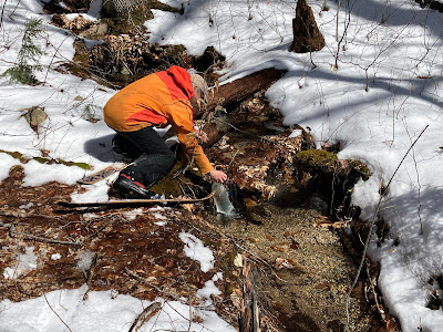
Daniel filters water from a trailside spring that was shown on the early trail maps of Waterville Valley.
The last section of Kettles Path is a steep climb through spruces on the back (north) side of the ledgy nubble known as The Scaur. The snow was thin and crusty here, not very good for skis.
Here we diverged from the trail and navigated a pleasant bushwhack route up to Irene's Path in the saddle just east of The Scaur. On this north-facing slope there was a good solid snowpack under the top layer of recent snow.
We climbed up onto a trailside ledge that Daniel calls the "Baby Scaur" and took a late lunch break. Here there is a framed view of Mt. Tecumseh with cliffs of The Scaur in the foreground. We decided to forego The Scaur itself as we would have had to remove our snowshoes/skis to scramble up the spur trail.
The "Rock of Gibraltar" is an impressive landmark near the start of Irene's Path.
As on the Kettles Path, sections of Irene's Path had barely enough snow to get through on snowshoes and skis.
A favorite passage along a rock wall. Irene's Path was completed in 2014 as an alternative route to the Waterville Flume, after the Flume Brook Trail was washed out by Tropical Storm Irene. The trail was built by the pro crew of OBP Trailworks. Daniel helped with the creative layout along the crest of Scaur Ridge.
The trail meanders through both conifers and hardwoods along the ridge.
We dropped partway down the cold and windy north side of the ridge, where Irene's Path descends through dark woods into the Flume Brook valley.
After a gentle traverse, the trail makes a very steep drop down the flank of the ridge to a fine viewpoint. The snow was hard and crusty here, tough for skis, so Daniel headed back up to the ridge while I made a rather sketchy descent on my snowshoes down to the vista.
This view of Mad River Notch flanked by the Osceolas and the west knob of Mt. Kancamagus is unique to Irene's Path.
Owl's Head Mountain in the Pemigewasset Wilderness can be seen in the distance through the Notch.
A nice angle on the Osceolas, including the Painted Cliff under East Peak.
After climbing back up the steep pitches, I followed Daniel's tracks on a bushwhack up to the ridgecrest.
In contrast to the cold wind, dark woods and crusty snow on the north side of the ridge, on the south side there was warm sun, a thin cover of mushy snow, and bright open hardwood forest.
We continued along the ridge to a favorite open sugar maple glade that each of us had been to before.
Bare ground! A wonderful place in the spring sun.
The northern Flat Mountain and Sandwich Dome could be seen through the trees.
Daniel takes in the scene from atop a convenient boulder. It was actually quite a scramble to get up on it - I didn't try.
Old and gnarled.
Looking back up at a beautiful spring scene.
Lots of boulders on this slope.
Starting on our bushwhack down the vast, hardwood-cloaked south slope of the ridge.
The sharp profile of Jennings Peak.
Partway down we came to a nameless brook. A tree shadow gave the illusion of deeper snowpack than there really was.
We followed the tumbling brook down through a shallow ravine.
Pileated woodpecker at work.
This proved to be a delightful descent in late afternoon sun.
In a flat area the brook meanders through a fine stand of white ash.
Heading into the evening sun.
Tripyramids from Depot Camp clearing on Livermore Trail.


No comments:
Post a Comment