Taking advantage of the long daylight hours, I made a longish loop over Sandwich Dome using the Smarts Brook Trail, a bushwhack up to the Algonquin Trail via an old landslide scar, the Algonquin Trail to the summit, and a return via the Sandwich Mountain Trail and Smarts Brook Trail. It was a cool, windy and mostly cloudy day, but the views were good and the bug population was zero. Though I was on trail for 9 1/2 miles of the 11+ mile loop, I saw no other hikers.
Along the Tri-Town Trail, these beech sapling leaves had been shriveled by a recent hard frost.
The lower of Sandwich Dome's two Black Mountains peers over behind the beaver meadow along the Smarts Brook Trail.
Into the Wilderness at the 2.6 mile mark.
After crossing a tributary brook, I headed off-trail up a spur ridge of the higher Black Mountain. I had ascended this ridge in 2019 and knew there would be open hardwoods up to nearly 2500 ft. There are many fine sugar maples in these woods.
A sugar maple triad.
Looking up at the canopy during one of the day's infrequent sunny breaks.
A band of thicker forest awaited at the top of the hardwoods.
A fallen bird nest, presumably from last year's nesting season.
Above the dense band, the spruces opened up beautifully, just as I remembered.
A steep slope, but the woods remained open.
Around 2900 ft. I came to a neat little plateau with a small meadow-like area, hemmed in by a steep mossy wall.
A trampled area and some old dried-up pellets showed that this has been a moose hangout.
Looking back at the meadow area as I start to head across the slope to the old slide patch.
This approach entailed some steep sidehilling, but the woods remained open.
I crossed a steeply pitched brook that originates high on this slope.
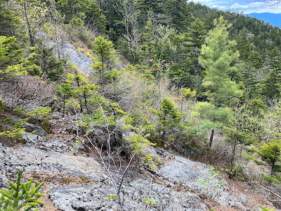
After a brief tussle with some dense scrub, I emerged at the edge of the old slide patch. I haven't determined when this slide fell, but it must be fairly old as much of its track is revegetated with a variety of shrubs and small trees.
From this vantage I could see that rain showers were moving in over Mt. Osceola and Mt. Tecumseh. Darn! But during my hour-long stay at the slide there were only a couple of light sprinkles.
The views were good, looking down into the Smarts Brook valley, flush with spring greens, and across to Acteon Ridge, including the cliffs of Sachem Peak. Welch-Dickey and Mt. Moosilauke are seen in the distance.
Great angle on Sachem Peak, with Mt. Tecumseh beyond.
Looking SW to Mt. Kineo, Carr Mountain and distant Smarts Mountain.
Several sets of steep ledges remain open on the old slide.
A side view of the slide track. It was a steep one.
Heading up the steep slope from the slide.
A mossy drainage that feeds into the slide.
The woods soon opened up and remained that way to the top of the ridge.
Nice glade approaching the 3400-ft. col between Black Mountain and Sandwich Dome.
On to the Algonquin Trail, a gem of the Sandwich Range Wilderness.
Evidence of the fine work by trail adopters N.H. Hiker and Steve LaRocca. Thank you!
I found a little peek out to Mt. Israel with Lake Winnipesaukee and the Belknap Range beyond. Down below is a large beaver wetland in the Cold River drainage.
A glimpse of the Sandwich Dome summit ahead.
This is a wonderful, remote wooded ridge walk at mostly easy grades until the final climb to the Dome's summit.
Near the top of the climb there's a view south to distant peaks as far as Mt. Monadnock.
The ledges at the summit of Sandwich Dome.
What a view, looking north to the high peaks.
Prominent in this part of the view are Mad River Notch on the left and Mt. Carrigain on the right.
The Osceolas, with the Franconia Range behind on the left.
Scaur Peak, the Tripyramids and West Sleeper.
Middle and South Tripyramid, showing the South Slides, which were once much more open. Carter Dome peers over in back.
A lonely patch of monorail on Sandwich Mountain Trail.
I had read trail reports noting extensive blowdowns on this ridge. They weren't kidding! Trees, limbs and branch tips were down everywhere.
I came through here in early April and there was nothing like this.
Yikes!
Smarts Brook Trail, my descent route, had much less blowdown.
The upper section of this trail is very wild and beautiful. Here there was a glimpse across the valley to the Algonquin Trail ridge.
Moderate grades and generally good footing on this long, lightly-used route (5.7 miles to Sandwich Dome from the trailhead).
Wild spruce forest.
Smarts Brook, high in the valley.
Boulder cave beside the trail.
Monster rock.
Cascade at trail crossing.
A peek up at the Sachem cliffs.
Smarts Brook Cascade, with dusk drawing on.


No comments:
Post a Comment