
On a calm, relatively warm day I enjoyed a good adventure on Mt. Moosilauke. On the way in I checked out "Put's Path," a new winter bypass of part of Ravine Lodge Rd. cut this fall by DOC. I ascended Gorge Brook Trail to "Last Water," then went off-trail to climb the most prominent of the slides in the Gorge Brook valley, the route of the long-abandoned DOC Gorge Brook Slide Trail. Above the slide I bushwhacked to the Carriage Road and descended via that trail, Snapper Trail and lower Gorge Brook Trail.
Ravine Lodge Rd. was a sheet of ice, so I parked at a good pulloff across Rt. 118 from the road entrance and hoofed it up to the winter parking area.

I discovered that I was the only chicken driver this day.

Put's Path starts right across from the parking area.

It was named in honor of Putnam "Put" Blodgett, legendary Dartmouth outdoorsman and mentor. When I worked at Bretton Woods in the 80s, Put was course chief for the major XC ski races that were held there.

It's a pleasant walk paralleling the road just above and to the east, following an old logging road. Keep an eye out for cut stubs.

A view of South Peak from an opening under the powerline.

These new signs point the way for trail access at the fork where the service road descends below Ravine Lodge. That is now the route to access Gorge Brook Trail.

All was quiet at the lodge.

The Class of 1982 Memorial Bridge over the Baker (Asquamchumauke) River.

DOC trail signage.

The section of Gorge Brook Trail ascending from the river was a bony, tedious mix of rock and ice. The adjacent woods were largely bare.

The only really thick ice flow came shortly after the first bridge over Gorge Brook.

Love the open woods on the 2012 relocation above the Snapper Trail junction.

At "Last Water" it was great to chat with Rick Barrie and his companions Chris and Renee, on their way down from the summit after enjoying superb views on an Adirondack-visibility day.

Here I left the trail, crossed several branches of Gorge Brook, and headed up the valley to the slide track through open woods. There was about 5" of crunchy snow here.

Slow going up the lower slide track, steep and rocky with deep pockets of snow.

Careful foot placement required.

After a 200-ft. ascent I reached the first open area on the slide.

On the slide there was a mix of soft and hard snow. Lots of step-kicking and spike-stomping.

The only major ice bulge I encountered.
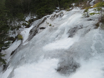
This strip provided a route around the bulge. Near the top of this strip the snow cover was thin and slick, so I took to the woods for a brief bypass.

First views out over the valley. As predicted, morning sun had given way to gray skies.

Lots of weaving to find a route up the slide.

One of two old DOC blazes I saw. The Gorge Brook Slide Trail was opened by DOC in 1966. It was "intended to be used in only one direction - uphill." The AMC White Mountain Guide noted that it afforded "more of a challenge than most trails in the area, because of its steep and rocky terrain."It was abandoned in 1980, though parts - but perhaps not all - of the trail can still be found and followed. Adding to the challenge are several adjacent old slides on this wall of the ravine. Its extreme steepness and sometimes obscure route make it suitable for experienced off-trail hikers only.

Looking up at the broad East Peak of Moosilauke.

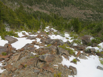
The most open part of the side is a swath of broken rock at ~3700 ft. This exposed area had less snow cover.

Down-look.
View from the swath. The 1978 DOC Trail Guide to Mount Moosilauke states that this slide fell in 1948. Another source that I can't recall said it came down in 1927. Further research needed.

Impressive views from near the top of the slide at ~3900 ft.

Zoom on Mt. Carrigain and the Hancocks.

Tripyramid.

From one slide to another.

The grade remains steep in the woods above the slide.

This was a real slog as there was nearly a foot of soft snow in the woods at 4000 ft. It's been many moons since I postholed this much. What a contrast with the valley below!

In a few places I went in to my knees.

Open woods angling up and across to the Carriage Road.

The upper part of the Carriage Road had a packed snow surface, ideal for fast spiking. Then mostly ice down Snapper, Gorge Brook and the lodge road, making it out before the predicted bad weather came in.


"I discovered that I was the only chicken driver this day."
ReplyDeleteFrom the looks of that road, I'd say you made the right choice!
Nice whack Steve
ReplyDelete