
Continuing a series of wanderings on the west side of Mount Tripyramid, I paid a return visit to The "V," a small flume-like gorge on Slide Brook that was once well-known to geologists and Waterville trampers, but is now disguised by a mantle of vegetation and mostly forgotten. With a start after 1:00 pm in December, there would be little time to linger on an 8-mile trek, albeit on easy-graded trails.
Middle and South Tripyramid were snow-caked as seen from the Depot Camp clearing along the Livermore Trail.

A fresh coating of 2-3" of powder covered up the ice along the Livermore Trail and provided a surprising amount of grip. Spikes were still the footwear of choice to avoid a random slip. I had first tracks beyond the junction with the Upper Snows X-C Trail.

Entering the Wilderness after an easy skip across Avalanche Brook.

North Tripyramid looms through the trees.

Slide Brook starting to look wintry.

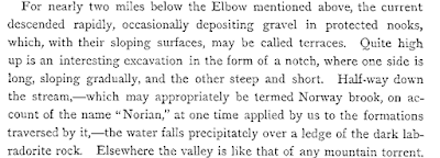
Black Cascade, notable to geologists for its fine exposure of dark gabbro bedrock.

A mile up the Mount Tripyramid Trail there was almost enough cover for snowshoeing.

Inviting corridor. Not far beyond, I made the steep and thick bushwhack down to "The V."

As far as I can tell, the first published mention of The "V" was in an 1876 article in Appalachia by Charles E. Fay, one of the founders and early leaders of the Appalachian Mountain Club. As recounted in "A Day on Tripyramid," in 1874 Fay and a companion followed Slide Brook up to the 1869 South Slide, passing by the "V." Fay surmised that the chaotic surge of the slide had scoured the gorge of all vegetation.

In his early guidebook to Waterville Valley, published in 1892, 1904 and 1916, Arthur L. Goodrich noted The "V" as one of the region's interesting features.

It also appeared on Goodrich's trail maps
of Waterville Valley, shown about halfway between
the mouth of Cold Brook and the foot of the South Slide of Tripyramid.
As shown on this 1915 edition of Goodrich's map, a crossing trail was cut between the Woodbury Trail
(now abandoned) up Mt. Whiteface and the trail leading towards the South
Slide; at its NE end it crossed Slide Brook at the head of the "V." This path was soon obliterated by logging. The AMC White Mountain Guide made note of "the small flume called 'The V' " in its Tripyramid trail descriptions through its 1948 edition.

Though not labeled, these photos from the WVAIA archives appear to show The "V" in its former guise of bare ledge: steeply sloping on the left (north) side and cliff-like on the right (south) side. The incline of the brook looks steeper in these photos than it does on the ground.

The floor of the gorge is now choked with blowdown and much of the sloping ledge on the left side is populated with shallow-rooted conifers, but the general V-shape can still be discerned.

The "edges of broken strata" described by Fay are still exposed on the south side.

In Part II of his The Geology of New Hampshire, published in 1877, state geologist Charles H. Hitchcock also noted this gorge, which he visited during his 1871 excursion up Slide Brook. He called it "the Notch." In this passage he also noted Black Cascade, found downstream on Slide Brook (which he called Norway Brook).
At the upper end of The "V" are a small cascade and pool, hard to see with the snow.

The south wall is precipitous.

In their article, "Geology of Tripyramid Mountain," published in a 1911 issue of the American Journal of Science, L.V. Pirsson and Wm. North Rice also made note of The "V" and marked its location on the accompanying map.


The jointing can be seen in this exposed outcrop on the south wall.

After a half-hour exploration, it was time to head for home. Revegetation has made The "V" a less striking formation to see than it was shortly after the South Slide fell, bit it's still an interesting spot. Perhaps a future slide will scour it out anew.


Excellent report, Steve. Really enjoyable.
ReplyDeleteThe short unnamed path between V and Woodbury trail is shown in the 1922 AMC Guide and described as striking the "Whiteface Airline" instead of the Woodbury trail, which is odd because the trail along Cascade brook is described as woodbury trail in the same chapter.
ReplyDelete