A hot and humid, partly sunny day with views galore on Mt. Webster, the impressive peak that forms the east side of Crawford Notch with its long line of cliffs, slabs and slides. I began with a short bushwhack to the lower part of the rubbly slide in Landslide Gully, then traversed the mountain via the Webster Cliff Trail - one of the great ridgecrest routes in the White Mountains - and the Webster-Jackson Trail.
Before heading over to Landslide Gully, I visited the site of the infamous Willey Slide of 1826, where a sign marks the rocks around which the slide split, sparing the home of the Samuel Willey family from destruction. Ironically, the family and hired hands - nine people in all - were killed when they fled the home for a nearby shelter when the slide came roaring down.
This plaque also marks the site.
Just across Route 302, I followed the gentle Sam Willey Trail a short distance to where it crosses the outwash from Landslide Gully, and headed up alongside the rock-strewn track of the slide.
It was not far up to the open lower end of the slide, chock full of unstable rocks that were wet from the previous night's rain and from the humidity.
Pearly Everlasting is a common inhabitant of slides.
Due to the treacherous footing, I only climbed high enough to catch an intimate view across to the location of the 1826 Willey Slide, which is completely revegetated nearly two centuries later. I believe the track of the slide is indicated by the narrow cut seen left of center. Below the cut the track curves to the right to the location of the Willey Boulders.
Mt. Willard and some of the slabs on Mt. Webster seen across Willey Pond.
On to the day's main event.
Al Robertson was one of the founders and early leaders of the AMC Four Thousand Footer Club.
The bridge over the Saco River that was dedicated to Al Robertson.
The lower part of Webster Cliff Trail climbs moderately through hardwood forest and at one point swings left up this rock staircase. Along this section i was passed by a half-dozen AT thru-hikers.
Good axe work by the AMC Trail Crew.
A tricky ledge scramble at the site of an old slide.
It's a long grind - 1,750 ft. up in 1.8 miles - to the first ledge outlook at 3020 ft., but what a view of the Willey Range and Crawford Notch! This is a worthy destination in its own right for a solid half-day hike, though the climb today was grueling with the high humidity.
Bondcliff, Mt. Bond and Mt. Guyot peer over the plateau that holds Ethan Pond.
Looking up the ridge to the next ledges.
Dramatic down-look to the floor of the Notch.
Looking south.
The rock slab known as the Willey Slide to ice climbers. This is some distance north of the site of the 1826 Willey Slide.
The Willey House site and Willey Pond.
As the trail heads north up the crest of the Webster Cliffs, it crosses a series of open ledge outlooks. Here is the view looking back from the next outlook.
Between the outlooks the trail ducks back into conifer woods, sometimes at easy grades as shown here, at others climbing rough rocky pitches.
Ever-changing perspectives on the Notch. This spectacular stretch of trail, from the floor of the Notch to Mt. Webster - was cut in 1914 by noted AMC trail-builders George Blaney, Charles W. Blood, Nathaniel L. Goodrich and Paul R. Jenks. The project took them just four days.
Looking up the ridge.
After a steep ledgy scramble - a phrase that applies frequently to this trail - you reach this open area at 3450 ft., marked by a large cairn.
Looking straight down at the Willey House area.
The Conway Scenic Railroad's Crawford Notch train came chugging back down.
Another ledge provides a view of the southern Montalban Ridge.
Stairs Mtn. and Mt. Resolution behind a craggy spur of Mt. Webster.
The upper Montalban Ridge. Mt. Isolation is the double bump on the far left.
On the upper half of the ridge walk you encounter a number of steep, challenging ledge scrambles.
Despite the humidity, the views were excellent on this late summer afternoon. For many years, the AMC White Mountain Guide carried this endorsement for the Webster Cliff Trail: “The views along the cliffs of Mt. Webster are such that anyone with a normal appreciation of the grandeur of mountain scenery will add at least 2 hr. for their enjoyment. There is nothing finer in the White Mountains.”
Getting closer, but still a ways to go.
Nice open stretch with a perched boulder.
Looking down from what might be the trickiest scramble on the ridge.
That looks like the summit, but it's a false peak.
Wowsa!
Mid-afternoon sun floods the floor of the Notch.
Looking down from yet another steep scramble.
More ledges, more vistas.
In addition to the bigger scrambles, there are a bunch of little ones like this, making this a more tiring and strenuous trip than the stats - 3.3 miles, 2750-ft. elevation gain to Mt. Webster - would suggest.
The ridge keeps spinning out behind you.
The last major scramble, Part I.
Part II.
Looking back.
Looking north to Cherry Mountain and the Dartmouth Range from the 3910-ft. summit of Mt. Webster.
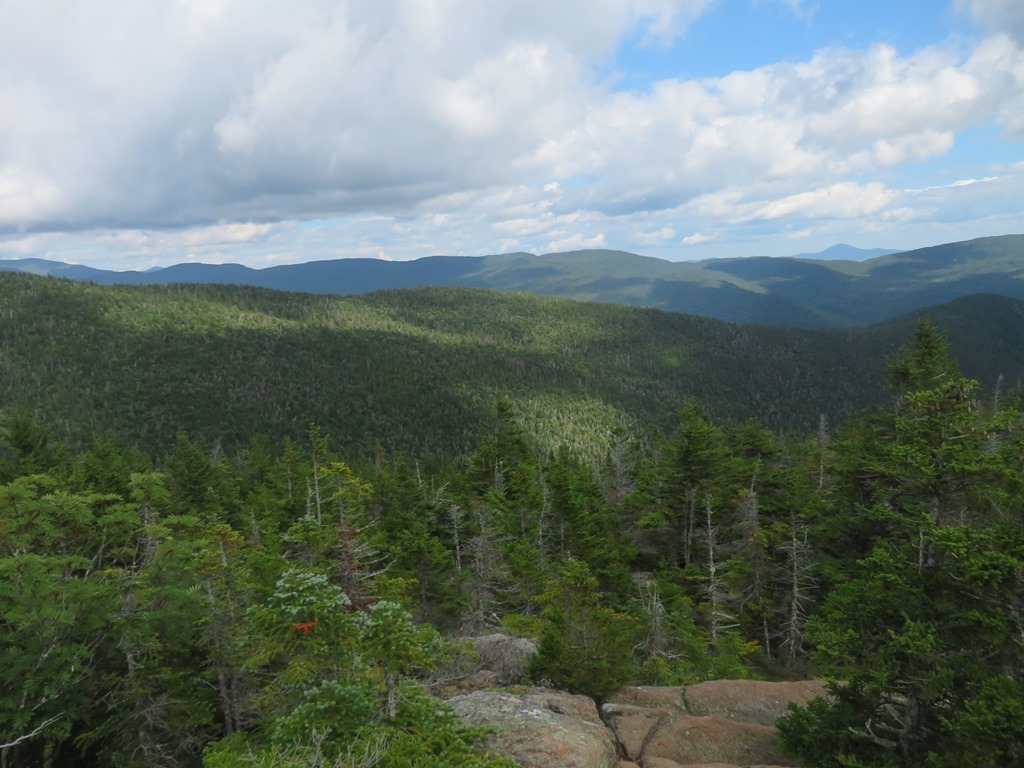
Southwest to the Pemigewasset Wilderness.
Northeast to the Presys. Mt. Washington was socked in all day.
Mt. Jackson, next destination for the Webster Cliff Trail. Not for me today.

Carol was kind enough to agree to pick me up for a ride back to my car, so I descended the Webster Branch on Webster-Jackson Trail.
Wet and rough are apt descriptions of this trail. There are many wet ledge slabs, but the rock is grippy.
Ferny fir forest.
The steep drop to the crossing of Silver Cascade Brook has gotten washed out and is quite sketchy.
But sylvan beauty awaits at the bottom. Then it's a steep climb back up to the trail junction and a generally rough and rocky walk out on the lower 1.4 miles of Webster-Jackson Trail.


The Webster Cliff Trail has been on my list for years but I have never hiked it. Your photos and descriptions are very inspiring. Thanks Steve!
ReplyDeleteThis is one of my favorite hikes in the Whites.
ReplyDeleteGreat description and pictures of the Webster Cliff Trail, Steve. It's been a long time since I've been on that trail, but your report is making me want to go back soon!
ReplyDeleteDefinitely a great hike, though it seemed harder than ten years ago!
Delete