A balmy Indian Summer day and hardwood hills at peak foliage - what more could you ask for?
Undercast hanging over Lincoln, from viewpoint on Rt. 118.
I started the hike on the Warren to East Haverhill Rail Trail.
I followed the old route of the Appalachian Trail up to the Wachipauka Pond Trail, a section of the current AT. The old route still had a few faded Dartmouth Outing Club blazes.
Gorgeous hardwood walkin' on the Wachipauka Pond Trail.
Overhead color.
Sparkling water at Wachipauka Pond.
Orange-tinted slope of Mount Mist.
A colorful corner.
A trio of river otters cruised by, snorting and diving.
A bushwhack behind the shore led to a view up to the great cliff of Webster Slide.
I wanted to try something different on the way up to the summit of Webster Slide Mountain. Note the ledge slabs on the south side of the mountain, center left in this Google Earth image.
In a more recent image, taken after Tropical Storm Irene, there is a new slide extending below the eastern slab. Worth checking out.
Soon enough the terrain turned steep and rough, with rocks and holes a'plenty.
Cutting across the slope to the slide area.
Emerging at the base of the western of the two original slabs.
Looking up from the base of the eastern slab.
Looking down at the slide area, with saplings springing up.
View south across to Mount Mist.
Carr Mountain beyond a corner of Wachipauka Pond.
Continuing up the mountain, climbing alongside the western slab.
A small cave.
Vista across the top of the western slab.
Wachipauka and Carr.
Smarts Mountain and Mount Cube beyond Lake Armington.
Where the terrain eased off near the top of the mountain, I whacked across to the DOC side trail that leads steeply down to the "Southwest View."
This perch, looking across at Mount Mist, is located at the top of the eastern slab I had visited down below.
Site of the former DOC shelter near the summit of Webster Slide. It fell into disuse and was burned by DOC in 1978.
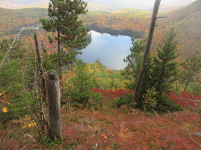
One side path leads to this blueberry scrub and red pine area looking down at Wachipauka Pond.
A side path to the left (north) leads to the main viewpoint, with a striking bird's eye view of the pond.
A steep, careful whack to lower ledges led to a full view of the pond, with Carr and Kineo on the horizon.
Nice colors on the flank of Wyatt Hill.
A paddler explored the northern finger of the pond. There is a 4WD access road to the south end of the pond.
Lounging in the Indian Summer warmth.
Later in the afternoon Mount Moosilauke finally emerged from its shroud of cloud.
Colorful woods on the Webster Slide Trail. Click here for more on Webster Slide Mountain.


Great pick for the day! Beautiful!
ReplyDelete