
SOUTH SLIDE - MT. OSCEOLA: 3/13/17
It was a fine late winter day for a bushwhack with Mark Klim to the huge slides that fell on the south side of Mt. Osceola during Hurricane Carol in 1954. An amazing place! (Thanks to Dennis Follensbee, aka alpinebee, for intel on this whack.)
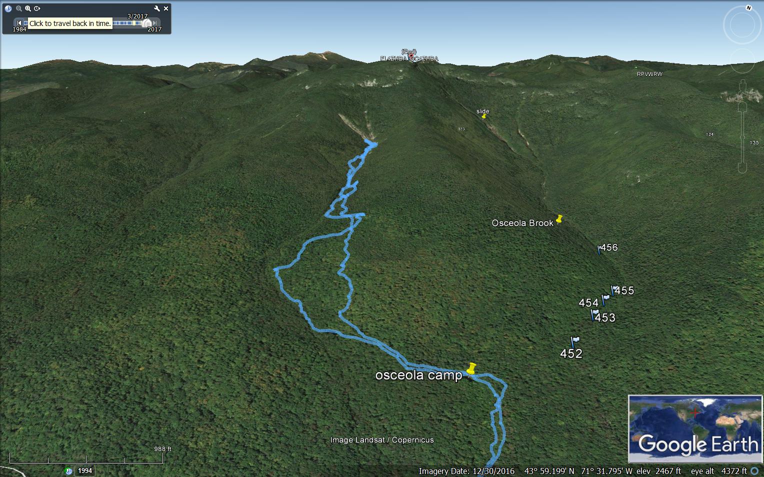
The V-shaped slides are a prominent landmark from the village of Waterville Valley.

We approached from Tripoli Road and Osceola Vista Campground, bushwhacking between Waterville XC trails and hopping on them only for bridges over the West Branch of the Mad River and the brook that drains the slides. After crossing that brook, we passed this rock-gripping yellow birch.

We enjoyed the great bushwhacking conditions in the hardwoods.

An old sugar maple to stop and admire.

Soaking up the sun at the site of Osceola Camp, used by the Parker-Young Co. in the 1940s.

An interesting spot for a picnic table - at a clearing marking the far northern end of the Waterville Valley XC ski trail system.

From there we followed an old logging road pockmarked with moose postholes.

When that petered out we headed up the slope, crossing another old logging road.

We ascended for a while through some open mixed woods.

We emerged in a young open hardwood forest in brilliant March sun. This was a large old clearcut dating back 30 or 40 years.

Moose browse.

At the top of the hardwoods we found this giant glacial erratic.

An impressive chunk of stone!

A snow ramp provided access to the top.

Nearby, Mark found a La-Z-Boy recliner in the woods.

After a break, we briefly followed this old tote road down towards the brook. From there, our route varied in the usual trail-and-error of finding a passable route up through a steep-sided valley.

We came down to the brook several times, and it was generally rough and rocky....

...and closed in by trees and terrain.

We slowly forged onward, seeking the path of least resistance.

We found an occasional section of good going right alongside the brook.

To avoid a steep sidehill, we climbed high on the eastern slope to an old tote road, but it was so crammed with small conifers that it was nearly impassable, so we dropped back to the brook. Encountering more severe sidehill, we made a difficult climb on very hard crusty snow up on the west side, followed a faint old tote road along the slope, then dropped down to this nice open spot (ledgy in summer) high up in the ravine. The top of Mt. Osceola could be seen above.

We appreciated this fine open sunny spot after pushing through ranks of prickly conifers.

Mark checks out a gravel slide on the east side of the ravine.

As part of our back-and-forth across the brook, we crossed this snow bridge.

At the next ledgy area along the brook, the slide could be glimpsed ahead.

Looking back at our tracks.

Thanks to a creative route fashioned by Mark, we were able to use the brookbed itself for the final approach.

Arriving at the bottom of the slide, we found, as expected,a large ice bulge covered with a thin layer of snow presenting an obstacle. The key to the highway was a steep route ascending along the right edge. We had carried crampons, but were able to make it all the way with our mountaineering snowshoes.

This might be a cascade in summer.

Side view of the ice bulge.

Holy cow! In the bright March sun, this expansive scene was a jaw-dropper.

Wide open and massive.

Mark makes his way over to the bare gravel strip we had spotted from in town...

...and finds himself a rock seat. A tiny figure in a giant slidescape.

Soaking up the sun.

Looking up the wider left-hand slide. In a 1959 study of White Mountain landslides and their revegetation, Edward Flaccus measured the slope of this slide as 29 degrees on the average with a maximum of 34 degrees. It was 367 yards long with an average width of 75 yards, and covered 5.7 acres, with its track extending 1.5 miles down the brook. He estimated that 29,724 tons of debris were moved by the slide. This was one of 6 slides that crashed down the slopes of Osceola during Hurricane Carol on August 31, 1954. There were two in the ravine of Osceola Brook (which we had visited a week earlier) and three on the northern slopes.

Sandwich Dome and Waterville Valley ski slopes.

We climbed up the gravel strip, where Mark stood tall as king of the slide.

Looking across the twin icefalls where the two slides meet.

The left slide icefall.

The right side icefall.

View out to Flat Mountain, Sandwich Dome and the village of Waterville Valley.

Zoom on the view.

The footing was tricky for descending the partly frozen gravel and rock.

Another angle on the icefalls.

We hadn't planned to climb to the top of the slide, but from this perspective it looked doable with crampons and caution. But then we would have to descend the slide - a dicier proposition - or push up through likely dense conifers to the Mt. Osceola Trail and make a 5+ mile descent. We were happy to linger at the wide lower expanse of the slide and just take it in.

A crevasse and frozen pool below the gravel strip.

Descending along the edge of the ice bulge.

Mark probes another crevasse at the bottom of the ice bulge.

Looking back up at the ice bulge, and our tracks along the edge.

Heading down.

Last look back. We will not soon forget this place.

Tight terrain along the brook.

Crossing the brook to seek better going on the far side. Having seen the lay of the ravine on the way in, we found a better route on the way out.

Doing the blowdown duck on a sidehill.

Eventually we gained some open woods on easier terrain.

Down in the friendly hardwoods, we saw many "bear nests."

A popular bear tree.

Sliding claw marks.

Tripyramid from Osceola Vista Campground.

Looking back to where we'd been. A memorable day!


Hi, I've been skiing a lot of slides and had this one as a possibility to hit next, but in your pictures it looks to mostly be ice. Think it ever fills in better with snow? This is only my second year in New England so I'm not sure if 2017 was just a low snow year or maybe you went to it during a warm spell, or if this is how it will normally look.
ReplyDeleteHi Andrew, It's probably better filled in with snow this year, it being a big snow winter, but it does get alot of sun so I assume there's a lot of thawing and freezing. It was a pretty gnarly whack to get in to this one. The good thing is it's highly visible from the town of Waterville, so with binoculars you could get a good idea of its condition. -- Steve
DeleteGreat, thanks Steve. I've been skiing North facing slides and they've been filled in great, but you're probably right about the thawing and freezing on the South facing aspect.
DeleteI like the idea to check it out with binoculars ahead of time, I skied North Tri last weekend and that is a great backup plan if the Osceola South Slide looks bad from town. Thanks!
Thanks for the info Steve - made it out there yesterday. You weren't lying about it being a gnarly whack!
ReplyDeleteThe slide definitely had better snow coverage then when you visited, but there was a layer of ice right under the snow which made the way up a bit treacherous. Coming down was nice though as I glided over the top and didn't cut down to the ice.
Great! Glad you made it out there and were able to get a run in. I don't think it gets skied very often compared to the slides on the north side of Osceola. Any photos?
DeleteGot a couple photos, but don't know how to share them. I haven't heard of anybody skiing this slide before (although I'm sure someone has), but I enjoy getting out to explore the less visited parts of the mountains. Will definitely visit the northern slides at some point.
ReplyDelete