
BELKNAP RANGE RAMBLE: 5/8/14
On a sunny spring day with temperatures soaring to the sixties I drove down to the East Gilford Trail trailhead on Wood Road in Gilford for a long, leisurely ramble on the Belknap Range. These little mountains on the SW side of Lake Winnipesaukee top out at only 2384 ft. but are blessed with many open ledges and an extensive network of well-maintained trails, with several options for rewarding loop hikes. (Click here for a great trail map, photos and trail descriptions on a site created by Weldon Bosworth with much help from Dave Roberts, Hal Graham and others. Some of the trail descriptions are adapted and used with permission from the AMC Southern New Hampshire Trail Guide.) The Belknaps are one of the best hiking areas in the state, especially in early spring when the high peaks are still plagued with rotten snow, monorails and ice. Today I wanted to check out a relocation underway by the Belknap Range Trail Tenders (BRATTs), the dedicated group of volunteers who look after most of the trails in the range. Along the way I would walk part or all of eight trails, hit three summits of the "Belknap 12," and visit beautiful Round Pond.

I started off on the East Gilford Trail/East Gilford Fire Road route and soon hung a left with the Fire Road, which provided easy, pleasant walking.

Next I turned left onto the Round Pond Trail, ascending through a fine hardwood forest that almost made me feel like I was back in the Catskills.

In this section I saw my only red trillium of the day. The spring flowers seem to be quite late this year!

The trail descended through old hardwoods down towards Round Pond.

It's always a thrill to approach this picturesque and secluded spot.

Shortly after I reached the pond, a pair of fast-moving hikers came by. It was Rick Barrie, who maintains the Mt. Roberts Trail in the Ossipees, and Giff Kriebel, volunteer extraordinaire for the Pemi Ranger District on the WMNF. They were doing a traverse of the range from Mt. Rowe to Mt. Major.

Looking across the pond to the broad summits of Mt. Klem (L) and Mt. Mack (R).

Neat open woods on the slope above the pond.

I admired this gnarled old beech tree.

The relocated section of the Round Pond-Piper Link will follow this old fisherman's path behind the shore of the pond.

The trail runs right along the water's edge on the east shore.

The junction of Round Pond-Piper Link with the Mt. Klem-Mt. Mack Loop.

Spruce forest heading up onto Mt. Klem.

An open glade up near the crest, again reminiscent of the Catskills.

The north outlook on Mt. Klem is one of my favorite spots in the Belknaps.

Mt. Moosilauke, with ice still seen on the cliffs of Jobildunc Ravine to the right of the snow-capped summit.

The Sandwich Range, peering into The Bowl between Mt. Whiteface and Mt. Passaconaway.

Mt. Washington behind Black Snout in the Ossipees. Mt. Chocorua peeks over on the R.

I took a long lunch break here in the sun.


Klem just cracks the 2000-ft. mark.

Lots of nice woods on this hike.

A southeastern viewpoint on Mt. Klem.

Mt. Mack in sight ahead.

Neat forest in the broad col between Klem and Mack.

The summit of Mack, with old and new communications towers.

A fine outlook ledge on Mt. Mack, looking towards Piper and Belknap Mountains.
Close-up of Belknap, showing some of the ledges on its east side. I'd be heading up those ledges along the Boulder Trail.

The long, ledgy crest of Piper Mountain.

Heading down a logging road section of the Round Pond-Mt. Mack Trail.

A newly cleared outlook to Piper and Belknap.

Down near the shore of Round Pond the trail passes through this campsite of the Griswold Scout Reservation. The Daniel Webster Council operates Camp Hidden Valley and Camp Bell on the 3,200-acre reservation on the south side of the Belknap Range in Gilmanton. the reservation includes parts of the ridge and the eastern shore of Round Pond. The land is open for public recreation. There are a number of trails approaching the ridge from the camps to the south; permission to use them is only required during the camp season of June through August.

View of Belknap Mountain across the pond.

A newly relocated section of the Round Pond-Piper Link, one of many examples of the fine work done by the BRATTs.

Relaxing back on the west shore of Round Pond for a few minutes. Saw three Hooded Mergansers out on the water.

Next I followed the Round Pond-Piper Link towards Belknap Mountain. This lightly-used trail had a nice remote feeling.

Unique signage at the base of the Boulder Trail.

This is one of the more rugged trails in the Belknaps, ascending 550 ft. in 0.4 mi., including this impressive talus slope.

Looking down the talus.

Southern vista across the rockfall.

Up we go!

The trail then emerges on some big ledge slabs.

Sat here for a while admiring the view SE towards Manning Lake.

The route up the ledges is well-marked with blue-topped cairns.

A steep slab near the top of the Boulder Trail.

Junction with the East Gilford Trail.

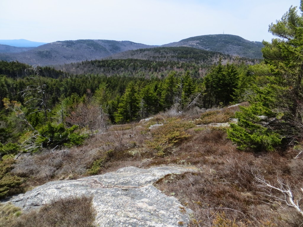
A fine eastern view along the East Gilford Trail, including Mts. Klem and Mack and Round Pond.

Ledges by the East Gilford/White Trail junction.

I didn't get
to the tower atop Belknap until after 5:30, and longtime firewarden Hal
Graham had closed up for the day. In addition to his fire tower duties,
Hal is President of the BRATTs and a Director of the Trailwrights trail
maintenance volunteer group. Hal and his wife Peggy have devoted
thousands of hours of trail work to the Belknap trails and many other trails around
the state. He's also been a tremendous help to me in updating the AMC Southern New Hampshire Trail Guide. Thanks, Hal and Peggy, for all you do!

A good view day today, including these southern NH peaks and nearly two dozen 4000-footers.

I descended via the East Gilford Trail, which features a lot of sometimes slippery ledgy footing.

An interesting piney/ledgy area on the flank of the mountain.

The going was easier after this steep, rocky pitch, ending a full and very rewarding circuit in the Belknaps.

For those interested, a GPS track of the day's route.


Excellent report, Steve!
ReplyDeleteWish this trail system wasn't such a far drive from my home in Bethlehem since it surely looks like there would be a lot of "new to me" exploring to do down there. :-)
John
Thanks, John - I wish it was closer too. I'd go there more often. Maybe we can ride down together some time.
DeleteSteve
(Might have lost my first comment? Who knows, just delete if this is a double) Nice to see you in our neck of the woods. I get to see the Belknaps every day, when I'm around town. Good hiking for this time of year, too. Good news that they cut the trail to the summit of Klem. Used to be that the herdpath was a little difficult to follow at the beginning, but got more obvious closer to the actual summit. The old flagging helped a bit, too. ;)
ReplyDeleteHi Summerset,
DeleteThanks for your comment. I really like the Belknaps, such a great variety of trails and terrain. I think that was the first time I'd been to the actual summit of Klem.
Steve