
Until last week I had never been to Thompson Falls (the one on Moat Brook at the base of the Moat Mountains, just outside of North Conway -- not to be confused with another Thompson Falls at the base of Wildcat Mountain). I had read about this spot in old guidebooks such as Starr King's and Sweetser's, and had a vague idea about an old trail leading there. The falls trail was shown on the 1942 USGS 15 minute North Conway quad, and was described in the AMC White Mountain Guide into the 1950s. But little information could be gleaned from the two current guidebooks devoted to the region’s waterfalls, and the location of the falls was not to be found on the various White Mountain trail maps in use today.
What prompted me to finally go see Thompson Falls, and also walk the Moat Mountain Mineral Site Trail for the first time, was the recent decision by the Forest Service to add twelve miles of trails on the east side of the Moats to the WMNF trail system. Though most of these routes have been designated primarily for mountain biking, the old trail to Thompson Falls will be maintained as an official trail for foot travel only. I brought my measuring wheel also, as we plan to add the Moat Mineral Site and Thompson Falls trails to the next (2012) edition of the AMC White Mountain Guide. (Sorry, redliners!)
My hike plan included a trek along the Moat Mineral Site Trail, a loop around past Thompson Falls, and then an extension to White Horse Ledge via a combination of the mountain bike trails and existing hiking trails. I started at the Moat Mineral Site parking area, located at the end of High St., which leaves Passaconaway Rd. 1.2 mi. west of West Side Rd. This good, mostly gravel road leads 2.6 mi. to the parking area, which is slated for expansion in the near future.
In addition to hiking trail maps and the current USGS quad, I brought along the newly revised Conway Area Mountain Biking Trail Map, published by Mountain Cycle Guide Service. This excellent map, with cartography by the AMC's Larry Garland, shows the newly designated Moat area mountain bike trails, and also shows, but doesn't name, the Thompson Falls Trail.
There was some information about the mineral site on the kiosk.
 The mileage to Red Ridge Rd. (FR 379) on the trailhead sign is a little off (it's 1.86 mi. by the measuring wheel), probably because of the many switchbacks that were added to the north half to prevent erosion. This trail is popular with mountain bikers, and hikers in the Moat region should be prepared to share the trail with riders.
 The Mineral Site Trail offers easy, pleasant walking through an open forest of hemlock, spruce and birch. Even though it was near noon, and hot and sunny, the mosquitoes swarmed me as soon as I opened the car door, so I quickly slathered on some Ben's, making the walk much more enjoyable.
 At 0.9 mi. this sign marked the collecting area. I was expecting some sort of open pit, such as the one near the Sugarloaf Trail on North Sugarloaf, but the collecting sites were well-hidden in the woods, presumably at the end of well-beaten side paths.
 From here the trail descended through hardwoods via many gravelly switchbacks.
 At the bottom I turned R on FR 379 and walked 0.2 mi. to a gate. The unmarked trail to Thompson Falls headed into the woods on the L side of this road, 200 yards past the gate, at a point where the road swings to the R. There are no signs on these newly designated trails as yet; the WMNF plans to have them in place in the near future. Thus it took me a few minutes of wandering around on woods roads before I realized I had passed the somewhat disguised spot where the trail leaves FR 379.
 The half-mile Thompson Falls Trail was a delight, leading up through a gorgeous open hemlock forest.
 After crossing a small brook, it climbed along a bank above Moat Brook.
 The falls were 0.3 mi. up from the bottom (east) end of the trail. Though not a towering waterfall by any means, this is a beautiful spot. It was a favorite location of 19th century artist Benjamin Champney, who spent many summers in North Conway. "Thompson Falls and the Saco Valley" is considered one of his finest paintings.
I found a seat near the base of the falls, where I had lunch amidst a cool, mosquito-repelling breeze fanned by the plunging brook.

There's an interesting collection of ledges and boulders below the falls. Sweetser described them as "great masses of shattered rocks."
 Above the falls, the brook slithered gently over broad ledges.
 At the trail's upper junction with FR 379, I turned R (going L, you would reach the north end of the Mineral Site Trail in 5 minutes), and in a few minutes turned R again on an unmarked connecting path that quickly led to the Upper Stony Ridge mountain bike trail. Keeping an eye out for mountain bikers, I followed this for a mile up to the White Horse Ledge hiking trail. One of the purposes of going this way was to see how the bike trail interfaced with the hiking trail. Descending the hiking trail, you stay to the L here as the bike trail diverges R.
 In another 0.2 mi. uphill, I reached the jct. with Red Ridge Link.
 A short climb led to the top of White Horse Ledge.
 Near the crest some lady slippers were in bloom.
From the big summit slab there's a partial view east to the Green Hills.

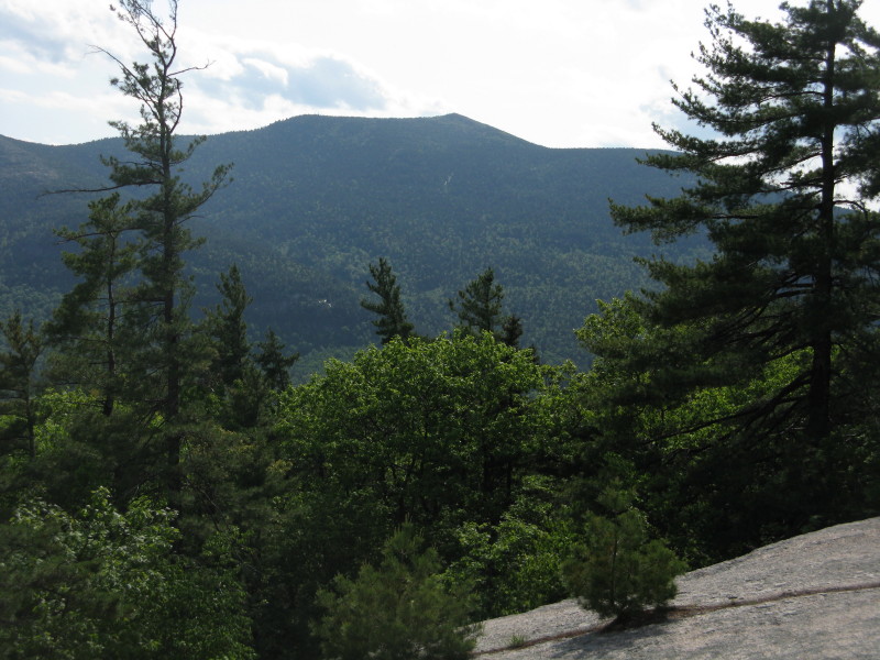
My favorite spot on White Horse is a ledge near the summit with an intimate view up to the Moat Range. From this angle you see South and Middle Moat and Red Ridge.

By moving down a bit you can also see North Moat.
 This gnarled pitch pine ekes out a living at the base of the ledge.
 After a long break here, I descended to the SE edge of the summit slab and followed a well-worn climber's path through the woods to a dramatic flat perch atop the main White Horse cliff. To the L I could see the Presidentials and Wildcats in the distance.
 Beyond the back side of nearby Cathedral Ledge, Wildcat, Carter Notch, Carter Dome, Thorn and Doublehead were prominent.
 Looking across the lush fields of the Saco Valley to Bartlett Mtn. and Kearsarge North.
The view east: Echo Lake and the Green Hills.
 Heading back, a last look at the Moats.
 For my return trip, I went down the Red Ridge Link through fine open woods.
 At the bottom I turned L on the Red Ridge Trail.
 This runs at gentle grades through a remote flat area behind White Horse Ledge.
 Where the trail crossed FR 379, I jogged L a short distance on the road, then turned R on the unmarked Way in the Woods/Tent Boulder mountain bike trail. It was midweek and late in the day, so I figured mountain bike traffic would be light. (In fact, I met no hikers or bikers on my entire 9-mile trek today.) This narrow, meandering path was fun to walk; for much of its two-mile length it led through open hemlocks with long views through the forest.
 Towards its south end it climbed to a shelf beneath an interesting talus jumble and cliff low on the flank of the Moats. This boulder cave, a smaller version of Big Rock Cave in the Sandwich Range, was a short distance off the trail.
I carefully made my way up through the big, chaotically strewn boulders to a spot where I had a glimpse up to the open talus area.
 I had a peek up at the parent cliff, from which these rocks had tumbled.
A short distance farther the trail wrapped around the massive Tent Boulder, which has a neat overhang that would be welcome in a heavy rain shower. The mosquitoes had been getting progressively worse since I had descended from White Horse Ledge, and they hounded me relentlessly on the last mile out along the Tent Boulder and Mineral Site trails. It was probably one of the worst mosquito assaults I've ever encountered. This is a cool area to explore, but be sure to bring the bug dope!
The round trip to Thompson Falls on the Mineral Site Trail, FR 379 and the Thompson Falls Trail is 4.7 miles with 800 feet of elevation gain. To add White Horse Ledge, I recommend an out-and-back route using FR 379 and the Red Ridge Trail and Red Ridge Link up to the White Horse Ledge Trail near the top, rather than using the mountain bike trails. This trek would be 9.4 miles with 1,400 feet of elevation gain. (Thanks to Peter Minnich of Mountain Cycle Guide Service and Jana Johnson of the Saco Ranger District for providing info on these trails.)


Great report about a great area!
ReplyDeleteKevin Tilton
Thanks, Kevin - I assume you've been out there a few times!
ReplyDeleteSteve
I've heard about the Moat Mineral site, but never knew where it was. One cool specimen in my rock collection is a genuine Moat smoky quartz cluster. That was a great report! It's exciting to hear about some new areas and trails being developed in the Whites. I'll definitely have to make sure to include a part of this area in my next visit to the Moats.
ReplyDeleteSteve,
ReplyDeleteThis is indeed a terrific report to someplace different (which always grabs my attention)!
Like you, my interest was piqued when I read about the recent decision by the Forest Service to add 12 miles of trails on the east side of the Moats to the WMNF trail system. It's on my long list of places to visit. And now, thanks to your report, I can see that it's a destination worthy of exploring.
John
Thanks, guys! It's great to have some new trails to explore. There could be another waterfall in that area, which may or may not be on WMNF land, and may or may not have an unofficial path. Need to do more research.
ReplyDeleteSteve