
Climbing a steep trail in the middle of a week-long heatwave is not especially sensible, but I had an itch for the Osceolas and decided to scratch it. I started early in the morning from the Greeley Ponds trailhead on the Kanc Highway, hoping to beat the heat for the steep climb up to East Osceola.

A short way in I made an easy crossing over the South Fork of the Hancock Branch. Water levels were pretty low due to a recent lack of rainfall.

The humidity was ridiculously tropical. By the time I had made the easy 1.3 mile climb to the Mt. Osceola Trail junction in Mad River Notch (2300 ft.), my shirt and shorts were soaked with sweat, and would remain so throughout the day. A check on weather.com later in the day showed the dew point at 73 degrees. Yuck!
 About 0.3 mile up, the Osceola Trail led through this nice hardwood glade, flooded with morning sunlight.
 The next section of trail angles up below the dramatic cliffs on the NE spur of East Osceola.The trail was relocated here in the mid-1980s, and the former steep lower section dropping down to Upper Greeley Pond was abandoned.
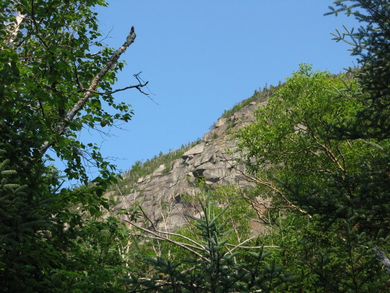
The trail weaves through an interesting assortment of boulders.
 Upon meeting the old route at 3000 ft., the trail turns right and climbs very steeply, passing to the R of a big rock slab at 3300-3400 ft. A short herd path leads to the base of this impressive face.
 The section that climbs alongside the slab is very steep and eroded, with some tricky footing. This could be a problem area in the future, should any of these crazily-angled rocks come loose.
 The climb continues steep to the crossing of an open face of fractured ledge near the top of the old slide, at 3650 ft. Already feeling the sticky heat, I took this ascent very slowly.
This spot is a fine viewpoint. I sat in the shade along the edge for a much-needed break with some food and water. A hazy view across the notch to the various summits of Mt. Kancamagus.

The hazy theme continued looking N to Mts. Huntington (in front), Hancock and Carrigain.

Looking down on those cliffs on the NE spur. Some years Peregrine Falcons nest there. Adventurous ice climbers have put up a number of routes on these crags, including one called "Drool of the Beast."
 The grade does not relent above the slide.
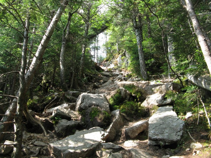
The final pitch to the ridgecrest is through this eroded chute.
 At the top there's an excellent view of Mt. Osceola a few yards to the R.
A detached part of the wild Split Cliff is seen in front of West Osceola.

East Osceola rises near at hand.

From the outlook, the climb to the summit of East Osceola is easy, then moderate, then fairly steep at the top as shown here.

Peakbaggers know that the wooded summit of East Osceola is essentially viewless.

However, in addition to the two outlooks on the way up from Mad River Notch, there is a fine NW-facing ledge viewpoint beside the trail partway down to the East Osceola-Osceola col.

Unfortunately, there was so much moisture in the air that fog rolled in, obscuring all views except the look down into the broad basin below, drained by Pine Brook and Cheney Brook.
 At the col you are confronted with the famous Osceola "chimney." I hadn't done this in a while and wanted to check it out.
 The "bypass" to the R is presumably the official route of the trail, but the scramble at the bottom of that is no piece of cake and requires caution, especially descending. I would venture to say that the chimney/bypass combo is one of the trickier spots on the "standard" routes to the 4000-footers.
A closer look at the chimney. It's fun to climb up when it's dry, and offers good footholds and handholds. A little tight near the top with a big pack.
 Looking down from the top of the chimney reminded me of the first time I climbed the Osceolas, in 1981 with Bill Vecchio of Twin Mountain. Bill had a small, energetic black dog named Jackson, who would often bound down the trail head of us. It was a foggy day, and as we descended from Osceola to the col we saw Jackson come to a sudden skidding halt ahead of us. He was a bit of a knucklehead, but had enough sense to put on the brakes just before he tumbled down into the chimney.
Above the chimney the climb to Osceola is mostly moderate to easy, with just one more steep, rough section.

There's a great stretch of easy walking along a high, narrow shoulder not far below the summit.


I arrived at the big summit ledge viewpoint to find it totally fogged in. The concrete supports serve as a reminder of the days when watchmen manned a firetower atop Osceola. This most recent firetower was removed in 1985.
 A slightly higher ledge that hosted an earlier firetower is located about 50 yards farther W along the trail and is generally considered the true summit of the mountain. It lies within a 4320-ft. contour, giving Osceola a 4340-ft. elevation by contour interpolation (adding half of the USGS map's contour interval - in this case 40 ft. - to the highest contour line).
There has been speculation that the nearby ledge with the NW view could actually be the highest point. No vista there today.
 Back at the main summit ledge, this was the best vista I saw in 45 minutes - a slight teasing look at the valley below. At least there was a refreshing breeze here, and the fog kept the temperature down.
On the return trip I stopped for a while on an outlook ledge just R of the trail above the chimney. A good closeup of East Osceola here.

Back at the slide there was a fuzzy look down into Mad River Notch.

For a minute Upper Greeley Pond was highlighted by the hazy sun.

A closeup of the NE cliffs.
 The descent off East Osceola requires careful attention to footing.
The bottom part of the trail passes through some nice white birches.

Old hardwoods at the height-of-land in Mad River Notch.
 Bog bridges along the Greeley Ponds Trail.
A towering pine next to a big boulder, shortly before the crossing of the Hancock Branch South Fork. By this point I had pretty much wilted in the humidity and was mighty glad to reach the car.


Nice trip report Steve. About how long was this trek? Pretty much a day hike? Lose a few pounds? Hehehe.
ReplyDeleteThanks, George. The stats on this trip are 7.6 miles round trip with 3100 feet of elevation gain. I took many extended breaks and stretched it out for nine hours. Book time is about 5:20. Yeah, probably lost a couple pounds of water weight.
ReplyDeleteGood lord! A couple days prior to this I decided to climb meager little Table Mt. and I don't think I've ever sweat like that before. The heat was oppressive and I think you had the hotter day for this trip. I broke a sweat just reading this and imagining that humidity all over again. I salute your fortitude Steve.
ReplyDeleteGreat report! Loved all the pics, as much as I hike the Sandwich range I've yet to visit the O's and have been wondering about the chimney. First pics I've seen of it and am excited to hit this trail soon!
ReplyDeleteHi Alex,
ReplyDeleteTable is a pretty hot climb on a sunny summer day, going up those ledges. That must have been broiling! I won't be sorry to see this humidity go back south.
Steve
Thanks Jason,
ReplyDeleteThe chimney is a fun little scramble going up, when it's dry. Overall, I think the approach to the O's is much more interesting from the Kanc than from Tripoli Road, with the steep climbing and views on the way up. Plus, if you have a little extra time you can make the easy side trip to the Greeley Ponds, two of the prettiest spots in the Whites.
Steve