
Friday, November 11, 2022

Tripyramid South Slide: 11/10/22

On the last of the marvelous sunny, 60-degree days we've enjoyed this early November, I returned to a favorite hike up the South Slide of Mount Tripyramid. I like this hike in November as you have sun nearly the whole time until mid-afternoon. In addition to the nice scenery of Slide Brook, and the excellent views from the slide, there's an option to bushwhack out through open hardwoods for nearly a mile before looping back to the trail.

On the gentle approach hike along Livermore Trail, I made a brief side trip to the site of the Swazeytown logging camp from the early 1900s.


Morning sun on the Livermore Trail.


A mandatory stop at White Cascade on Slide Brook.


On to the Mount Tripyramid Trail, a longtime favorite.


An easy crossing of Avalanche Brook this day. On the far bank a sign welcomes you to the Sandwich Range Wilderness.


Mossy cascade on Slide Brook.


Slide Brook.


A mile up from Livermore Trail, I climbed into the open hardwood forest on the broad slope to the north of Mount Tripyramid Trail.


An old bear tree.


For the sheer joy of whacking...


Sugar maple glade.


Fallen giant.


Following an old logging road in spruce forest, returning to the trail at ~3000 ft. - just below the bottom of the South Slide.


First views, from the lower open section of the South Slide. This is the earliest of three South Slides on Tripyramid. It came crashing down during an intense rainstorm on October 4, 1869. (The others fell in 1885 and 2011.)


Mt. Tecumseh is seen across the Waterville Valley.


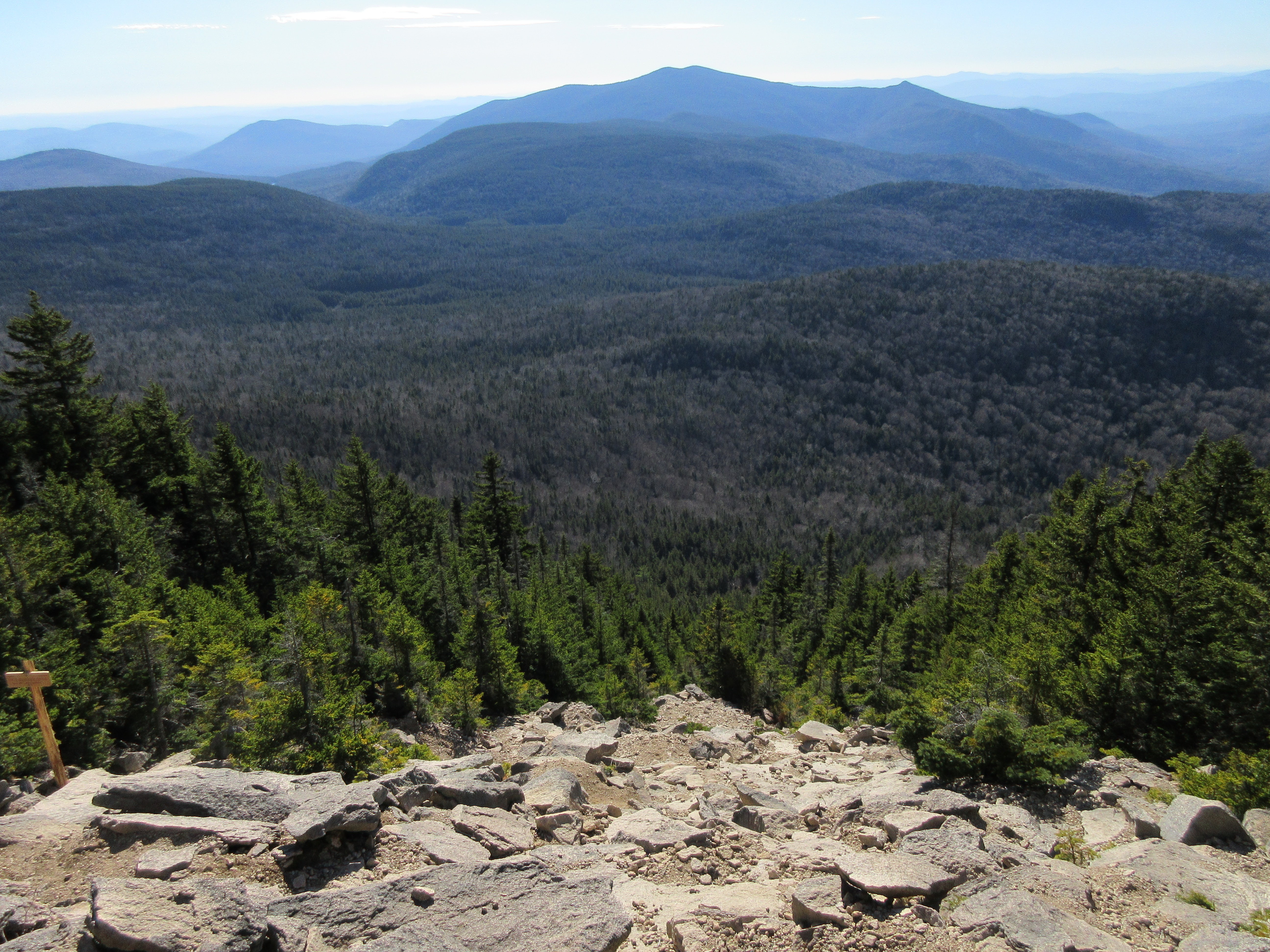
Unique to the South Slide is the view over the wild Lost Pass/Flat Mountain/Sandwich Dome region.


Jumbled rocks on the upper part of the slide.


I had heard of a new post and sign marking the easily-missed junction with the Kate Sleeper Trail, and it was in sight above.


The junction is easy to spot now. Thanks go to the Wonalancet Out Door Club and the Forest Service.


The 1869 South Slide has a slope of around 34 degrees.


Lunch spot with a view. An hour was spent basking in the amazingly warm November sun.


A descending hiker. For a number of years, the first South Slide, being at that time the only major slide on the mountain, was known as the “Great Slide.” Henry F. Walling’s 1877 map of the White Mountains labeled it “Slide of Oct. 4 1869.” In his comprehensive 1876 guidebook to the White Mountains, Moses Sweetser wrote that “The Great Slide on Tripyramid is considered by many visitors the most remarkable object among the curiosities of Waterville.” As such, he provided directions for trampers to access the slide, reaching it at the location known as “Beckytown,” ascending two miles up along the devastation of Slide Brook, and then climbing ½ mile in distance and 1,100 feet in elevation up the slide proper. “The upper half-mile,” he wrote, “is so extremely steep as to enforce slow advance on the part of the climber, whose footing, moreover, is often very insecure…The Slide contains many points of interest to geologists and other scientific men.”


Sweetser noted that trampers would be rewarded with beautiful views of Lake Winnipesaukee and the mountains to the south and west.


Struggle for survival in a harsh environment, a century and a half after the fall of the slide.


Low late day sun in a trailside sugar maple glade, not far down from the base of the slide. From here it is a generally easy 4.4 mile hike back to the trailhead. The round trip to the top of the South Slide is about 10 miles with 2300 feet of elevation gain. Caution is needed on the slide, especially descending, due to a preponderance of loose stony and gravelly footing.


Tuesday, November 8, 2022

Pilot Cliff: 11/7/22

For many years a bushwhack to the huge cliff on a western spur of the Pilot Range, a few miles northwest of Mt. Cabot, has been on my wish list. Though the cliff is within the White Mountain National Forest, there is a mile and a half swath of private land between the scenic Lost Nation Road and the WMNF boundary. I knew a less direct route to the cliff entirely on public land was possible, but I had never followed through with it. Then last week Carol and I took a ride out Lost Nation way on a sunny afternoon, and a close-up view of the cliff inspired me to finally make the trek.

On the morning of my hike I paused on Lost Nation Road for a photo of the cliff (on the left) and the 3730-ft. peak of Hutchins Mountain.


This huge slab of syenite is about 250 feet high.


To reach the cliff, I made a long southeastward bushwhack traverse through the Town of Northumberland Watershed Forest, first following the drainage of Roaring Brook, where I came upon this nice cascade.


Farther upstream was this abandoned dam and water pipe.


As I continued up the valley, I found an old logging road that was going my way for a short distance.


Nice hardwoods in the upper drainage of Roaring Brook. In studying maps of this location, some show it as Northumberland Town Forest land, others as WMNF land.


An obstacle along the whack to the cliff was a climb up and over an intervening spruce-covered ridge, which had some rough terrain with poor footing and ample blowdown.


On the other side of the ridge I descended into the valley of Parks Brook, where I was greeted by a mess of blowdown.


It took a while to work a route around this.


Ferns and better woods ahead!


Parks Brook is pretty small, high up in its valley.


Good woods on the south side of the brook.


Heading up the flank of the ridge towards the cliff.


Better than good, these were spectacular woods.


I reached the crest of the ridge at a scrubby fern meadow just below the top of the cliff, with Hutchins Mountain in sight above.


There were several moose beds in this sun-filled meadow.


A short burst of climbing brought me to the top of the cliff. Now that's a perch, with a grandstand view of Hutchins rising above the valley of the north fork of Burnside Brook. The dogleg track of an old overgrown slide can be seen at the head of the valley.


Looking up along the top of the cliff.


A beaver meadow is seen in the broad hardwood basin below.


Zoom on the beaver meadow.


A startling down-look from the brink of the cliff.


The clifftop offers far-reaching views to the south and southwest, including the summits of 24 4000-footers. An hour and a half passed quickly here in the amazingly warm November sun.


Seen here (left to right) are South and North Twin, Owl's Head, Flume, Garfield, Lincoln, Lafayette, Cannon, South and North Kinsman and Moosilauke.


Mt. Cabot and Mt. Waumbek are seen beyond a spur of the Pilot Range, with Mts. Adams and Washington peering over between them.


This rocky knob juts up behind the cliff, on the crest of the ridge.


The top of the knob opens a view west to the mountains of Vermont's Northeast Kingdom, with the shadowed crescent of Cape Horn in the foreground.


From here I headed up the narrow, gentle ridge through fern glades mixed with gnarled birches and softwoods.


Tolkien forest.


This big open fern meadow shows up prominently in satellite photos.


A peaceful scene looking across to Hutchins Mountain and its old slide track.


A survivor of many winters.


From the fern meadow I descended down the head of the Parks Brook valley, passing this ancient logging road along the way.


This valley is home to many impressive yellow birches.


Tree of many limbs.


Reaching out.


Partway down the valley, it was time to climb over that miserable spruce ridge again.


Then back to hardwoods, though fairly slow going due to the thick, fluffy carpet of leaves hiding rocks and other underfoot hazards. I made it out just before dark, pleased that I had finally made an acquaintance with that awesome cliff.