Friday, November 17, 2023

Sunny November Days

This week I was able to take advantage of two relatively warm, sunny late fall days, a quiet time in the Whites.
 
FRANCONIA FALLS: 11/15/23
 
Carol and I took an afternoon walk on the Lincoln Woods Trail out to the Franconia Brook bridge. On the way back, she checked in on several geocaches she has placed in various locations along the trail. I paid a quick visit to Franconia Falls before heading back myself.
 
View of the East Branch from the washout area with the fence, 0.7 mile in from the trailhead.


I spent a few minutes poking around the site of Camp 8 of the East Branch & Lincoln Railroad and found a few artifacts (which are protected by law and should not be removed).


The classic view up the river to Bondcliff and its sharp-peaked southern spur.


Looks like November.


Late-day view from the upper end of Franconia Falls.


North Hitchcock on the right, and North Hancock on the left, with the snowy top of the Cedar Brook Slide visible.


Twin cascades and pool at Franconia Falls.


View down the East Branch to Mount Osceola and its Middle and West Peaks.


 TRIPYRAMID HARDWOODS AND SOUTH SLIDE: 11/16/23

The next day I returned to the west side of Mount Tripyramid for more November hardwood bushwhacking and another stay in the sun on the lower part of the 1869 South Slide.

Livermore was the tale of two trails. Snowy in the shade...


...and bare in the sun.


White Cascade starting to resemble its name.


Always a pleasure.


Gateway to the Wilderness.


Partway up the south side of the Mount Tripyramid Trail I headed off for a mile-long side bushwhack loop through the vast hardwood forest on the western flank of the mountain. I had thought there might be some bare ground in this sun-exposed area, but those hopes were quickly dashed.


Snow or no snow, it's a delight to wander through these open woods.


Moose tracks on an old logging road that cuts across the slope.


One of my all-time favorite sugar maple glades.


Electric sky.


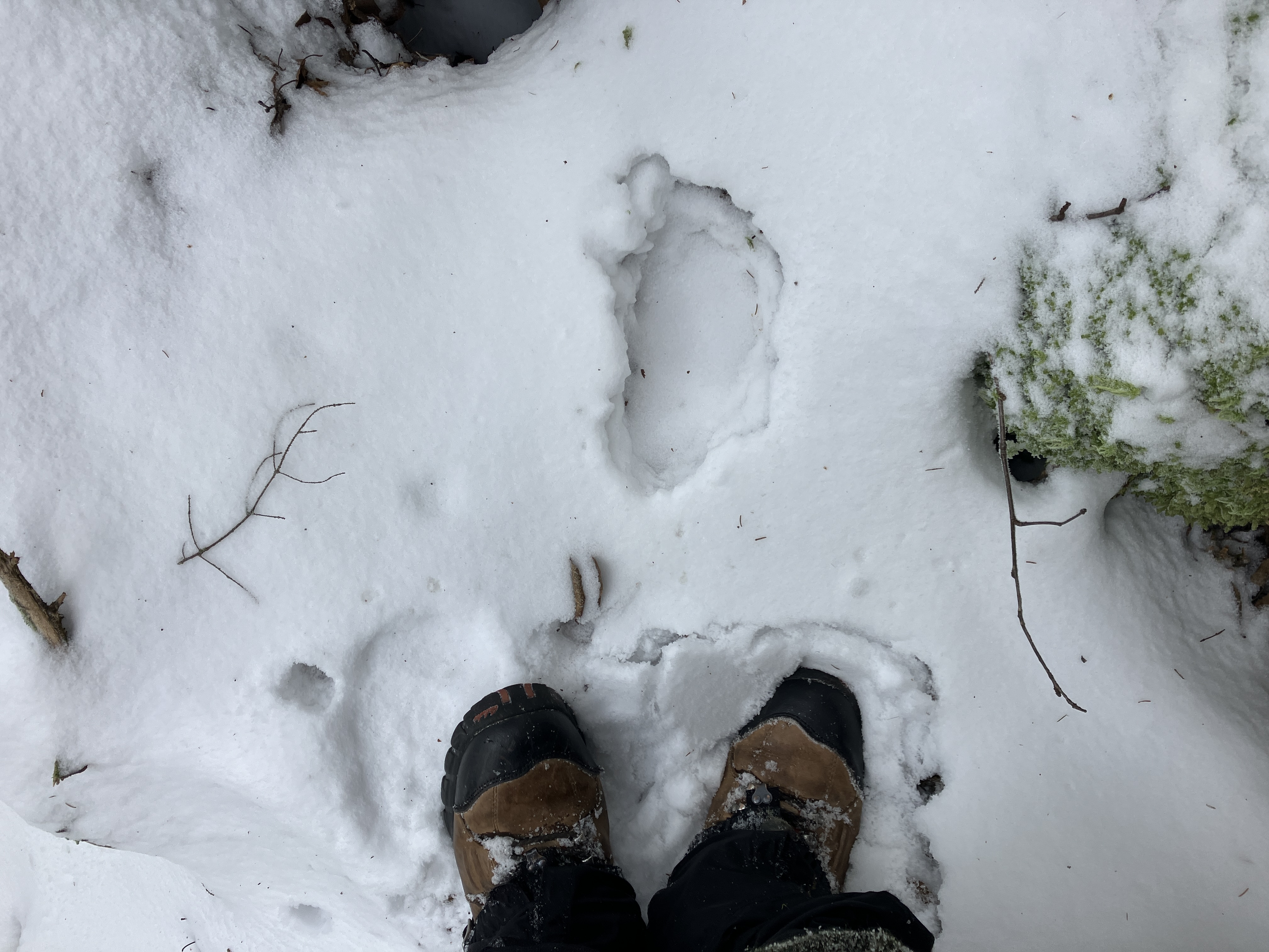
A benefit of the ~2" snow cover was an abundance of animal tracks, such as these partly melted bear tracks leading down to a crossing of Cold Brook.


Cold Brook, looking rather chilly.


The hardwoods go ever on. On this western slope of Tripyramid, between Avalanche Brook and Slide Brook, is a hardwood forest of more than 400 acres, extending up to an elevation of 2900 ft.


More bear tracks, perhaps from the same wandering bruin.


Possibly  red fox?


A mouse or other tiny denizen of the forest floor.


Squirrel?


By noontime the snow in the woods was getting wet and slippery, and I was glad to get back onto the somewhat compacted trail at 2800 ft.


After a steep climb up the lower wooded track of the first South Slide, with some slippery spots (spikes needed for descent), I emerged on the lower open swath.


I made a short, thick bushwhack across to the westernmost open strip of the first South Slide, which I don't recall ever visiting before.


Nice view of Lost Pass from the top of the strip.


Back on the main swath of the first South Slide. I was surprised at how much snow lingered in this sun-exposed opening. The open expanse of this slide must have been huge after it fell in October 1869. For years, until the second South Slide and the North Slide fell in 1885, this was known as "the Great Slide" of Tripyramid.


I found a rock seat and lingered for an hour here in the low November sun, admiring the view of Sandwich Dome and various peaks in western New Hampshire. There was haze in the air - the distant Vermont peaks were only faintly visible.


Mount Tecumseh and its long south ridge, culminating in Dickey and Welch Mountains.


Zoom on Tecumseh, with Mount Moosilauke peeking out on the right.


One of three hardy white pines I've seen on the first South Slide.


Hardwood glade beside the trail, not far below the slide.


Back at the gateway to the Wilderness, where melting had exposed some more ground.


Tuesday, November 14, 2023

A New Slide on the Cannon Balls: 11/13/23

Last Friday, avid hiker, skier and bushwhacker Declan Kiley came by the store and showed me a picture he had taken from Polly's Pancake Parlor in Sugar Hill, where he works. The photo shows a new (this summer, apparently) slide on the north side of the Cannon Balls. Declan noticed it because it was highlighted by the snow. The whitened swath is adjacent to an older long, narrow slide just to the east that descends north from the col between the Northeast and Middle Cannon Balls. Both Declan and I had been to the older slide just last March - he to ski it, and me to snowshoe on it. The next day Carol had geocaching business in Sugar Hill and took a photo that clearly shows the new slide. I had thought there might be new slides somewhere from the past summer's drenching rains, but until now I had heard of none. Many thanks, Declan!


The following Monday was my first chance to head into the Coppermine Brook valley and check out the new slide.  It was a chilly but calm day with sun through early afternoon, a good day for some exploration.


The Coppermine Trail was surprisingly snow-free for the first 1.3 miles.


I always pause to admire this ledgy area on Coppermine Brook. The iron pins on the right were presumably associated with a former logging road bridge over the brook.


Another scenic spot along Coppermine Brook.


Near its upper end the trail meanders through a beautiful hardwood forest.


At 2.3 miles, the trail crosses the brook on a sturdy bridge featuring icy footing this day.


On the far side of the bridge I turned onto the old Coppermine Ski Trail, originally built by the Civilian Conservation Corps in the 1930s and sporadically kept clear today by backcountry skiers.


After an initial steep climb, the trail heads east up the valley, high above the brook.


A set of deer tracks followed the old trail, as well as a set of recent boot tracks. Had a hunter been following those deer tracks, or had Declan come out here to see the slide up close?


When the boot tracks veered off the old ski trail, I figured it was Declan, or some other slide skiing enthusiast, heading up to the new slide. (It turns out it was not Declan, but he plans to go out there soon.) I headed off on my own route towards the slide, hoping to find some open birch glades I had snowshoed through in March. Partway up, I crossed this tributary brook.


The open glades did not materialize.


Instead, I found myself wallowing through seemingly endless tangles of hobblebush.


A glade I had joyfully snowshoed through in March....


...was a different experience minus a three-foot snowpack.


At least there was a nice view of Cannon Mountain through the trees.


I came across the boot tracks again shortly before reaching a scene of devastation at the base of the new slide.


Here was a wide swath where the new slide merged with the icy bottom of the old slide.


This photo of the old slide was taken in 2008 from a ledge (now overgrown) across the valley. The new slide angles up to the right from the bottom at perhaps a 20-degree angle.


Yikes!


Torn and tangled.


Looking up and across to where the old slide joins on the far side.


View from the bottom. This is the cold, shaded side of the Cannon Balls ridge.


Zoom on the upper end, where a wild-looking cliff has been exposed.


I carefully worked my way up through the woods behind the west edge of the slide. The woods weren't too thick, but the terrain was gnarly with rocks and holes, and at least one boulder cave.


Side view, partway up.


Probably a slope of 33 to 35 degrees.


Looking up.


A good-sized bear had been roaming around up here beside the slide.


The bear was weaving its own route through the rough terrain.


I won't be going out to the edge for a look there.


Farther up, at ca. 2900 ft., I picked a way out to the edge and a little shelf with a good view of Mittersill Peak (L) and Cannon Mountain (R). If you look closely you can see the track of an old slide angling down to the left under Mittersill. This slide was prominent on a 1964 aerial photo but is now mostly revegetated.


Welcome to the jumble.


Descending beside the slide, carefully.


Back down through hardwood heaven on the Coppermine Trail.