Friday, December 20, 2024

2024: The Year in Landslides

A retrospective on landslide exploring in 2024, with one slide photo for each month. For a thorough history and documentation of White Mountain slides, see our Google doc, Landslides of the White Mountains (always a work in progress) here.

January: Making tracks on the western of the two Northwest Slides on Scar Ridge. These slides are very old, dating back at least to the 1870s when they were noted by early geologists and AMC explorers.


February: View out to Peak Above the Nubble and beyond from the North Slide of North Twin Mountain, which fell in October 1995 along the track of an old largely revegetated slide. As I was snowshoeing partway up the slide I heard voices below, and before long brothers and avid backcountry skiers Connor and Colby O'Brien climbed past me en route to the top of the slide for a long run down.


March: My seventh (!) visit to the big Northeast Slide on West Sleeper, which fell during Tropical Storm Irene in 2011. Located deep in the Sabbaday Brook valley, it is one of the more impressive swaths in the Whites.


April: A repeat visit to the short, slabby slide on the steep south face of Smarts Mountain, which may have fallen during the big November 1927 rainstorm. The spur known as Lambert Ridge, traversed by the Appalachian Trail, is seen on the right.


May: Relaxing on the remnants of an old slide on the headwall of Avalanche Ravine, en route to North Tripyramid, with the Osceolas and Mount Moosilauke seen in the distance. This was one of several slides in Avalanche Ravine that fell in the same storm that triggered Tripyramid's huge North Slide on August 13, 1885.


June: Looking out from the big North Slide in Mount Moosilauke's aptly-named Slide Ravine, which likely came down in the late 1950s. Part of the largest slide on the ravine's southeast wall can be seen on the left. Smarts Mountain and Mount Cube are visible in the distance.


July: The view from "Little Arrow Slide," a smaller slide located just to the west of Mount Hancock's well-known Arrow Slide. The Osceolas and Scar Ridge sprawl in the distance.


August: An unusual view of King Ravine on Mount Adams from a steep ledge located on the track of a huge slide that fell on the west wall of the ravine during Hurricane Carol in 1954. The track of this slide - which was for a short time used by RMC crew members as an alternate route to Crag Camp - is now almost completely revegetated except for a few jutting outcrops.


September: A six-mile approach, including a long bushwhack up a valley, was required to reach the massive East Slides of Giant Mountain in the Adirondacks. From north to south these slides are a half-mile across. The ascent to the top of the slides requires technical climbing over a very steep ledge barrier.


October: Another long bushwhack, up the Hellgate Brook valley, brought me for a third visit to the big Guitar Slide on the south face of West Bond, with its unsurpassed view of Bondcliff.  The widest of the six slides on this slope, it probably fell either during the November 1927 storm or the September 1938 hurricane.


November: This largely hidden two-pronged slide came crashing down in a remote valley between Mount Liberty and Little Haystack Mountain during the October 1995 rainstorm. It offers one of the best views I've seen of North and South Kinsman and their adjacent ridges.


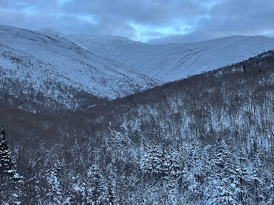
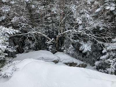
December: This snowy corridor is the track of a western tributary slide to the large Southwest Slide on Mount Liberty, which, along with the great West Slides on Mount Flume, was unleashed by a storm in June 1883. The Southwest Slide was notable for sweeping the suspended boulder out of its perch between the walls of The Flume.

Happy Holidays and Best Wishes for the New Year!


Saturday, December 14, 2024

Lafayette Brook Ledges: 12/13/24


After the big rainstorm and subsequent freeze, I figured many trails would present an unpleasant mix of conditions. I was hoping that the snow off-trail had consolidated and would provide some good snowshoe bushwhacking. I headed back to the Gallen Memorial parking area at the north end of Franconia Notch to undertake a favorite whack to two view ledges on the ridge north of Lafayette Brook. Mt. Lafayette was emerging from the clouds as I crossed the old highway bridge by the Gallen Memorial.


There were a few patches down low that had melted down to leaf cover, but overall a good portion of the previous snow cover remained, now in a crunchy, mealy form.


A little sun in the hardwoods added a touch of warmth on this cold morning.


Making tracks through the hobblebush, which proliferates on the lower part of the ridge.


Tall and gnarled.


Snowpack still a foot plus.


Heading up to the crest of the ridge through conifers and birch.


Making switchbacks on steeper pitches.


Rough, ledgy terrain on the crest of the ridge.


It's wild up here.


After squeezing through some dense scrub I emerged on the first ledge viewpoint on my itinerary, looking across at Eagle Pass.


Nice view of Cannon.


An interesting angle on Mt. Lafayette and its massive western shoulder.


Zoomed. From this perspective the bulbous North Peak looks higher than the summit.


These ledges drop off sharply into the forest.


After a scrap with prickly conifers I broke out into a pretty little col on the ridge.


Better going in birches behind the ridgecrest.


Here I came upon a freshly made moose track, which was heading in the direction I was going.


The moose appreciated the open going in the birch glade as much as I did.


I call this stretch birch glade nirvana.


Sweet snowshoeing.


At the edge of the birch glade there's an abrupt transition to darker woods.


In here the snow was crustier, with a couple of mini-scrambles.


Following the moose tracks through wonderfully open woods.


It wasn't steaming, but it looked pretty fresh.


Good snow cover as I circled around the back side of a steep wooded knob to access the upper view ledge.


Cresting over the top of the knob.


This perch has a commanding view over the lower half of the Lafayette Brook valley and far off westward to the Green Mountains in Vermont. The small white stripes on the right are the bridge by the Gallen Memorial and part of I-93.


A nice profile of Cannon and its two spur peaks.


The sharp cut of Eagle Pass.


The tip of North Peak and the summit crest of Lafayette just peer over the next hump up the ridge. With a temperature in the low teens, the wind was brutally cold out on the ledge, but I was able to take an extended break back in the trees while still enjoying most of the view.


Heading back down through the open woods. The snowshoe descent was a little slower than usual due to the mealy and somewhat unstable snowpack, which led to a fair amount of snowshoe wobble.


Always a joy to descend through the birches!


Tuesday, December 10, 2024

Old Bridle Path Snowshoe: 12/9/24

I had a few hours free for a snowshoe jaunt before snow moved in late afternoon. I headed up to Franconia Notch with the idea of probing farther up the ridge north of Lafayette Brook, if I could follow the tracks I had made three days earlier. But the most recent snowfall had completely covered my tracks, and the trail breaking was that much harder with an additional 5-6" of soft snow. After taking in the view of Mt. Lafayette from the bridge by the Gallen Memorial, I drove back south to climb to the longtime favorite outlooks on Old Bridle Path.


There was a beautiful packed snowshoe track on Old Bridle Path, soft enough for enjoyable 'shoeing.


A pretty hefty snowpack for early December. Too bad about the heavy rain headed our way.


Signage at a planned relocation around a badly eroded section.


Snow-draped passageway.


A somewhat tricky little ice bulge on the scrambly section below the outlook ledges.


Tunneling.


First peek at the ridge.


A more open vista from the first ledge outlook.


Looking up Agony Ridge and the north branch of Walker Ravine. On Halloween I bushwhacked up the valley to the little open slide patch seen right of center, and basked in 70-degree sun.


Old slide tracks spilling down off the ridge.


Walker Ravine North, overlooked by Mt. Lafayette.


Walker Ravine South, between "Truman Peak" and Mt. Lincoln. It's fun to look at various slides I've visited in these ravines during recent winters.


Dry Brook Ravine, between Mt. Lincoln and Little Haystack.


Snow-packed scrub heading up to the upper outlook in this series.


View back to the south under leaden skies.


The Kinsmans, a few minutes before they were smothered by incoming clouds.


The ridge going under, time to head down.


Parting shot.